Thursday 15th March 2018 – Sunday 18th March 2018

Hi all,

Beast from the East 2. The sequel. Snow until Easter. I’ve heard it all this week. There’s some truth in those headlines and with it a disappointing outlook as Spring seems to be on hold.

Thursday: Mostly cloudy and windy across the region but with it some mild temperatures. Rain will be coming up from the south but will turn patchy at times and eventually fizzle out with hopefully some late-afternoon brightness. Max 9°C

Friday: Another cloudy and windy day with some showery rain at times, mainly in eastern areas. Feeling a little cooler too, especially later with a chance that some of the rain could turn to sleet or snow on the hills as colder air arrives. Max 7°C

Weekend: Bitterly cold, windy.

Saturday: A strong easterly wind feeding in much colder conditions. Gusts to 40mph likely. A similar pattern to when we had the Beast From the East but not as cold/snowy and it will not last as long. During the day some light snow showers could develop, but at this stage no significant snow is expected. Temperatures struggling above freezing with a severe wind-chill for the time of year making it feel like -5°CMax 2°C

Sunday: Remaining very cold with those biting winds from the east. Any snow flurries or showers tending to fade as the supply from the east gets cut off as high pressure builds. Max 3°C

Outlook: After a very cold 2-day spell over the weekend, it will become less cold but the search for anything Spring-like continues, with temperatures expected to remain below average throughout the next 5 days.

Follow @ChadWeather on Twitter for the latest weather forecasts.

Forecast Issued on Wednesday the 14th of March 2018 at 1:45pm.

Thanks,
Jon

Thursday 8th March 2018 – Sunday 11th March 2018

Hi all,

Well what a week that was. The ‘Beast From the East‘ certainly delivered. The official snow depth here was 12cm on the 1st of March and we had many days of snowfall, severe wind-chill, travel disruption and then very strong winds gusting locally to 55mph. Of course, weather-wise, we’re now into Spring and we say goodbye to Winter 2017-18, which turned out the ‘snowiest’ I’ve ever recorded since my records began in late-2012.

Extremes Recorded during the Beast From the East – all new records

Lowest Temp= -6.1°C (28th Feb)
Lowest Wind-chill= -12.0°C (1st Mar)
Lowest Apparent Temp= -12.1°C (1st Mar)
Lowest ‘Feels Like’ Temp = -13.3°C (1st Mar)
Lowest Daytime Max Temp= -2.4°C (28th Feb)

But the Lowest Dew Point record of -12.7°C, from the 25th of March 2017, remained intact.

Here’s how previous winters have compared.

Winter Stats

Comparing the last 6 winters


So can we expect something warmer and Spring-like soon?

Thursday: A cloudy damp start with some rain, sleet and hill-snow. Some settling snow is possible above 250M (2+cm), and especially so over the Pennines (5+cm), so check the roads if you’re travelling trans-Pennine routes. At the time of this blog there is a warning in place. This should all clear mid-morning with bright spells and showers following. Some of the showers heavy, perhaps wintry with hail and thunder. Max 6°C

Friday: We will start with a slight frost and some ice in places. Not a bad day in store with sunny spells and dry. Feeling pleasant in the sunshine. Cloudier later with rain overnight. Max 7°C

Weekend: Wet then drier; Sunday the better day

Saturday: A keen southeasterly wind. Rain, some heavy,  lasting most of the day. Just a few drier slots at times. Early on, there is a slight chance of some snow on the Pennines for a few hours but this is a low risk as it will get progressively milder. Max 9°C

Sunday: Yesterday’s rain clears quickly to leave a drier day with variable cloud allowing for some sunny spells here and there. Mild and it will be the first time we have reached double-figure temperatures since the end of January. Max 11°C

Outlook: Slighly cooler after Sunday with some showers at times which could be wintry. Milder later in the week with southwesterly winds dominating.

February 2018 Stats

Max 9.7°C (19th)
Min -6.1°C (28th)
Av. 2.5°C (colder than average)
Wettest 11.8mm
Windiest 44mph
Rain 60.8mm (drier than average)
Rainy Days 16
Dry Days 12
Air Frosts 14 (more than average)
Snow Falling Days 10
Snow Lying Days 6

Follow @ChadWeather on Twitter for the very latest weather updates.

Thanks,
Jon

Forecast Issued: Wednesday the 7th of March 2018 at 5pm.

Thursday 1st March 2018 – Sunday 4th March 2018

Hi all,

Thursday sees a change of season in the Weather World. Spring has sprung! Well not quite! Although our winter ends today [Wednesday], the weather has gone back in time, as the much-promised Beast From the East arrived bringing snow, tumbling temperatures and a severe wind-chill this week. So when will it all end? In fact, when will we get above freezing again?

Thursday: Like yesterday, one of the coldest days for years. An extreme wind-chill making it feel like -12°C. A mostly cloudy day, there could be some brightness from time-to-time, but equally some more snow showers. These should ease later. Winds strong, gusting to 40mph. Max -2°C

Friday: Bright spells and a few snow flurries. Then later in the day, the forecast is not set in stone, but there is a risk of some snow coming up from the south-west, accompanied by a strong south-easterly wind making it feel like -10°C and gusting to 45mph. As I say, the track of the low pressure, which has been named Storm Emma by the Portuguese Weather Centre, is uncertain, so the snow event might not happen and this is confirmed by the GIF below. The snow tries its best to arrive across the region towards the evening, but fizzles out. The forecast could change so watch out for tweets. Max 0°C

Snow on Friday

Heavy snow will cause disruption in southwestern parts of the UK but will it make it here

Weekend: Still very cold but less so into Sunday. Some snow.

Saturday: Still Baltic but not as windy as Friday. Cloudy with some snow flurries then perhaps a spell of snow for a few hours. Max 1°C

Sunday: Less cold air will push across the region which will recover the temperatures a little and after days of sub-zero values, we will sneak above 0°C. Again, mostly cloudy with a cold wind and the potential is there for some snow showers. Still very cold. Max 3°C

Outlook: Remaining colder-than-average with some wintry showers, so the risk of some snow remains. No sign of our first taste of spring. Don’t thank me, thank Sudden Stratospheric Warming. 

A huge thank you for all your photos, road updates and interactions this week.

Follow @ChadWeather on Twitter for the latest.

Thanks,
Jon

Forecast Issued at 17:10 on Wednesday the 28th of February 2018
Image: wxcharts.eu

Bitter Cold and Snow Update

Hi all,

Just a ‘quick’ blog to keep you updated on the up-and-coming coldest weather for years.

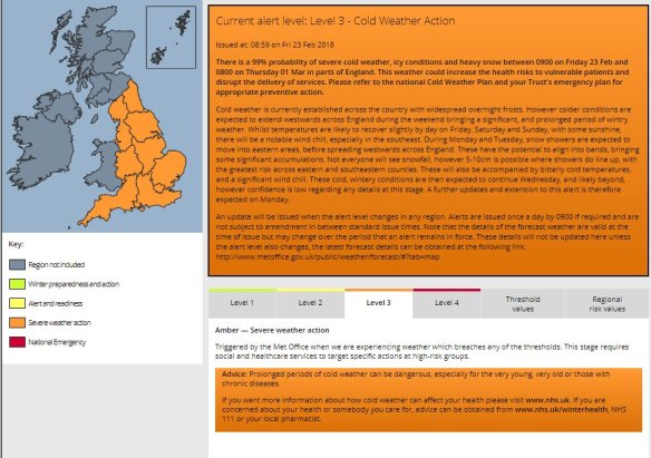
The Met Office have issued a Level 3 Cold Weather Alert for this week. This is one short of a National Emergency. This highlights the severity of this week’s cold.

Cold Weather Alert

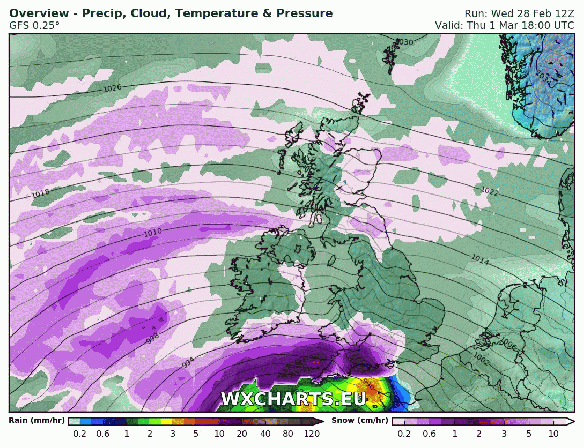
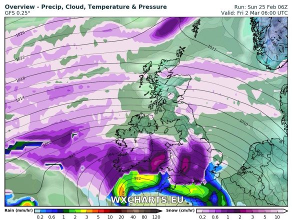
For the past few days we have been dragging in cold air from the east (as mentioned in last week’s blog) but during this week, even colder air (aka The Beast From The East) will filter westwards all the way from Siberia, with some extreme wind-chill values for the UK. As this air comes across the relatively warmer North Sea, it will develop snow showers which will be heavy and possibly thundery. The strength of the wind will move them well inland.

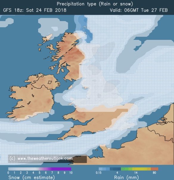
The bitter weather is set to last all week with some uncertainty from Friday. During Thursday night into Friday it looks like a low pressure will come up from the south. This is going to bring widespread snow and blizzards to southern parts of England and Wales. It’s too early to say how far north this will come but there is a chance we will see some snowfall from it. After that milder air will try to arrive from the south-west but it might not succeed, or, if it does, it’ll take several days for temperatures to recover. One thing that seems certain this week is that there will be some significant and disruptive snowfall for parts of the UK.

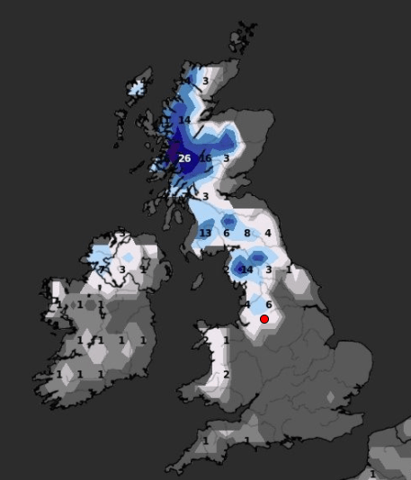
Snow: I’m expecting all of us to see snow at some point over the week. There won’t be any rain falling, anything that falls will be snow, even to sea-level as it will be so cold. The snow showers could easily bring 3-5cm for most of us, with the chance of 10-15cm over the Pennines and surrounding hills as they take a direct hit from the showers firing in on a, at times, gale-force gusting easterly wind. Warnings are in place and more could follow.

Snow Tuesday morning

Snow showers will start to feed in from the NE in the early hours of Tuesday morning

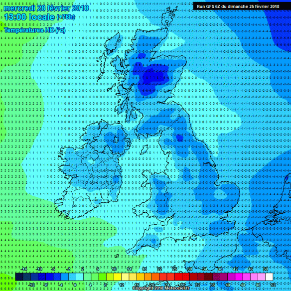
Temperatures: Daytime highs will struggle above freezing and are expected to remain below freezing on Wednesday and Thursday at least. There will be hard penetrating frosts all week with lows down to -7°C, and -10°C in rural spots, especially over snow-cover.

Weds Maximums

Wednesday’s maximums – add on the wind and it will be Baltic

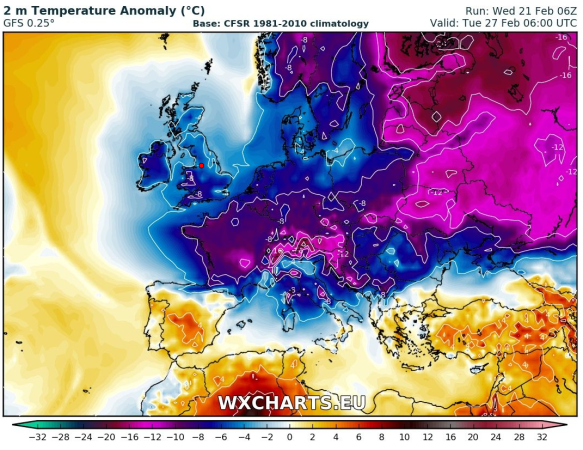
Wind-chill: All week the wind-chill will be sub-zero and midweek it is likely to start to feel like -12°C or lower.


Severe Windchill Thursday AM

Severe wind-chill this week – values as low as -12°C to -14°C in places by Thursday

Sunday: Sunny spells but feeling cold in the wind. Remaining dry. Max 4°C

Monday: The much colder air has arrived and with it more cloud than recent days. Sunny spells, a biting wind and perhaps some snow flurries later in the day. Max 2°C

Tuesday: During the early hours and into the morning there is a risk of some prolonged snow arriving from the NE, especially so in eastern parts. After this clears it’s a day of bright spells and scattered snow showers. Feeling very cold with a -7°C wind-chill. Max 1°C

Wednesday: A bitterly cold day with frequent snow showers from the east filtering well inland. Heaviest of the showers in eastern areas. Some of the showers could be thundery and there will be drifting of any lying snow as winds gust 30mph. Max 0°C

Thursday: Mostly cloudy, some light snow showers but there should be less than yesterday. Severe wind-chill (-12°C) and the coldest day for years. Max -1°C

Snow Event Friday

A significant snow event looks possible next Friday which will cause disruption

Friday: Much uncertainty but likely to be cloudy, freezing cold with light snow arriving from the south. It will also be very windy with 40mph gusts. Again wind-chill values down to -10°C or lower. Further updates during the week. Max 0°C

Just to note: Snowfall is difficult to predict when it arrives in the form of showers. Some areas will see a lot more snow than others as showers produce localised amounts.

Follow @ChadWeather on Twitter to keep up-to-date with the severe weather this week.

Thanks
Jon

Images: www.theweatheroutlook.comhttp://www.meteociel.fr/http://wxcharts.eu, Met Office.

Thursday 22nd February 2018 – Sunday 25th February 2018

Hi all,

There’s been a lot of talk for a few days now, about colder weather on the way. I mentioned last week that winter wasn’t finished with us just yet and looking at the computer models parts of the UK could be in for some significant snow and bitterly cold temperatures as we enter next week. Deep cold will be dragged across Europe on an easterly wind, sometimes called The Beast From The East, into the UK from Siberia and the recent SSW (Sudden Stratospheric Warming) is to blame. This is still not 100% guaranteed though, after this morning’s updates from the computer models, but it is still favoured.

I’ve seen some models give us days of subzero temperatures, even during the daytime. I just feel we need another day or so to firm up details on how cold it will get and how much, if any, snow will fall. It does seem likely that from Friday our ‘feels like’ temperature will remain sub-zero for several days. Keep up-to-date by following my tweets on Twitter.

Thursday: Dry with variable amounts of cloud. Some patchy frost to start then a day of mostly cloudy skies and some bright spells coming and going. Max 6°C

Friday: Frosty early and more sunshine on offer and with it plenty of dry weather. You will start to feel the edge on that breeze as the colder air from Europe arrives. Max 5°C

Weekend: Dry and slowly even colder. A biting wind-chill.

Saturday: A frost to start then dry with sunny spells. A keen wind-chill as the easterly wind picks up, gusting to 25mph. Max 5°C

Sunday: Windy, with bright spells but more cloud compared to Saturday so feeling colder. The bitter wind-chill digging in, making it feel more like -7°C. Max 3°C

7 degrees below average

Into next week and we could be seeing temperatures 6-8°C below average (av. Max = 7°C)

Outlook: Even colder air will arrive from the east and with it the increasing chance of some snow flurries. Daytime temperatures will struggle to get above freezing and frosts will continue at night. As we approach midweek there is some uncertainty as to whether we keep the very cold easterlies or switch to slightly less cold northerlies. The risk of snow is likely to increase too. Some computer models predict the colder-than-average conditions to continue into the second week of March, but some have us back in milder southwesterlies by March the 6th. Just to note: One set-up has some heavy snow for us around the 3rd of March with night-time temperatures as low as -10°C. A long way off but just a hint of what might be possible with the forthcoming very cold airmass.

Follow @ChadWeather on Twitter for the latest forecasts.

advice

Thanks,
Jon

Forecast Issued: Wednesday the 21st of February 2018 at 12:30pm
Images: http://wxcharts.eu

Thursday 15th February 2018 – Sunday 18th February 2018

Hi,

Only a couple of weeks left of winter and recently we’ve felt its presence with some more snowfall and cold temperatures, but, change is on the way. However, don’t be thinking of putting away those thick coats just yet, as winter might not be done with, after the recent Sudden Stratospheric Warming event.

Thursday: A reasonable day with some bright spells and milder than recently. There will be the odd wintry shower and a fresh breeze. Max 7°C

Friday: Dry with sunny spells and feeling pleasant. Max 8°C

Weekend: Mostly dry with light winds as pressure builds.

Saturday and Sunday: Mostly cloudy with some bright spells. Feeling quite mild. Just the risk of some drizzle in any thicker cloud, especially on hilltops. Max 9-10°C

HP

High pressure in charge next week so a lot of overdue drier weather on the way

Outlook: High pressure in charge and at first the position of the high will lead to mild and settled conditions. As the week progresses the high could well slip north and introduce cold, then very cold, easterly winds. Initially the focus will be on it feeling bitter but with a lot of dry and overcast weather.

Follow @ChadWeather on Twitter for your latest weather forecasts.

Thanks,
Jon

Forecast Issued at 13:45 on Wednesday 14th February 2018
Image: http://wxcharts.eu

Thursday 1st February 2018 – Sunday 4th February 2018

Hi all,

January is coming to a close and with just a month left of winter, who’s looking forward to Spring and those lighter mornings and evenings? I know I am, but I’m still hoping for some more snow before we get there.

Thursday: Cold with bright or sunny spells and windy. Just the chance of an isolated wintry shower during the morning mainly in western areas. Max 5°C

Friday: A cold and frosty start then a reasonable day with sunny spells and a chilly wind. Cloudier later in the day. Max 5°C

Weekend: Chance of snow

Rain arriving from the west on Saturday could turn to snow

Saturday: A very cold day. Cloudy with rain pushing in from the west. Snow is possible on higher ground (mostly >200M) but not exclusively. So, with a chance of snow to lower-levels, watch out for updates on Twitter. Later into the evening we return to a few wintry showers. Max 3°C

Sunday: A return to the brighter weather with a cold wind and sunny spells. The odd wintry shower possible in eastern areas. Max 5°C

Outlook: Remaining cold throughout with bright spells, slight frosts and some wintry showers. Tuesday/Wednesday could see a band of rain which could turn to snow in places. One to watch.

Follow @ChadWeather on Twitter for the latest forecasts.

Thanks,
Jon

Forecast Issued: Wednesday the 31st of January 2018 at 7:15pm
Image: www.theweatheroutlook.com

Thursday 25th January 2018 – Sunday 28th January 2018

Hi all,

It’s back to the normal British winter. No snow or proper cold in the next 7 days.

Thursday: A few bright spells during the morning but some showers, perhaps heavy and thundery, will arrive into the afternoon and last into the evening. Max 8°C

Friday: A reasonable day. Light winds, some sunny spells and mostly places escaping with a dry day. A touch cooler. Max 7°C

Weekend: Milder with some rain.

Saturday: A dry start but cloud thickening with some outbreaks of rain and drizzle, especially on higher ground, arriving from the southwest. Turning milder. Max 10°C

Mild

Perhaps a 13°C in some spots on Sunday

Sunday: Cloudy and dull with some patchy light rain and drizzle. Some areas sheltered from the southwesterly wind will remain dry. Much milder with a fresh breeze. Max 12°C

Outlook: A trend towards slightly less mild conditions as we enter February. It looks like we will settle down a touch too, with high pressure close by. No sign of anything particularly cold or snowy but a chance of a few slight frosts.

Follow @ChadWeather on Twitter for the latest forecasts.

Thanks,
Jon

Forecast Issued at 13:15 on Wednesday the 24th of January 2018
Image: http://wxcharts.eu/

Thursday 18th January 2018 – Sunday 21st January 2018

Hi all,

We are halfway through winter and we were reminded this week with snow returning to some parts as well as plenty of hail and some thundersnow. After last week’s dank slow-weather days we are back up and running with plenty to talk about. There is some more snow on the way.

Lightning 160118

Lightning Strikes: Tuesday saw thunder and lightning, giving some of us thundersnow

Thursday: The early hours and early morning will be very windy with 50-55mph gusts across the region as a low pressure moves through. The thinking was that this system would be named but it is now less intense and therefore hasn’t been christened. It will briefly become milder but during the morning winds will die down somewhat and it will become colder again. After all that we will see a day of sunshine and frequent thundery wintry showers which will fall as snow above 200M. Max 5°C

Snow showers on Friday

Wintry showers, including some snow, will be blown in again on Friday

Friday: A colder day and windy with more wintry showers feeding in. Again, these could be thundery with hail and snow. Snow showers expected almost anywhere but especially on higher ground where it is likely to settle. Max 3°C

Snow Depth cm by the end of Friday

Predicted snow depth (cm) by the end of Friday

Weekend: Saturday’s the day!

Saturday: A frosty start with snow-cover in places from yesterday’s showers. However a decent day ahead. Dry with sunny spells and cold. A perfect winter’s day. Max 4°C

Sunday: A cold start and perhaps briefly dry. Rain (timings still uncertain at this stage) will then move in from the west preceeded by snow in places, especially on the hills and Pennines, but all areas seeing it turn to rain as it becomes slowly milder later. A thaw of any remaining lying snow. Max 7°C

Outlook: Temperatures average for the time of year but with our weather favouring coming in from the Atlantic, we can expect some spells of rain at times. Chilly nights with some patchy frost.

Follow @ChadWeather on Twitter for frequent weather updates.

Thanks,
Jon

Forecast issued: 10:15am on Wednesday the 17th of January 2018
Images: https://www.lightningmaps.org and http://wxcharts.eu 

Thursday 28th December 2017 – Sunday 31st December 2017

Hi all,

I hope you all had a great Christmas and have managed to return to feeling less stuffed. So it wasn’t a White Christmas here but we did see some snow on the higher routes on Boxing Day morning. As you’ve probably seen, we missed out on another snow event last night as a band of heavy rain mixed with the cold air further south and brought chaos to some of the motorway and road networks. When will it be our turn?

Thursday: A cold and frosty start for most but there is a chance that we could see a few sleet or snow showers earlier in the morning which might give a dusting in places. A nice day will follow with plenty of winter sunshine. A slight breeze making it feel bitter. Max 3°C

Friday: Change on the way. Cloud and light rain, perhaps preceded by snow for a few hours, will move in quickly from the west. The snow may settle briefly especially on the hills and Pennines. After a drier slot further rain will arrive later and with it milder air. Max 6°C

Weekend: Milder and windy.

Saturday: Windy with some showers and drier spells in between. Mostly cloudy and notably milder. Max 10°C

New Year’s Eve: Staying windy with gusts to 40mph and after a spell of rain showers will follow. Remaining mild but feeling colder with the wind. Be prepared for some rain into the evening and around midnight but don’t let it dampen your celebrations. Max 9°C

Outlook: Staying lively as the Jet Stream gathers pace, with rain and windy spells at times. Mostly mild but colder spells in between low pressure systems.

Finally, thanks for all your tweets and support this year. I wish you all the very best for 2018, have a good one!

Thanks,

Jon

Follow on Twitter at @ChadWeather.

Hourly weather data at @OldhamWxStats.

Weather data every minute at https://www.wunderground.com/personal-weather-station/dashboard?ID=IOLDHAMC2.

Forecast Issued at 12:25pm on Wednesday the 27th of December 2017.