Hi all,
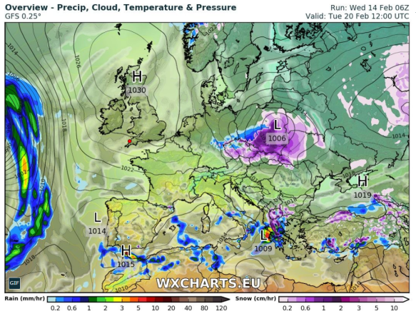
There’s been a lot of talk for a few days now, about colder weather on the way. I mentioned last week that winter wasn’t finished with us just yet and looking at the computer models parts of the UK could be in for some significant snow and bitterly cold temperatures as we enter next week. Deep cold will be dragged across Europe on an easterly wind, sometimes called The Beast From The East, into the UK from Siberia and the recent SSW (Sudden Stratospheric Warming) is to blame. This is still not 100% guaranteed though, after this morning’s updates from the computer models, but it is still favoured.
I’ve seen some models give us days of subzero temperatures, even during the daytime. I just feel we need another day or so to firm up details on how cold it will get and how much, if any, snow will fall. It does seem likely that from Friday our ‘feels like’ temperature will remain sub-zero for several days. Keep up-to-date by following my tweets on Twitter.
Thursday: Dry with variable amounts of cloud. Some patchy frost to start then a day of mostly cloudy skies and some bright spells coming and going. Max 6°C
Friday: Frosty early and more sunshine on offer and with it plenty of dry weather. You will start to feel the edge on that breeze as the colder air from Europe arrives. Max 5°C
Weekend: Dry and slowly even colder. A biting wind-chill.
Saturday: A frost to start then dry with sunny spells. A keen wind-chill as the easterly wind picks up, gusting to 25mph. Max 5°C
Sunday: Windy, with bright spells but more cloud compared to Saturday so feeling colder. The bitter wind-chill digging in, making it feel more like -7°C. Max 3°C
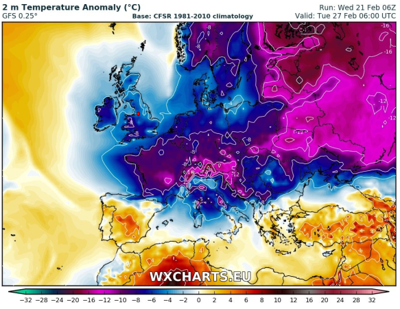
Into next week and we could be seeing temperatures 6-8°C below average (av. Max = 7°C)
Outlook: Even colder air will arrive from the east and with it the increasing chance of some snow flurries. Daytime temperatures will struggle to get above freezing and frosts will continue at night. As we approach midweek there is some uncertainty as to whether we keep the very cold easterlies or switch to slightly less cold northerlies. The risk of snow is likely to increase too. Some computer models predict the colder-than-average conditions to continue into the second week of March, but some have us back in milder southwesterlies by March the 6th. Just to note: One set-up has some heavy snow for us around the 3rd of March with night-time temperatures as low as -10°C. A long way off but just a hint of what might be possible with the forthcoming very cold airmass.
Follow @ChadWeather on Twitter for the latest forecasts.

Thanks,
Jon
Forecast Issued: Wednesday the 21st of February 2018 at 12:30pm
Images: http://wxcharts.eu