Remaining unsettled even towards month-end as a possible warmer and drier spell looks unlikely – Thursday 20th September 2023 – Sunday 23rd September 2023

Hi all,

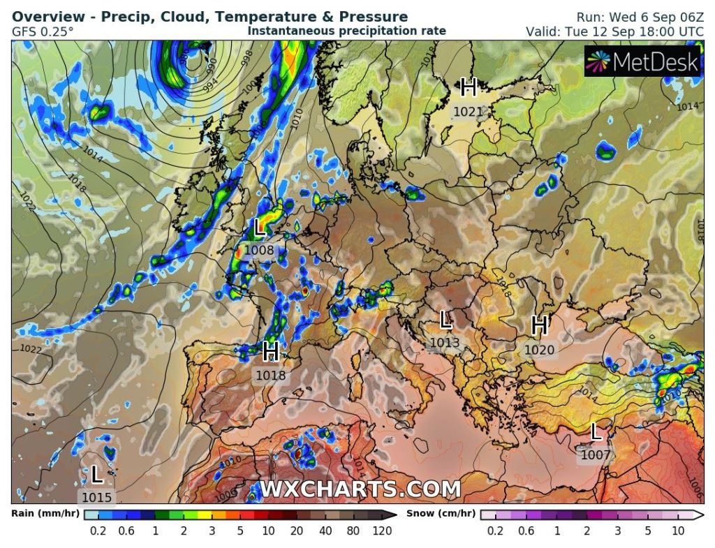
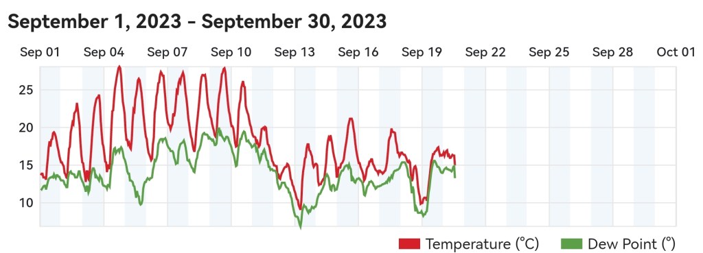
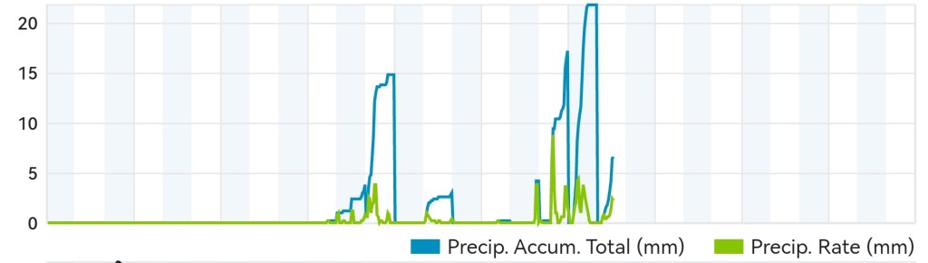
After a lovely dry, hot at times, and sunny start to September it’s well and truly paying us back with some proper autumnal weather. We’ve had almost two inches of rain in the last 2-3 days and there’s more rain to come, but this time in the form of showers during the rest of the working week.

Temperatures have taken a dip after the summery start to September
A dry start to September has been replaced by full-on autumn

The media have reported another “Indian Summer” on the way. Well a) we didn’t have an “Indian Summer” earlier this month so we can’t have another and b) there was a possible summer-like spell on the way for the end of the month, but this is now in doubt and c) we can’t have an “Indian Summer” until we get some widespread frosts first.

Some chilly nights over the next couple of days as the milder air is pushed away to the SE

Thursday: A better day than the last two with bright spells and the odd shower on the cards. It’ll be fresher too with a cool start and another chilly night to come. Winds much lighter than earlier in the week but still breezy. Max 15°C Min 7°C

Friday: Winds will swing more westerly then eventually north-westerly making it feel cool. Frequent showers are expected, some thundery, and it will be windy, especially during any downpours. Max 14°C Min 7°C

Weekend: Brief ridge of high pressure on Saturday.

Saturday: A drier day in prospect but with mostly cloudy skies after early brightness. A little milder, notably overnight, and winds swinging back to south-westerly later. Max 15°C Min 12°C

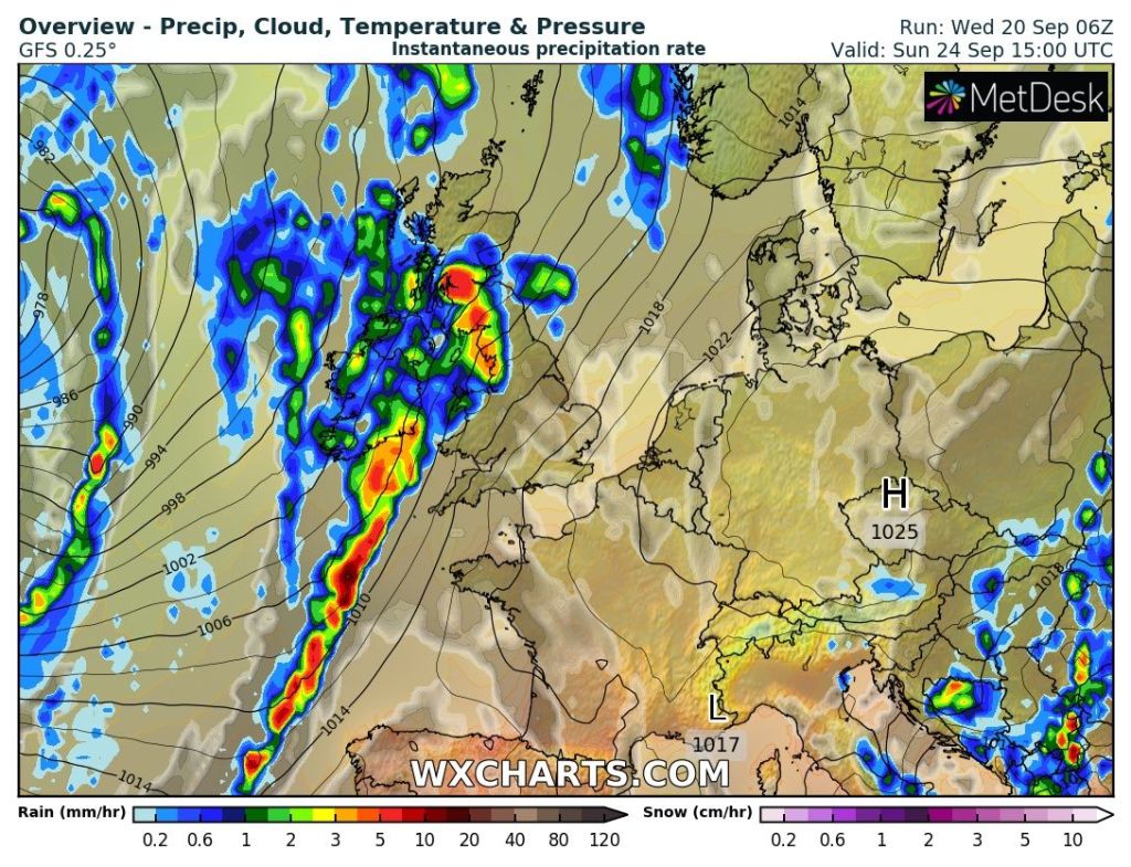
Sunday: Cloudy but dry to start then wind and rain will arrive leading to a miserable afternoon. Milder and windy, with 35mph gusts. Max 18°C Min 14°C

After a drier Saturday, rain is expected again Sunday afternoon

Outlook: Temperatures around average, late-teens, and a showery pattern is expected for most of the week. There were signs of something warmer, drier and settled for the end of the month, as I mentioned on an X post, but the chances of this happening are now fading fast.

It looks like September will end unsettled, despite the earlier indication of a warmer and sunnier spell for month-end

Follow @ChadWeather on X for the latest forecasts and warnings.

Thanks,
Jon

Forecast Issued: Wednesday the 20th of September 2023 at 3:52pm.
Images: http://www.wetterzentrale.de & http://www.wxcharts.com

From a heatwave to more Autumnal weather – Thursday 14th September 2023 – Sunday 17th September 2023

Hi all,

Thankfully it’s a lot fresher (for now!) than it was during the latter stages of that heatwave. A record dew point was recorded for September and although I enjoyed the dry and sunny weather, going to sleep with temperatures close to 30°C is not pleasant. Tuesday night was cold with a widespread frost in Scotland and a ground-frost in Northern England showing how quickly conditions can change in September.

A frosty start for some on Wednesday morning

I’m still to get around to doing all my weather stats from late-2012 to 2023. I need more time. This data will come one day, I promise.

Thursday: A mostly cloudy start with rain during the morning and then again later at night. Some bright spells in between feeling cool with a slight breeze which should ease later. Max 17°C Min 12°C

Friday: A weather-front will stall early on bringing dank conditions and patchy rain. But the current thinking is this should ease away from the region, moving north, during the morning leading to drier day with some warm bright spells. Milder and turning a little humid later. Max 19°C Min 13°C

Weekend: A little uncertainty on rainfall amounts.

Saturday: Looking humid with a risk of hefty and perhaps thundery showers breaking out as low pressure, to the south-west of the UK, controls our weather. A noticeable keen north-easterly wind. Max 19°C Min 14°C

Humid air set to return later this week

Sunday: Similar with a muggy feel with rain or showers at times, some heavy. The exact positioning of these showers will be easier to forecast nearer the time. Quite warm despite the conditions and again a breezy day. Max 20°C Min 13°C

Outlook: Fresher with more of an Atlantic influence bringing bright spells in between spells of showers or prolonged rain. Temperatures around average.

An unsettled outlook from Monday

Follow @ChadWeather on X for the latest forecasts and warnings.

Thanks,

Jon

Images: http://www.wxcharts.com & data provided by Highland Weather on X.

Forecast Issued on Wednesday the 13th of September 2023 at 6:16pm.

Heatwave to continue with muggy nights, but the breakdown is in sight – Thursday 7th September 2023 – Sunday 10th September 2023

Hi all,

It’s not unusual to have nice weather either side of summer, normally in May and September. So, having high pressure in place leading to wall-to-wall sunshine is no surprise, but the temperatures that we are experiencing, especially in the south-east of the UK are unusually high for the time of year. This is down to the decent weather appearing early in September, so not further into Autumn, and also France and Spain are still hot, into the 30s. The weather set-up is called an Omega block.

More here: https://news.sky.com/story/uk-heatwave-what-is-an-omega-block-and-how-is-it-causing-our-extreme-weather-12956027

Some will call it an Indian Summer, and I used to, but that’s premature. This is reserved for later in Autumn when a warm and dry spell follows the first frosts or the first killing-frost. Scotland has already had frosts this September, but in England and Wales we are nowhere near that stage in our weather.

Interesting stats from Aidan McGivern. Maximum temperatures per month and the year they occurred. September is the longest standing one.

The humidity has increased today so, if you haven’t moaned already, it’ll be too hot for some.

How long does it last? Here’s your 4-day forecast and a peek into the rest of next week.

As always thanks for reading and interacting on X.

Wednesday Night: More in the way of cloud with just the chance of an isolated thunderstorm later in the night. Very warm and humid. Min 19°C

Thursday: Not as much sunshine as recently to start, with mid-level cloud, possibly sparking an isolated thundery shower, however these are more likely to stay out in the Irish Sea. Into the afternoon further hot sunny spells will break through. Max 27°C Min 17°C

Friday: Light winds but with a misty/low-cloud start. It won’t take long for hot sunny spells to burn through once more. Max 29°C Min 17°C

Weekend: Low pressure to the west increasing the instability but the heat will still be around.

Saturday: Looks like the last day of some decent lengthy sunny spells. After a misty start it will be another hot day as further hot air wafts up from the south. Cloud will bubble up but the chance of a shower seems slim. Humid and hot, possibly 30°C in some spots. Max 29°C Min 18°C

Intially it looked like Wednesday or Thursday would be the peak of the heat but now it could well be Saturday with 30°C not to be ruled out.

Sunday: One more day of the heatwave to come with hot sunny spells once more.  Cloud could well bubble-up enough to deliver some evening thunderstorms or a sharp shower. Max 28°C Min 15°C

Outlook: Low pressure replaces high pressure. Bright spells, showers at times, some thundery, especially on Monday as the heatwave ends. Cooler too with temperatures eventually back to maximums of only 19°C by midweek. Not a washout though with some sunny periods as well as showers. What will be noticeable though, will be the cooler nights, with lows close to single-figures.

More unsettled next week but not a washout.

Follow @ChadWeather on X for the latest forecasts and warnings.

Thanks,
Jon

Forecast Issued: Wednesday the 6th of September 2023 at 5:42pm
Images: http://www.theweatheroutlook.com & http://www.wxcharts.com & X