Reasonable then a risk of more unsettled weather next week but with not much rain in the forecast – Thursday 25th July 2024 – Sunday 28th July 2024

Hi all,

The weather is sort of uneventful at the moment with little in the way of mobile conditions and with brief ridges of high pressure bringing warm, settled conditions but without any wall-to-wall sunshine. Basically average. It’s not too wet at the moment either and not much rain is expected, so time to start watering those lawns and gardens.

We might not be hot on the thermometer but that’s still a strong sun up there and it’s very warm when it’s out and the UV levels are still high.

Hard to believe August is almost here. Yep, the last month of “summer”.

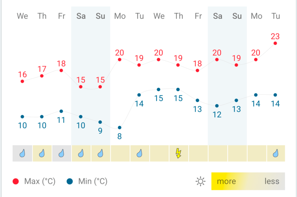
Thursday: It will be a muggy day with moist southwesterly winds which will be quite breezy during the morning. Cloud will be thick enough to produce some drizzle early on, but cloud should tend to thin later into the afternoon and we should see the odd bright spell which could set off a localised shower. Max 21°C Min 13°C

Quite muggy on Thursday with SW winds

Friday: A better day in prospect with plenty of sunny spells, but it will be windy. Most of any showers should stay confined to the northwest of the UK, but it’s still possible that we could catch an isolated one during the afternoon. Less humid than Thursday with fresher air in place. Max 20°C Min 12°C

Lower dew points on Friday means fresher air will be in place.

Weekend: Sunday looks best.

Saturday: Sunny spells and showers. Some of them could be heavy and the wind will veer northwesterly at times and be a little gusty, especially during any downpours. If you’re lucky enough to avoid showers then it should be quite a reasonable day with showers easing towards evening and therefore we should see more in the way of sunshine. Max 20°C Min 11°C

Showery on Saturday

Sunday: We’re looking at a dry day with sunny spells and lighter winds compared to Saturday. Feeling pleasant in the sunshine and don’t forget you still burn easily at this time of year. Warmer. Max 23°C Min 12°C

Outlook: It looks like next week we will see a bit more of an influence from the Jet Stream. So we could see a couple of areas of low pressure bringing spells of rain and wind. In between the Azure’s high pressure will ridge up across the southwest of the country, so will give us some brighter days and drier days in between.

Not that much rain expected in the next 10 days. I think this graphic is a little optimistic but we will see.

Follow @ChadWeather on X for the latest forecasts and warnings.

Thanks as always for stopping by to read.

Jon

Forecast Issued: Wednesday the 24th of July 2024 at 5pm.

Images: www wxcharts.com & theweatheroutlook.com

Briefly hot then a thundery breakdown to cooler air & an unsettled outlook – Thursday 18th July 2024 – Sunday 21st July 2024

Hi all,

Finally something much warmer, briefly hot, but it’s not here for long before temperatures return back to normal for the weekend. But, it will be welcome after July has been disappointingly cool. Up to Tuesday, July was, on average, cooler than June and May! But warmer temperatures this week, especially with muggy nights, will lift the average somewhat.

Just to note: There isn’t a heatwave coming to the region despite what the media report and that includes a ‘mini-heatwave’ as they don’t exist.

The threshold for a heatwave, 25°C, has to be met for 3 consecutive days and this will not be met over the next few days.

Thursday: Mostly cloudy with the odd bright spell for the morning with the odd scattered shower out west. Any sunshine will tend to become hazy as cloud spills in from the west after lunchtime and some showers could run up the western side of the region later. Humid night. Max 24°C Min 16°C

Friday: A very warm-to-hot day, depending on how far northwest the heat from the southeast can reach. Sunny spells and it should remain dry with just the outside chance of a shower. Warm night. Max 25-27°C Min 15°C

Weekend: We lose Friday’s heat and temperatures will return to around normal after a cold-front moves through. Turning unsettled during Saturday.

Muggy Saturday evening with high dew points

Saturday: Sunny spells for the morning but then cloud will increase and a band of thundery showers will move through later in the day. This will introduce much cooler air. Breezy later. Max 23°C Min 12°C

The heat breaks during Saturday where we could see some hefty downpours and thunderstorms later in the day

Sunday: A better day with sunny spells but only after morning showers have eased away. Much fresher now and windy at times too. Max 20°C Min 11°C

Much fresher air arrives for Sunday

Outlook: I can’t see any sign of another warm/hot spell with conditions/temperatures expected to be disappointing for the time of year with occasional bright spells and showers. So generally unsettled but with the odd drier spell in between bands of showers.

I guess September will be a decent month then? Because summer isn’t behaving.

Follow @ChadWeather on X for the latest forecasts and warnings.

Thanks,

Jon

Forecast Issued: Wednesday the 17th of July 2024 at 4:36pm.

Images: http://www.theweatheroutlook.com

Remaining cooler-than-average with showers at times – Thursday 11th July 2024 – Sunday 14th July 2024

Hi all,

The miserable summer continues and although it’s been muggy at times this week, especially on Tuesday, there’s been quite a bit of rainfall and Tuesday saw most places see up to an inch of rain followed by evening thunderstorms in the west. 

High pressure is going to try its best to squeeze in from the west as we head towards the weekend but it won’t establish itself fully over the UK; so it’s not going to be exclusively dry even though the weather will settle down a little bit. Looking ahead, no sign of any summer heat returning just yet, but perhaps a hint of something a few degrees warmer in about a week’s time.

Thursday: Unfortunately, a weak weather-front will establish itself across the region. We can expect a cloudy day with patchy rain here and there and some drizzle during the morning. During the afternoon the patchy rain and drizzle should turn into scattered showers with the odd heavy one. Max 17°C Min 11°C

Friday: It should be a better morning on Friday with a few bright spells but cloud will bubble up as the day wears on and there will be the odd scattered shower but some places will stay dry. We’ll have a cooler airflow now so it won’t feel as muggy as it has done earlier in the week. Max 17°C Min 11°C

Showers this weekend

Weekend: High pressure close by but we can still expect showers.

Saturday: High pressure to the northwest of the UK. Low pressure over in Europe. In between a little bit of instability meaning a bright start but clouds will bring the odd scattered shower into the afternoon, which could be heavy. Max 17°C Min 10°C

Sunday: Little change really, bright spells for the morning, clouds bubbling up later producing some scattered showers, which could be heavy again and thundery. Not much change in the maximum temperature. Max 18°C Min 11°C

Cooler-than-average this weekend

Outlook: It looks like it will remain changeable throughout the week. Bright spells and showers developing and temperatures likely to stay just below average. Later in the week there are hints that maybe a little bit of warmer air will waft up from the south, but with this being 7 to 9 days away there is still a lot of uncertainty on this occurring. The wait for our summer heat in July continues.

Follow @ChadWeather on X for the latest forecasts and warnings.

Thanks,

Jon

Forecast Issued Wednesday the 10th of July 2024 at 9:15pm

Images: http://www.wxcharts.com

Remaining unseasonably cool & a little unsettled but when will the heat return? – Thursday 4th July 2024 – Sunday 7th July 2024

Hi all,

June was, on average, a cooler month than May! This is the first time this has ever happened in my weather records, going back to August 2012 and it is the first time it has happened across the UK.

The average (mean) CET (Central England Temperature) was lower in June than May for the first time since 1833!

Also to note: June was a much drier-than-average month too with only 47% of the average rainfall recorded.

Comparing June 2024 to May 2024. Images: @RoostWeather on X.

Thursday: Low pressure to our north-east. Limited bright/sunny spells and a few showers especially so in northern parts. It will also be a windy day with gusts to 25-30mph making it feel cool at times but a little milder than Wednesday. Max 17°C Min 10°C

Bright spells and showers on Thursday

Friday: A small feature will be drifting in, but at this stage it looks likely to drift across the south of the UK. If this stays true to the forecast then it’s a day of bright spells then turning cloudier from the south later and it should be mostly dry until rain overnight. Max 17°C Min 10°C

Hopefully we avoid this little system bringing rain to southern England on Friday

Weekend: Unsettled.

Saturday: Below-average temperatures, windy and showery. Some of the showers will be heavy with the risk of hail and thunder and some could merge during the morning to give some longer spells of rain. The showers should ease somewhat into the evening. Cool for the time of year. Max 16°C Min 9°C

Sunday: Little change so showers are expected, still heavy and possibly thundery, though winds will ease later. Max 16°C Min 10°C

Outlook: Temperatures should begin to lift a little but only slowly. The Jet Stream will remain in control so a mixture of sunny spells and beefy showers after perhaps a lull on Monday. No sign of high pressure building in and sticking around to bring a settled, drier and warmer spell. The wait in July goes on.

Hopefully warmer (slightly) times ahead but don’t hold your breath

June 2024 Stats

Max 26.1°C (26th)
Min 5.4°C (5th)
Av. 13.7°C
Av. Max 17.1°C
Av. Min 10.2°C
Max Dew Pt 17.8°C
Av. Dew Pt 9.1°C
Wettest 10.4mm (9th)
Av. Barometer 1014.8 hPa
Max Gust 25mph
Av. Wind Direction W
Rain 36mm (47% of average)
Rain Registered Days 17
Dry Days 13

Follow @ChadWeather on X for the latest forecasts and warnings.

Thanks,
Jon

Forecast Issued: Wednesday the 3rd of July 2024 at 5:36pm
Images: @RoostWeather on X & http://www.wxcharts.com & Weather&Radar