Unsettled but signs of a good end to summer – Thursday 22nd August 2024 – Bank Holiday Monday 26th August 2024

Hi all,

It’s been a disappointing week with some days letting us know that summer will soon be gone and autumn is coming. We have further wind and rain to come as areas of low pressure bringing unsettled conditions to our region over the coming days.

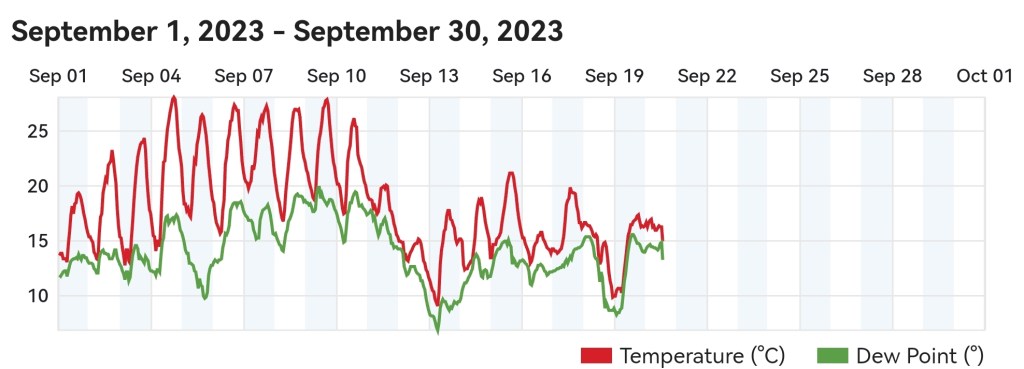
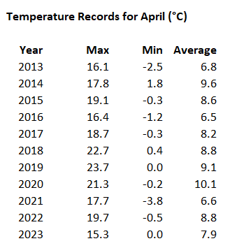
August 2024 so far, has been much drier-than-average conditions, with only 23mm of rain falling here in Chadderton. The average for the whole month is 92mm. I have records since 2013 and August 2024 currently has an average temperature (day and night) of 16.5°C. This is the second warmest I’ve recorded with only August 2022 (17.6°C) coming in warmer.

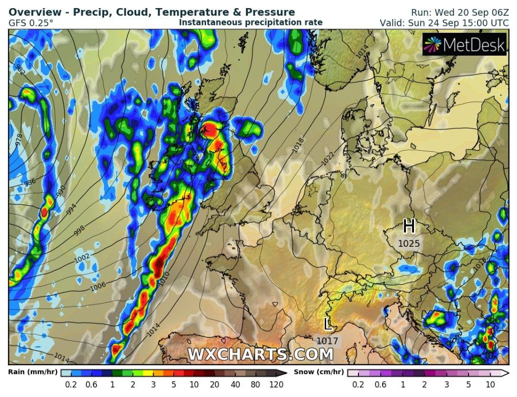
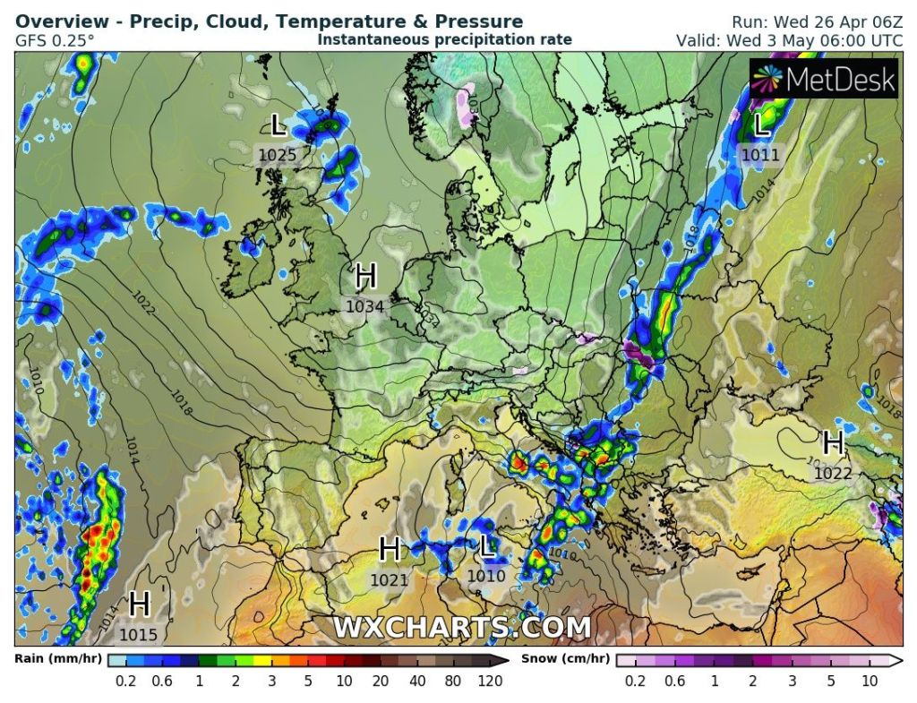
One area of low pressure with have the remnants of ex-Hurricane Ernesto mixed in. Apart from some unseasonal windy weather, there’s nothing much to worry about, with the worst of the winds out in the Irish Sea.

Very windy in the Irish Sea and along the western coast for a time during the early hours of Thursday as the remnants of ex-Hurricane Ernesto is mixed in with this low pressure.

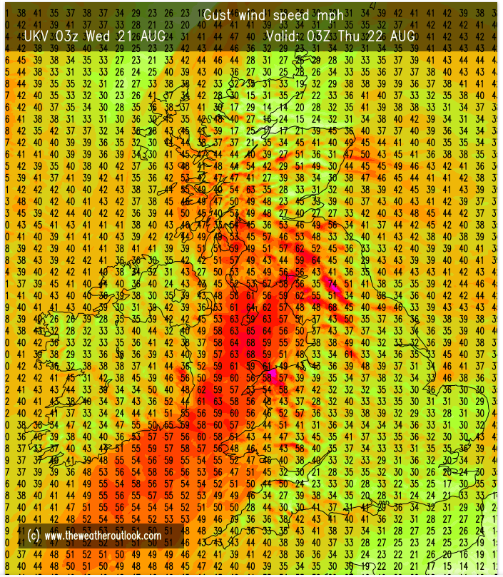
Thursday: A wet and windy morning is expected with 40mph gusts as a band of rain moves through. A few hours of heavy rain likely before the afternoon improves with bright spells and a drier and sunnier end to the day. Winds easing into the evening. Max 18°C Min 11°C

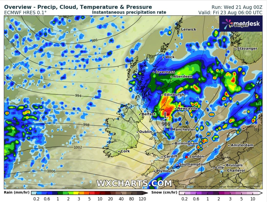
Friday: Another area of low pressure looks to form quickly and race across the area. So Friday will start wet with rain during the early hours, turning showery into the morning. Showers will tend to ease later in the day and more in the way of sunshine is expected. This low pressure is expected to bring more windy weather. Gusts could reach 40-50mph during the morning before the winds transfer away to the northeast. Given the time of year, don’t be surprised to see a weather warning issued as the low deepens across northern England. Max 18°C Min 10°C

A lively start to Friday as this low brings some gusty winds for a time before quickly heading into the North Sea.

Weekend: Windy with showers but some sunshine too.

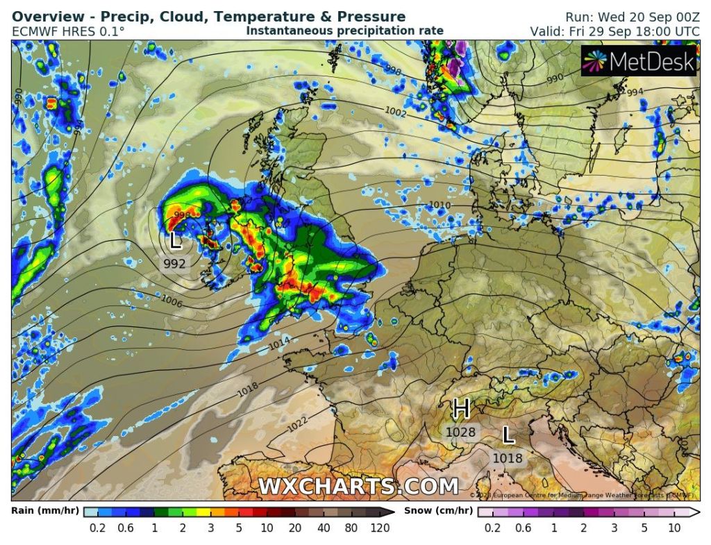
Saturday: With the two recent areas of low pressure moving on, we still remain in a mobile set-up thanks to the Jet Stream. Since we are in between systems, then a day of showers and sunny spells looks to be the order of the day. Windy and fresh air in place. Max 17°C Min 11°C

Sunday: Albeit remaining breezy, on the whole it looks a better day with the odd shower and sunny spells. With the weather in a bit of an unsettled pattern, forecasts can change quickly, so look out for updates on X. Milder air filtering in overnight. Max 18°C Min 13°C

Bank Holiday Monday: A little bit warmer but mostly cloudy with some brightness. Rain won’t be too far away, to our northwest, with the potential for it to arrive later in the day. Breezy. Max 21°C Min 14°C

Outlook: At the time of writing it looks like the weather will become warmer and sunnier for the final few days of August, and perhaps even to start autumn (standard behaviour as the kids return to school) as high pressure slips in from the southwest at times. Of course, it’s a long way off, so take it with a pinch of salt but fingers crossed we can see a late summer-burst with temperatures close to the mid-20s.

Follow @ChadWeather on X for the latest forecasts and warnings.

Thanks for reading as always, much appreciated.
Jon

Forecast Issued: Wednesday the 21st of August 2024 at 12:31pm
Images: http://www.theweatheroutlook.com & http://www.wxcharts.com

Remaining unseasonably cool & a little unsettled but when will the heat return? – Thursday 4th July 2024 – Sunday 7th July 2024

Hi all,

June was, on average, a cooler month than May! This is the first time this has ever happened in my weather records, going back to August 2012 and it is the first time it has happened across the UK.

The average (mean) CET (Central England Temperature) was lower in June than May for the first time since 1833!

Also to note: June was a much drier-than-average month too with only 47% of the average rainfall recorded.

Comparing June 2024 to May 2024. Images: @RoostWeather on X.

Thursday: Low pressure to our north-east. Limited bright/sunny spells and a few showers especially so in northern parts. It will also be a windy day with gusts to 25-30mph making it feel cool at times but a little milder than Wednesday. Max 17°C Min 10°C

Bright spells and showers on Thursday

Friday: A small feature will be drifting in, but at this stage it looks likely to drift across the south of the UK. If this stays true to the forecast then it’s a day of bright spells then turning cloudier from the south later and it should be mostly dry until rain overnight. Max 17°C Min 10°C

Hopefully we avoid this little system bringing rain to southern England on Friday

Weekend: Unsettled.

Saturday: Below-average temperatures, windy and showery. Some of the showers will be heavy with the risk of hail and thunder and some could merge during the morning to give some longer spells of rain. The showers should ease somewhat into the evening. Cool for the time of year. Max 16°C Min 9°C

Sunday: Little change so showers are expected, still heavy and possibly thundery, though winds will ease later. Max 16°C Min 10°C

Outlook: Temperatures should begin to lift a little but only slowly. The Jet Stream will remain in control so a mixture of sunny spells and beefy showers after perhaps a lull on Monday. No sign of high pressure building in and sticking around to bring a settled, drier and warmer spell. The wait in July goes on.

Hopefully warmer (slightly) times ahead but don’t hold your breath

June 2024 Stats

Max 26.1°C (26th)
Min 5.4°C (5th)
Av. 13.7°C
Av. Max 17.1°C
Av. Min 10.2°C
Max Dew Pt 17.8°C
Av. Dew Pt 9.1°C
Wettest 10.4mm (9th)
Av. Barometer 1014.8 hPa
Max Gust 25mph
Av. Wind Direction W
Rain 36mm (47% of average)
Rain Registered Days 17
Dry Days 13

Follow @ChadWeather on X for the latest forecasts and warnings.

Thanks,
Jon

Forecast Issued: Wednesday the 3rd of July 2024 at 5:36pm
Images: @RoostWeather on X & http://www.wxcharts.com & Weather&Radar

Missing the worst of Storm Babet – Thursday 19th October 2023 – Sunday 22nd October 2023

Hi all,

I’ve been out and about today so a quick blog tonight. Storm Babet is battering the UK, but we will miss the worst of the conditions. I am expecting it to very windy, which will be more noticeable coming from the east and southeast. 40-50mph gusts can’t be ruled out during Wednesday and Friday and yes it will be wet at times but the warning for the rain only just brushes the region.

Eastern areas will see the most rainfall from Thursday to Saturday (inc.)

Thursday: Cloudy with some rain to start. Brighter spells for the afternoon but also some showers at times. Mild for the time of year and with lighter winds some of the showers could be slow-moving and thundery. Max 17°C Min 13°C

Friday: A dry start then rain is expected to move in from the east. A little uncertainty on the positioning of the low to our east so details might change. Otherwise a wet afternoon and also a strong and gusty north-easterly wind. Cooler. Max 14°C Min 9°C

Rain will spread in from the east on Friday but still some uncertainty on how far west it gets

Weekend: Turning cooler.

Saturday: Low pressure in charge and some showery rain at times. Not as windy but feeling colder. Max 11°C Min 8°C

Sunday: Hopefully not too bad of a day and the calm after the storm for the UK. Mostly cloudy some brightness and lighter winds. Still cool with some isolated showers later. Max 12°C Min 7°C

Outlook: Temperatures around average and generally unsettled with showers at times.

Follow @ChadWeather on X for the latest forecasts and warnings.

Thanks,
Jon

Forecast Issued: Wednesday the 18th October 2023 at 9pm
Images: http://www.wxcharts.com and The Met Office

Remaining unsettled even towards month-end as a possible warmer and drier spell looks unlikely – Thursday 20th September 2023 – Sunday 23rd September 2023

Hi all,

After a lovely dry, hot at times, and sunny start to September it’s well and truly paying us back with some proper autumnal weather. We’ve had almost two inches of rain in the last 2-3 days and there’s more rain to come, but this time in the form of showers during the rest of the working week.

Temperatures have taken a dip after the summery start to September
A dry start to September has been replaced by full-on autumn

The media have reported another “Indian Summer” on the way. Well a) we didn’t have an “Indian Summer” earlier this month so we can’t have another and b) there was a possible summer-like spell on the way for the end of the month, but this is now in doubt and c) we can’t have an “Indian Summer” until we get some widespread frosts first.

Some chilly nights over the next couple of days as the milder air is pushed away to the SE

Thursday: A better day than the last two with bright spells and the odd shower on the cards. It’ll be fresher too with a cool start and another chilly night to come. Winds much lighter than earlier in the week but still breezy. Max 15°C Min 7°C

Friday: Winds will swing more westerly then eventually north-westerly making it feel cool. Frequent showers are expected, some thundery, and it will be windy, especially during any downpours. Max 14°C Min 7°C

Weekend: Brief ridge of high pressure on Saturday.

Saturday: A drier day in prospect but with mostly cloudy skies after early brightness. A little milder, notably overnight, and winds swinging back to south-westerly later. Max 15°C Min 12°C

Sunday: Cloudy but dry to start then wind and rain will arrive leading to a miserable afternoon. Milder and windy, with 35mph gusts. Max 18°C Min 14°C

After a drier Saturday, rain is expected again Sunday afternoon

Outlook: Temperatures around average, late-teens, and a showery pattern is expected for most of the week. There were signs of something warmer, drier and settled for the end of the month, as I mentioned on an X post, but the chances of this happening are now fading fast.

It looks like September will end unsettled, despite the earlier indication of a warmer and sunnier spell for month-end

Follow @ChadWeather on X for the latest forecasts and warnings.

Thanks,
Jon

Forecast Issued: Wednesday the 20th of September 2023 at 3:52pm.
Images: http://www.wetterzentrale.de & http://www.wxcharts.com

Briefly hotter & humid with a risk of thunderstorms – Thursday 6th July 2023 – Sunday 9th July 2023

Hi all,

June 2023, as you will have heard, broke records, see the image below from the Met Office.

It really was a decent summer month but how does it compare locally to recent Junes.

Well here are the statistics from Chadderton HQ.

The monthly average for June 2023 stands out as a clear winner but we have had drier Junes but 22 dry days in 2023 is still impressive with some of the rain falling from thundery downpours.

Thursday: A bright start but cloud will tend to spread in from the south-west on an increasing breeze. This will begin to drag up warmer air. A few showers can’t be ruled out later into the afternoon with some localised brightness. Warmer. Max 21°C Min 14°C

Friday: Looking likely to be the best day of the 4-day forecast. Hot sunny spells developing after a cloudy start. We keep the rain-bearing clouds to the west. Sunshine hazy at times. It will be humid too with a warm night ahead. Windy throughout. Max 26°C Min 18°C

We avoid the rain on Friday but Ireland gets a soaking.

Weekend: Nearby low brings instability then fresher air.

Saturday: Another very warm and humid day with sunny spells to start. It won’t take long for showers to brew and these will grow and become more widespread into the afternoon with thunderstorms likely as they push north-east. It will also be another windy day. There could well be a warning issued for localised flooding. Cooler overnight. Max 24°C Min 14°C

Thundery showers moving north-east during Saturday.

Sunday: A fresher day with bright spells and the odd shower. Not as windy and temperatures down several degrees. Max 21°C Min 12°C

Outlook: The disappointing month continues with a showery theme and temperatures back into the teens. I did mention, in a previous blog, that the heat could return mid-month. Well, there’s no sign of that happening anytime soon with the heat remaining over Spain for now.

June 2023 Stats

Max 29.9°C (12th)
Min 8.4°C (4th)
Av. 17.3°C
Wettest 14.2mm (18th)
Av. Humidity 71%
Av. Barometer 1019.1 hPa
Max Gust 15mph
Av. Wind Direction E
Rain 48.6mm (67% of average)
Rain Registered Days 8
Dry Days 22

Follow @ChadWeather on Twitter for the latest forecasts and warnings.

Thanks,
Jon

Forecast Issued: Wednesday the 5th of July 2023 at 5:51pm.
Images: http://www.wxcharts.com & the Met Office.

Beefy showers with a thundery mix and quite humid at times – Thursday 4th May 2023 – Bank Holiday Monday 8th May 2023

Hi all,

That’s two months of Spring done and it’s not exactly been a warm one. Disappointing to be fair and you would think by now we would have had, or due imminently, a spell of maximum temperatures into the 20s, but nope, nothing on the horizon. April did come out with below-average rainfall though.

The next 10 days look set to be dominated by mostly west or south-westerly winds, so moist air, a bit humid at times and spells of rain or showers. With the sun having some strength at this time of the year, unstable air means convection and showers brew which could be thundery with hail.

Thursday: Windy, gusting 30mph, with some pleasant sunny spells at times. UV levels medium. Cloud increasing into the evening with showery rain arriving from the south-west signalling a change to more unsettled weather. Max 16°C

Looking at quite a bit of rain, over the next 7 days. Total amounts will vary due to localised downpours.

Friday: An unsettled day with hefty showers breaking out just about anywhere. These will be thundery with a risk of hail and also slow-moving with less of a breeze. Low risk of localised flooding in any downpours. Max 15°C

Downpours on Friday. Chance of thunder & lightning with hail.

Weekend: Sunday likely to be the driest or should I say least wet.

Saturday: A dry start but mostly cloudy. Showers arriving late-morning, if not then into the afternoon, again possibly thundery and hanging around for most of the day. A little humid. Max 16°C

Sunday: Showers are expected for the morning but hopefully it will tend to become drier into the afternoon but stay mostly cloudy. Pleasant in any bright spells. Max 16°C

Bank Holiday Monday: A generally cloudy and dry morning with some brightness. Showery rain expected again as the day progresses. Max 17°C

Outlook: Little change. If anything it might stay on the cool side with temperatures struggling to the mid-teens. Still no sign of our first 20°C. It really has been a poor Spring on the thermometer.

Wet days ahead and disappointing temperatures.

April 2023 Stats

Max 17.3°C (29th)
Min 0.0°C (25th)
Av. 8.2°C
Wettest 9.2mm (10th)
Av. Humidity 77%
Av. Barometer 1017.1 hPa
Max Gust 38mph
Av. Wind Direction SE
Rain 56mm (89% of average)
Rain Registered Days 14
Dry Days 16

Follow @ChadWeather on Twitter for the latest forecasts and warnings.

Thanks,
Jon

Forecast Issued: Wednesday the 3rd of May 2023 at 5:50pm
Images: http://www.wxcharts.com; http://www.weatherandradar.co.uk

Becoming milder but sunshine lacking – Thursday 27th April 2023 – Bank Holiday Monday 1st May 2023

Hi all,

It’s not been the best April when it comes to warmth with temperatures below-average. It’s the 4th coolest April looking back through the last 11 years of my data. We haven’t risen above 15°C yet.

At least the last week or so hasn’t been as wet as earlier in the month. Rainfall amounts are currently coming in at 86% of average.

The second half of April hasn’t been as wet as the first.

Thursday: A fresh start in places with sunny spells. Cloud thickening into the afternoon with rain eventually arriving into the evening, with some heavy bursts. Temperatures up a notch on recent days. Max 13°C

A wet Thursday evening is on the cards.

Friday: Early rain will fizzle away but it will remain cloudy. Hopefully some late-in-the-day sunshine to come. Milder. Max 15°C

Weekend: Feeling a little warmer but lacking in sunshine.

Saturday: A mostly cloudy day as we sit in a slack airflow in between weather systems. This means light winds hence the stubborn cloud. A few bright spells later will help to lift the temperatures but could spark isolated showers. Max 16°C

Sunday: Showers are expected to be more frequent in between mostly cloudy skies. Light winds mean any showers will be slow-moving. Max 15°C

Bank Holiday Monday: Occasional bright spells and showers. Bit more of a breeze. Max 14°C

Outlook: A tricky set up. A weak area of high pressure will be close by but not strong enough to bring dry and sunny conditions every day. More like variable cloud for most of the week, so brightness at a premium and some showers brewing up. Temperatures around average.

High pressure next week but it’s weak.

Follow @ChadWeather on Twitter for the latest forecasts and warnings.

Thanks,
Jon

Forecast Issued: Wednesday the 26th of April 2023 at 5:30pm.
Images: http://www.wxcharts.com

Unsettled at first then much-improved and temperatures rise for a promising week – Thursday 13th April 2023 – Sunday 16th April 2023

Hi all,

As predicted we had a settled Easter and also much more sunshine than I thought. It wasn’t that warm on the thermometer but it was perfect during the day and the sun felt so warm. The sun is now as strong as late-August and suncream is needed if you don’t want to burn and are in the sun between 11am-3pm.

Our weather has now turned poor once again and it’s been a wet and windy week as well as being cooler as the Jet Stream drives weather systems across from the Atlantic.

But, good news, we have another settled spell on the way and with any luck temperatures could get close to 20°C. Only downside might be a nagging south-easterly or even easterly wind. Before this what do the next four days hold…..

Thursday: The low pressure of recent days, Storm Noa, is still affecting our weather. Feeling chilly with a brisk westerly wind and frequent showers. Windy with 30-35mph gusts especially in downpours. Chance of hail, and thunder and lightning. Max 9°C

The set-up on Thursday favours a very showery day.

Friday: Mostly cloudy with a few showers. Not as cold and not as windy. Risk of some evening rain which will clear overnight. Max 11°C

Weekend: Getting milder and drier.

Saturday: Sunny spells to start then cloud building. It is likely to stay dry. Temperatures edging up. Max 13°C

Sunday: A mostly cloudy day with some bright spells later. A southerly wind lifting temperatures, a sign of things to come. Max 16°C

Outlook: High pressure to our north-east introducing a, gusty at times, breeze from the south-east. Sunny spells and a lot of dry weather for most of the week with temperatures lifting to 17-19°C, depending on the wind direction/position of the high pressure. If winds turn easterly then the west will be the warmest place to be. With clear spells at night it will be chilly at times.

I’m hopeful this decent weather will still be around for next weekend. First BBQ of the season?

Above average temperatures favourable next week.

Follow @ChadWeather on Twitter for the latest forecasts and warnings.

Thanks,
Jon

Forecast Issued: Wednesday 12th April 2023 at 8:20pm.
Images: http://www.wxcharts.com

A decent Sunday then more high pressure but will it turn colder? – Thursday 2nd February 2023 – Sunday 5th February 2023

Hi all,

The third and final month of winter is here. It’s a month that can bring mild and moist weather with temperatures into double-digits but also bitterly cold, snowy weather from eastern Europe. We could well see both scenarios in the coming weeks but for now we remain above-average on the thermometer and I’m not mentioning those 4 words yet!

Thursday: A mostly cloudy day with the chance of some hill-drizzle. Breezy with temperatures above average. Max 11°C

Friday: Another mild day with further cloudy skies. Perhaps some brightness developing into the afternoon which will help to lift the temperatures. Breezy again. Max 12°C – perhaps 14°C in some local spots sheltered in the east.

Weekend: Becoming colder but brighter.

Saturday: Any bright start fading as cloud builds from the north-west and a weather-front moves south-east bringing some patchy rain into the evening. Patchy frost later in the night as skies clear. Max 11°C

Sunday: That weather-front is a cold-front so Sunday will be cooler but with it much brighter skies and with high pressure building we should see a good amount of sunshine. Some frost overnight. Max 8°C

Outlook: High pressure that builds over the UK on Sunday will slip away into the continent as the week goes on but still control our weather. It all depends where this high pressure sits, with what weather we see next. If it moves over Scandinavia then we could import some easterly winds meaning that it will turn much colder with the risk of snow flurries. If the high pressure slips further south we will be in a milder south to south-westerly airflow. Literally at the moment the outcome is uncertain but it’s probably favouring the milder weather 60:40. One thing to note is the week looks mostly dry with sunny spells and some overnight frosts. Updates on Twitter.

January 2023 Stats

Max 11.9°C (4th)
Min -2.5°C (17th)
Av. 4.9°C
Wettest 24.8mm (10th)
Av. Humidity 88%
Av. Barometer 1012.9 hPa
Max Gust 35.7mph
Av. Wind Direction WSW
Rain 132.4mm (119% of average)
Rain Registered Days 22
Dry Days 9

Follow @ChadWeather on Twitter for the latest forecasts and warnings.

Thanks,
Jon

Forecast Issued: Wednesday the 1st of February 2023 at 9:16pm.

Slowly milder, quieter & most importantly, drier – Thursday 19th January 2023 – Sunday 22nd January 2023

Hi all,

Rainfall record: We went 32 days running with measurable rainfall. The record to beat was/is 33 days from Oct-Nov 2013. Now here’s where it gets interesting. Yesterday, day 33, it snowed and due to being cold the snow didn’t melt so the “rainfall” amount was 0mm. Today snowmelt occurred leading to measurable “rainfall”, 0.4mm to be precise. It also snowed during the early hours of today, Wednesday. So, although we didn’t have a rainfall measurement on Tuesday we technically still haven’t had a dry day since December 15th. It looks like Friday will certainly be our first dry day for over a month.

Hope you all enjoyed the snowfall (a few of my snaps below). Certainly made everywhere pretty but the colder air is on its way out, eventually, and after days and days of rain, there is a drier spell on the way, and boy do we need it.

Greenbooth Reservoir – 3cm fell here – Wednesday 18/01/2023
Greenbooth Reservoir – Wednesday 18/01/2023 – this featured as a backdrop on the national BBC weather forecast later that morning 🙂
Greenbooth Reservoir – Wednesday 18/01/2023

Thursday: We start the day with a weather warning in place for snow and ice thanks to wintry showers. These showers are likely to fall as snow inland but will soon decay away leaving a cloudy morning. Sunny spells will develop into the afternoon leaving a dry day and then a cold and frosty night ahead. Max 3°C Min -2°C

Friday: Mist or fog patches to start which will lift into low cloud and then sunny spells developing quite widely which could be a little hazy. Max 4°C Min -3°C

Weekend: Eventually less cold and not as sunny.

Saturday: Milder air is pushing in hard from the west but it will take another day to reach us. Sunny spells developing after a frosty morning. Cloud increasing into the evening meaning a frost isn’t likely. Cold. Max 4°C Min 2°C

Sunday: The change is here. Southerly winds in place and this will drag in a lot of cloud. Cold to start but very slowly milder as the day wears on. Some patchy drizzle here and there. Max 7°C Min 5°C

Outlook: High pressure will begin to dominate so a lot of dry weather but it looks to be a cloudy-high. So a lot of dull days with misty/foggy conditions developing overnight. The cloud might be thick enough for pockets of drizzle but the majority will be dry and this relief from relentless rain looks set to last for the rest of January.

High pressure builds next week and will anchor across the UK – Dry, often cloudy with localised fog

Follow @ChadWeather on Twitter for latest forecasts and warnings.

Thanks,
Jon

Forecast Issued: Wednesday the 18th of January 2023 at 8:07pm
Image: http://www.netweather.tv