Cool with some rain but a promising outlook – Thursday 30th April 2020 – Sunday 3rd May 2020

Hi all,

All good things had to come to an end. What a run of dry, settled and often warm and sunny weather that was. We went from the 13th of April to the 27th of April with only 2 days of rain, where the rain measured on those days, was the bare minimum, 0.2mm. Currently the month of April only stands at 13.8mm of rain. The average is 70.5mm. Some more rain to come before the month is out, but it’s been a very dry month indeed.

Thursday: Bright spells and showers. The showers most frequent in the afternoon with some heavy perhaps thundery ones by evening. Max 11°C

Friday: Bright spells to start but showers brewing up, particularly heavy in the south with the odd thunderstorm possible. Some places staying dry. Max 13°C

Weekend: Not bad after the last 2 days

Saturday: The best day of the weekend. Sunny to start but cloud will increase during the day. It is expected to remain dry and with the bright spells making it feel a little warmer. Max 14°C

Sunday: Bright morning, thicker cloud for the afternoon with rain arriving later in the day, most likely not until overnight. Max 15°C

Outlook: It looks like high pressure will be close by. Monday more likely to be quite cloudy with showers fading. I’m hopeful that the rest of the week, Tuesday to Saturday, is warmer and with some pleasant sunny spells on offer. Temperatures slightly above average; 16-18°C.

Follow @ChadWeather on Twitter for the latest forecasts.

Thanks for reading. Stay Safe!
Jon

Forecast Issued: Wednesday the 29th of April 2020 at 18:10.

Our decent weather continues, but increasing chance of a shower – Thursday 23rd April 2020 – Sunday 26th April

Hi all,

WOW – the weather really is on a decent run at the moment. I can’t remember when we last had so many dry and sunny days grouped together, and, it is set to continue for some time yet. But, is that a change I can see on the horizon?

Thursday: After a windy week, it will start to become calmer allowing temperatures to rise and with those two changes, it will feel very pleasant indeed. Morning low-cloud or mist will clear leading to another day of sunshine. Max 19°C

Friday: Similar. Misty start then warm and sunny. Light winds. Perfect. Max 19°C

Weekend: Eventually cooler; shower-risk.

Saturday: Warm with sunny spells. Cloud could bubble up later leading to a low chance of a shower. Max 18°C

Sunday: A slight change of wind direction, to a northerly, will introduce slightly cooler air. Dry with sunny spells continuing but an increased chance of a shower brewing; one to watch on the radar. Max 15°C

Outlook: Cooler than the previous week with sunny spells and cloud amounts increasing. Temperatures returning back to normal. Risk of thicker cloud midweek with some showery rain towards Friday.

Throughout this forecast UV levels will be around 5 (high end of medium) so remember your sun-cream. Pollen levels will be high until lowering next week.

Follow @ChadWeather on Twitter for the latest weather forecasts.

Thanks,
Jon

Forecast Issued: Wednesday the 22nd of April 2020 at 7:10pm.

Continuing mostly dry and settled – Thursday 16th April 2020 – Sunday 19th April 2020

Hi all,

What superb weather we are having. April is really turning out to be a good month with plenty of dry weather and warm sunshine. A couple of frosts recently have made for some fresh mornings but it’s slowly warmed up again. April so far has only seen rain on 4 days with a measly 2.6mm recorded.

Thursday: Another stunning day with wall-to-wall sunshine for most. Feeling warm. Becoming breezy later. Max 17°C

Friday: A steady easterly wind will take hold. Plenty of sunny spells on offer but cloud is expected to increase later in the day. Some patchy rain or drizzle overnight. Cooler. Max 13°C

Weekend: Cool to start with but improving.

Saturday: Some light rain or drizzle around with cloudy skies. A keen and chilly easterly wind. A little brighter and drier later. Max 12°C

Sunday: Bright or sunny spells developing. Winds easing but still breezy. Warmer. Max 15°C

Outlook: Remaining dry with warm sunny spells although breezy at times. Still no sign of us returning to the normal unsettled conditions that we are used to.

Don’t forget suncream at this time of the year. The sun is strong as August.

Follow @ChadWeather on Twitter for the latest weather forecasts.

Stay Safe!

Thanks,
Jon

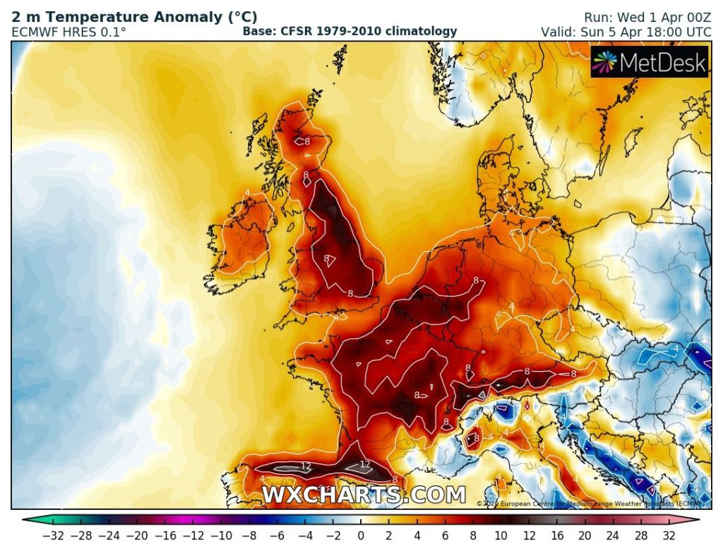
Becoming Warmer – Thursday 2nd April 2020 – Sunday 5th April 2020

Hi all,

First month of Spring done, and the last week or so of it spent in ‘lockdown’. Since we’ve been limited to one form of exercise a day and confined to work and home, the weather has settled down and we’ve only had measurable rain fall once in 9 days. No surprise!

After some warm sunshine last week we’ve been back to cloudier skies and colder conditions recently, especially in the wind. We actually had 7 nights of ground-frost last week too (lowest grass temperature being -4.5°C). The rain/wind was looking likely to return this weekend and turn unsettled but now it’s not looking so bad and with a couple of warmer days ahead too. The sun is now as strong as the first week in September. UV levels are now 3-4, which in fact isn’t that strong but still good enough to start a tan if you bask in some sunny periods.

Thursday: Showers moving southeast then turning a little brighter but very windy and feeling quite cold for the time of year. Max 9°C

Friday: Not as windy and a cold start with a touch of ground-frost. Sunny spells and the odd shower. Temperatures still below normal. Max 9°C

Weekend: Becoming warmer but windy

Temperatures rising nicely above average later this weekend

Saturday: Sunny spells and windy. Turning milder throughout the day and staying dry. Max 13°C

Sunday: Sunny spells and windy. A gusty but warm southerly airflow. Cloud thickening later with some rain overnight. Temperatures well above average. Max 17°C

Outlook: A couple more days of sunny spells, after some early rain on Monday. Not as warm as Sunday but still pleasant enough. A little cooler and perhaps unsettled later in the week.

March 2020 Stats

Max 17.4°C (25th)
Min -1.9°C (6th)
Av. 6.2°C
Av. Dew Pt 2.1°C
Wettest 18.8mm (9th)
Av. Humidity 76%
Av. Barometer 1016.7 hPa
Max Gust 47.2mph (11th)
Av. Wind Direction WSW
Rain 74mm
Rain Registered Days 15
Dry Days 16
Air Frosts 2

Follow @ChadWeather on Twitter for the latest weather forecasts.

Thanks,
Jon

Forecast Issued: Wednesday the 1st of April 2020 at 7:15pm

Turning Much Colder – Thursday 26th March 2020 – Sunday 29th March 2020

Hi all,

What a surprise, our weather turned lovely with warm sunny spells and we can’t venture out to enjoy it fully. I hope you are all well and keeping sane during these surreal times. As we know, warm, sunny weather doesn’t always last in this country.

Thursday: A frosty start but temperatures soon rising and another beautiful sunny day ahead. It won’t be as warm as recently as the wind will have shifted to a cooler direction, the north-east. Max 13°C although a little higher in sheltered, western spots.

Friday: Frosty to start (for the early risers). Slightly cooler again and the breeze beginning to pick up. Another, the last one, sunny day. Max 11°C

Weekend: Big shock on the way.

Saturday: A cloudier day with a few bright spells. It should remain dry but a huge difference in the feel of the weather. A north-easterly wind becoming gusty. COLDER! Max 8°C

Sunday: Even colder with a raw north to north-easterly wind which will be brisk. This could drag a few wintry showers in and some may fall as hail, sleet or snow. The showers are expected to be scattered and not that heavy. Max 6°C

Outlook: A lot of dry weather around as high pressure stays close. However, it looks set to stay cold, with temperatures in single-figures. Later in the week some wintry showers can’t be ruled out again, so we could see some sleet/snow showers to start April. It might be unseasonably cold but it certainly beats wind and heavy rain.

Follow @ChadWeather on Twitter for the latest forecasts.

Thanks,
Jon

Forecast Issued: Wednesday 25th of March 2020 at 4:25pm.

Better Weather on the Horizon – Thursday 12th March 2020 – Sunday 15th March 2020

Hi all,

Yet more rain recently, but it looks like next week will finally see a change to the position of the Jet Stream, meaning more in the way of settled weather with sunny spells and some dry days! Hard to believe I know!

Thursday: Breezy with sunny spells and a few wintry showers, falling as hail, sleet and snow. Cold. Max 8°C

Friday: Cloudy to start with some showery rain. This soon clearing to a drier day with bright spells, lighter winds and just the odd shower into the evening. Max 8°C

Weekend: Saturday the drier day.

Saturday: Milder, mostly dry and cloudy. Can’t rule out some hill-drizzle. Windy especially later. Max 10°C

Sunday: Rain followed by bright spells and showers, windy. Max 9°C

Outlook: Good news. It’s looking favourable that high pressure builds, so as next week progresses (some uncertainty on timings), we’ll hopefully see dry conditions for several days with pleasant Spring sunshine and temperatures rising a touch. 

Follow @ChadWeather on Twitter for the latest forecasts.

Thanks,
Jon

Forecast Issued: Wednesday the 11th of March 2020 at 2:10pm