Hi all,
It’s back to the normal British winter. No snow or proper cold in the next 7 days.
Thursday: A few bright spells during the morning but some showers, perhaps heavy and thundery, will arrive into the afternoon and last into the evening. Max 8°C
Friday: A reasonable day. Light winds, some sunny spells and mostly places escaping with a dry day. A touch cooler. Max 7°C
Weekend: Milder with some rain.
Saturday: A dry start but cloud thickening with some outbreaks of rain and drizzle, especially on higher ground, arriving from the southwest. Turning milder. Max 10°C
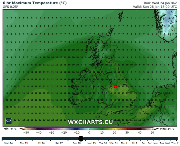
Perhaps a 13°C in some spots on Sunday
Sunday: Cloudy and dull with some patchy light rain and drizzle. Some areas sheltered from the southwesterly wind will remain dry. Much milder with a fresh breeze. Max 12°C
Outlook: A trend towards slightly less mild conditions as we enter February. It looks like we will settle down a touch too, with high pressure close by. No sign of anything particularly cold or snowy but a chance of a few slight frosts.
Follow @ChadWeather on Twitter for the latest forecasts.
Thanks,
Jon
Forecast Issued at 13:15 on Wednesday the 24th of January 2018
Image: http://wxcharts.eu/