Thursday 19th April 2018 – Sunday 22nd April 2018

Hi,

As promised in last week’s blog, sunnier and warmer weather is coming, bringing us our first taste of summer. I also mentioned that it was set to break over the weekend and this is still the case. This is the time where gardens grow so fast you’ll have to give in and finally cut the lawn and perhaps you sneak in the first BBQ of the season.

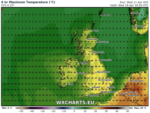
Thursday: Breezy but a lovely day with sunny spells and very warm. Warmest day of the year so far. Dry. Max 22°C

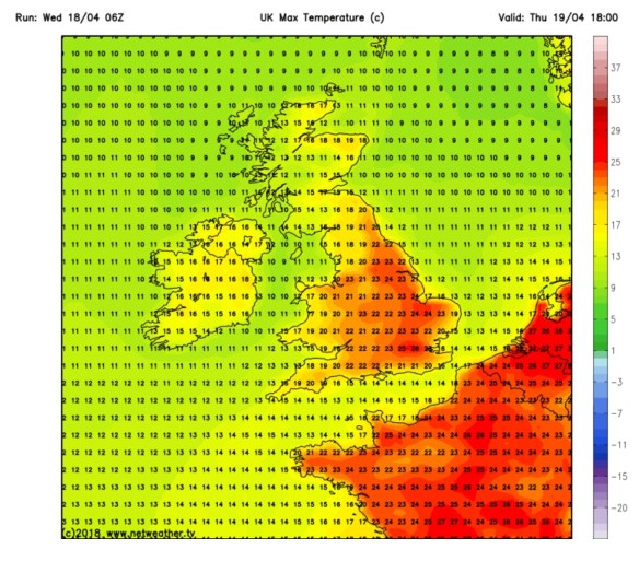
Thursday will be the warmest day of the year so far

Friday: A misty start in places but another nice day with sunny spells. We lose the warm southeasterly wind direction for today and switch westerly meaning it will be a cooler. Max 17°C

Weekend: Saturday’s best.

Saturday: Little change during the day. Sunny spells, very warm and pleasant. Cloud will bubble up though and there is a chance of showers breaking out into the evening as high pressure slips away. Max 19°C

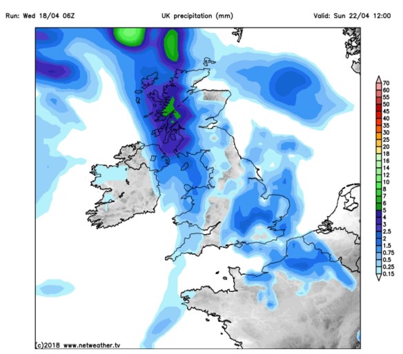
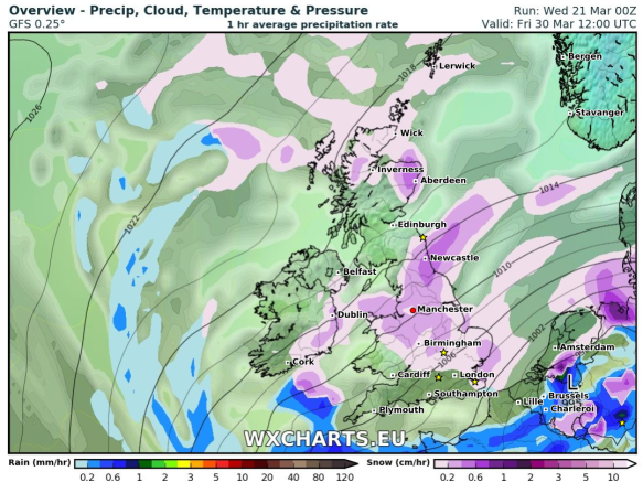
Showers possible later on Saturday becoming more widespread and perhaps thundery on Sunday

Sunday: The breakdown arrives with heavy, perhaps thundery showers spreading in from the west. Cooler. Max 16°C

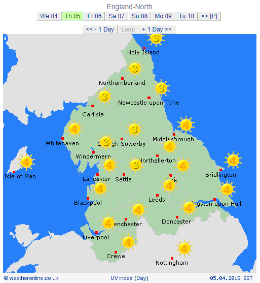
Throughout the period UV levels will be between 4-5 and the sun is as strong as late-August. So don’t forget your sun-cream if you’re out in it for a long period of time.

Outlook: All change as our weather starts to come in from the Atlantic again. So, cooler, cloudier and eventually wet with rain at times. Temperatures back into the teens. So make sure you enjoy this warm spell.

Follow @ChadWeather on Twitter for the latest weather forecasts.

Thanks,
Jon

Forecast Issued on Wednesday the 18th of April 2018 at 2:10pm.
Images: https://www.netweather.tv

Thursday 12th April 2018 – Sunday 15th April 2018

Hi all,

Finally some warmer weather on the horizon. This time next week I might have dug the shorts out and be planning a BBQ. Of course this is all down to the forecast panning out as planned over the next 6-8 days. We deserve something settled, sunny and warm so fingers crossed.

Thursday: A mostly cloudy day with a cool easterly breeze still affecting the region. This might drag in some drizzle or light rain at times, especially during the morning. Cold. Max 9°C

Friday: Little change. Hopefully less in the way of drizzle and some brightness breaking through here and there as we enter the afternoon. A touch less cold. Max 12°C

Weekend: Mostly dry, slowly warmer.

Saturday: Dry but mostly cloudy,  thickest the further west you are. Just a chance of some isolated patchy drizzle for the morning. Milder. Max 14°C

Sunday: Bright spells and again most areas dry. Southerly winds helping to lift the temperature and we should see some warm sunny spells late in the day. Max 16°C

Temps Wed

Temperatures up to 20°C by Wednesday next week

Outlook: High pressure building and dragging warmer air up from the south/southeast. Cloudier and breezier in western areas otherwise sunny spells and warming up nicely. I’m not promising wall-to-wall sunshine but more so sunny intervals. UV levels in the sunshine up to 4/5, so time to work on your tan and sun-cream routine. We could well sneak a 20°C by midweek and see our warmest weather since August 2017, if we beat 20.2°C. How long will it last? This warm spell looks set to break over the weekend.

Forecast issued at 9:45am on Wednesday the 11th of April 2018.
Images: http://wxcharts.eu

Thanks,
Jon

Thursday 5th April 2018 – Sunday 8th April 2018

Hi all,

Winter has had a final few bites at us over the past few weeks, with some snowfalls and the bitter wind from the ‘Beast from the East 2’. We even managed snow on Easter Sunday, but don’t be surprised. Snow at Easter is more likely than snow at Christmas. March overall was a colder-than-average month but much drier than normal. It did actually rain on 23 days of the 31, but amounts were small. Is that the last of the snow? Yes, I think so.

UV Levels 04-04-2018

UV levels up to 3 and 4 on Thursday. Time to soak up the sun’s rays.


Thursday:
A cold and frosty start for some, but a lovely day ahead with pleasant sunny spells. Dare I say it, UV levels are now up to 3-4 which means you will catch the sun if you’re out in it for a few hours and we’ll soon we talking about sun-cream again! Max 11°C

Friday: A dry morning with sunny spells. Cloud increasing into the afternoon with rain arriving after dark. Milder as winds increase and drag up air from the southwest. Max 13°C

Saturday: Cloudy with some rain but this should ease away during the day with some bright spells developing later on. A few evening showers are possible. Max 12°C

Sunday: A mostly overcast day but some sunny spells developing later and it should be mostly dry. Any decent sunny spells will lift the temperatures quickly. Max 13°C

Outlook: A cloudy set-up and quite cool. Perhaps signs of something a little warmer past mid-month. Sooner or later a decent Spring spell will arrive.

Follow @ChadWeather on Twitter for the latest forecasts.

March 2018 Stats

Max 13.7°C (10th)
Min -5.9°C (1st)
Av. 4.4°C (colder than average)
Wettest 8.2mm
Windiest 47mph
Rain 51.8mm (57% of average)
Rainy Days 23
Dry Days 8
Air Frosts 8 (more than average)
Snow Falling Days 4
Snow Lying Days 6

Thanks,
Jon

Forecast Issued at 5pm on Wednesday the 4th of April 2018.
Image: http://weatheronline.co.uk


Thursday 22nd March 2018 – Sunday 25th March 2018

Hi all,

Last week we discussed the ‘Beast from the East 2’, the sequel etc. and it certainly delivered. To be honest the amount of snow it brought even surprised me. The wind was also a feature bringing a severe wind-chill and snow drifts up to 4 feet high. It was only a short-lived affair, basically freezing us for the weekend and it wasn’t as intense as the previous Beast, but it was certainly impressive for the second half of March. Of course the media have jumped on this opportuinity to say number 3 is coming and we will see snow at Easter, but what is the realistic outlook?

‘Beast from the East 2’ Stats

  • The temperature dropped 6°C in 90 mins as colder conditions arrived on Friday
  • Snow fell most of Saturday afternoon and overnight
  • Widely 8cm of snow-cover
  • Snow drifts up to 4ft
  • Many road closures
  • Lowest wind-chill of -10°C
  • Lowest feels-like temperature of -11°C
  • Sunday didn’t see the temperature rise above freezing
  • Wind gusts of 50mph locally and especially on the hills felling some trees
Temp drop Beast 2

A rapid temperature drop as the ‘Beast from the East 2’ arrived last Friday

Thursday: Sunny spells and southwesterly winds freshening. It should remain dry until later in the evening and overnight when rain will arrive. Max 9°C

Friday: Early rain, some heavy clearing during the morning. Bright spells into the afternoon with a few showers, possibly thundery. Cool and breezy. Max 10°C

Weekend: Not bad at all, no dramas like last weekend.

Saturday: Apart from the odd shower it looks a reasonable day with sunny spells. Max 9°C

Sunday: A misty start, soon lifting to sunny spells and the odd rogue shower. With light winds it will feel pleasant in any sunshine. Max 10°C

Cold NE

Colder with a chance of snow showers by the time we get to Good Friday

Outlook: Remaining mild with temperatures close to double-figures. Some rain at times, especially into Tuesday, but brighter spells too. As we approach Easter the computer models are showing signs of a cold wind developing again. This looks to be from the northwest or north, but some signs are there for a northeasterly. This will bring lower temperatures and with it the risk of some wintry showers and snow. This looks to last 2-3 days, and yes you’ve guessed it, starting on Good Friday. So, at this current stage, no Beast from the East 3 exactly, but definitely not the Easter forecast you wanted to hear.

Follow @ChadWeather on Twitter for the latest weather forecasts.

Thanks,
Jon

Forecast Issued at 10:30am on Wednesday the 21st of March 2018
Image: wxcharts.eu


Thursday 15th March 2018 – Sunday 18th March 2018

Hi all,

Beast from the East 2. The sequel. Snow until Easter. I’ve heard it all this week. There’s some truth in those headlines and with it a disappointing outlook as Spring seems to be on hold.

Thursday: Mostly cloudy and windy across the region but with it some mild temperatures. Rain will be coming up from the south but will turn patchy at times and eventually fizzle out with hopefully some late-afternoon brightness. Max 9°C

Friday: Another cloudy and windy day with some showery rain at times, mainly in eastern areas. Feeling a little cooler too, especially later with a chance that some of the rain could turn to sleet or snow on the hills as colder air arrives. Max 7°C

Weekend: Bitterly cold, windy.

Saturday: A strong easterly wind feeding in much colder conditions. Gusts to 40mph likely. A similar pattern to when we had the Beast From the East but not as cold/snowy and it will not last as long. During the day some light snow showers could develop, but at this stage no significant snow is expected. Temperatures struggling above freezing with a severe wind-chill for the time of year making it feel like -5°CMax 2°C

Sunday: Remaining very cold with those biting winds from the east. Any snow flurries or showers tending to fade as the supply from the east gets cut off as high pressure builds. Max 3°C

Outlook: After a very cold 2-day spell over the weekend, it will become less cold but the search for anything Spring-like continues, with temperatures expected to remain below average throughout the next 5 days.

Follow @ChadWeather on Twitter for the latest weather forecasts.

Forecast Issued on Wednesday the 14th of March 2018 at 1:45pm.

Thanks,
Jon

Thursday 8th March 2018 – Sunday 11th March 2018

Hi all,

Well what a week that was. The ‘Beast From the East‘ certainly delivered. The official snow depth here was 12cm on the 1st of March and we had many days of snowfall, severe wind-chill, travel disruption and then very strong winds gusting locally to 55mph. Of course, weather-wise, we’re now into Spring and we say goodbye to Winter 2017-18, which turned out the ‘snowiest’ I’ve ever recorded since my records began in late-2012.

Extremes Recorded during the Beast From the East – all new records

Lowest Temp= -6.1°C (28th Feb)
Lowest Wind-chill= -12.0°C (1st Mar)
Lowest Apparent Temp= -12.1°C (1st Mar)
Lowest ‘Feels Like’ Temp = -13.3°C (1st Mar)
Lowest Daytime Max Temp= -2.4°C (28th Feb)

But the Lowest Dew Point record of -12.7°C, from the 25th of March 2017, remained intact.

Here’s how previous winters have compared.

Winter Stats

Comparing the last 6 winters


So can we expect something warmer and Spring-like soon?

Thursday: A cloudy damp start with some rain, sleet and hill-snow. Some settling snow is possible above 250M (2+cm), and especially so over the Pennines (5+cm), so check the roads if you’re travelling trans-Pennine routes. At the time of this blog there is a warning in place. This should all clear mid-morning with bright spells and showers following. Some of the showers heavy, perhaps wintry with hail and thunder. Max 6°C

Friday: We will start with a slight frost and some ice in places. Not a bad day in store with sunny spells and dry. Feeling pleasant in the sunshine. Cloudier later with rain overnight. Max 7°C

Weekend: Wet then drier; Sunday the better day

Saturday: A keen southeasterly wind. Rain, some heavy,  lasting most of the day. Just a few drier slots at times. Early on, there is a slight chance of some snow on the Pennines for a few hours but this is a low risk as it will get progressively milder. Max 9°C

Sunday: Yesterday’s rain clears quickly to leave a drier day with variable cloud allowing for some sunny spells here and there. Mild and it will be the first time we have reached double-figure temperatures since the end of January. Max 11°C

Outlook: Slighly cooler after Sunday with some showers at times which could be wintry. Milder later in the week with southwesterly winds dominating.

February 2018 Stats

Max 9.7°C (19th)
Min -6.1°C (28th)
Av. 2.5°C (colder than average)
Wettest 11.8mm
Windiest 44mph
Rain 60.8mm (drier than average)
Rainy Days 16
Dry Days 12
Air Frosts 14 (more than average)
Snow Falling Days 10
Snow Lying Days 6

Follow @ChadWeather on Twitter for the very latest weather updates.

Thanks,
Jon

Forecast Issued: Wednesday the 7th of March 2018 at 5pm.

Thursday 15th February 2018 – Sunday 18th February 2018

Hi,

Only a couple of weeks left of winter and recently we’ve felt its presence with some more snowfall and cold temperatures, but, change is on the way. However, don’t be thinking of putting away those thick coats just yet, as winter might not be done with, after the recent Sudden Stratospheric Warming event.

Thursday: A reasonable day with some bright spells and milder than recently. There will be the odd wintry shower and a fresh breeze. Max 7°C

Friday: Dry with sunny spells and feeling pleasant. Max 8°C

Weekend: Mostly dry with light winds as pressure builds.

Saturday and Sunday: Mostly cloudy with some bright spells. Feeling quite mild. Just the risk of some drizzle in any thicker cloud, especially on hilltops. Max 9-10°C

HP

High pressure in charge next week so a lot of overdue drier weather on the way

Outlook: High pressure in charge and at first the position of the high will lead to mild and settled conditions. As the week progresses the high could well slip north and introduce cold, then very cold, easterly winds. Initially the focus will be on it feeling bitter but with a lot of dry and overcast weather.

Follow @ChadWeather on Twitter for your latest weather forecasts.

Thanks,
Jon

Forecast Issued at 13:45 on Wednesday 14th February 2018
Image: http://wxcharts.eu

Thursday 8th February 2018 – Sunday 11th February 2018

Hi all,

What a shame (some of you won’t agree) that we had the perfect subzero temperatures for snow on Tuesday but the band of snow that pushed in from the northwest was only light. Even after 6 hours of continous light snowfall it hardly settled and the amounts were minimal. Ah well. Next please……

Thursday: Cloudy with patchy rain slowly arriving during the late-afternoon and evening and becoming much milder for a time. Overnight a spell of more heavier rain as a cold front comes through. Max 7°C

Friday: We return to the colder air filtering down from the northwest. With it some wintry showers so expect hail, sleet, some snow and even thunder and lightning. There could be a prolonged spell of showers during mid-morning. It should turn drier during the afternoon. Max 5°C

Weekend: Unsettled and turning colder.

Wintry showers with snow on Sunday

Wintry showers on Sunday as we turn colder

Saturday: A cold start then becoming cloudy with rain arriving and becoming quite windy. The rain could start off as sleet or snow above 250M but it won’t last too long. Max 7°C

Sunday: Back to square one. Colder with wintry showers, again heavy and possibly thundery. The showers will give a covering of snow in places, especially above 200M. Feeling bitter with a cold northwesterly wind. Max 5°C

Outlook: Remaining cold and changeable. A risk of some windier spells and when they come along it will be briefly milder.

January 2018

Max 12.1°C (24th)
Min -0.7°C (20th)
Av. 4.4°C
Wettest 18mm
Windiest 52mph
Rain 133.2mm
Rainy Days 24
Dry Days 7
Air Frosts 2
Snow Falling Days 6
Snow Lying Days 4

Follow @ChadWeather on Twitter for the very latest weather updates.

Thanks,
Jon

Forecast Issued: Wednesday the 7th of February 2018 at 11am.
Images: http://wxcharts.eu

Thursday 1st February 2018 – Sunday 4th February 2018

Hi all,

January is coming to a close and with just a month left of winter, who’s looking forward to Spring and those lighter mornings and evenings? I know I am, but I’m still hoping for some more snow before we get there.

Thursday: Cold with bright or sunny spells and windy. Just the chance of an isolated wintry shower during the morning mainly in western areas. Max 5°C

Friday: A cold and frosty start then a reasonable day with sunny spells and a chilly wind. Cloudier later in the day. Max 5°C

Weekend: Chance of snow

Rain arriving from the west on Saturday could turn to snow

Saturday: A very cold day. Cloudy with rain pushing in from the west. Snow is possible on higher ground (mostly >200M) but not exclusively. So, with a chance of snow to lower-levels, watch out for updates on Twitter. Later into the evening we return to a few wintry showers. Max 3°C

Sunday: A return to the brighter weather with a cold wind and sunny spells. The odd wintry shower possible in eastern areas. Max 5°C

Outlook: Remaining cold throughout with bright spells, slight frosts and some wintry showers. Tuesday/Wednesday could see a band of rain which could turn to snow in places. One to watch.

Follow @ChadWeather on Twitter for the latest forecasts.

Thanks,
Jon

Forecast Issued: Wednesday the 31st of January 2018 at 7:15pm
Image: www.theweatheroutlook.com

Thursday 25th January 2018 – Sunday 28th January 2018

Hi all,

It’s back to the normal British winter. No snow or proper cold in the next 7 days.

Thursday: A few bright spells during the morning but some showers, perhaps heavy and thundery, will arrive into the afternoon and last into the evening. Max 8°C

Friday: A reasonable day. Light winds, some sunny spells and mostly places escaping with a dry day. A touch cooler. Max 7°C

Weekend: Milder with some rain.

Saturday: A dry start but cloud thickening with some outbreaks of rain and drizzle, especially on higher ground, arriving from the southwest. Turning milder. Max 10°C

Mild

Perhaps a 13°C in some spots on Sunday

Sunday: Cloudy and dull with some patchy light rain and drizzle. Some areas sheltered from the southwesterly wind will remain dry. Much milder with a fresh breeze. Max 12°C

Outlook: A trend towards slightly less mild conditions as we enter February. It looks like we will settle down a touch too, with high pressure close by. No sign of anything particularly cold or snowy but a chance of a few slight frosts.

Follow @ChadWeather on Twitter for the latest forecasts.

Thanks,
Jon

Forecast Issued at 13:15 on Wednesday the 24th of January 2018
Image: http://wxcharts.eu/