Thursday 11th February 2016 – Sunday 14th February 2016

Hello again,

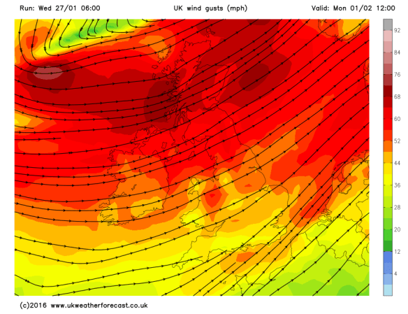
Another week has gone by and more rain has fallen across the region. In fact, Monday (8th Feb) was the 4th wettest day since my records began here in August 2012, with 31.4mm of rain recorded. This all came from Storm Imogen which brought almost 100mph gusts to the south coast. Although we didn’t feel much impact from the winds [41mph recorded Monday night] it never stopped raining.

All this wet weather led BBC Radio Manchester to get in touch, as they had a feature on the show this morning (10th) regarding the non-stop wet weather we have been having. I was unable to attend as I was on the school run but it did give me the opportunity to dig out some statistics for them.

  • We are today (10th) likely to have our first dry day for 17 days!
  • Since November the 1st 2015 we have had 635mm (25 inches) of rain and in that time 90% of the days recorded rainfall. That’s 6mm a day on average.
  • We have only had 10 dry days since the end of October 2015.

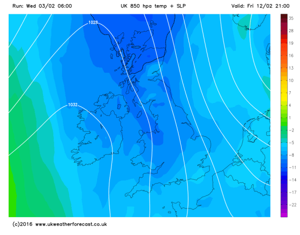
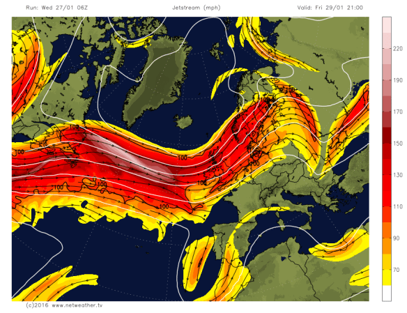
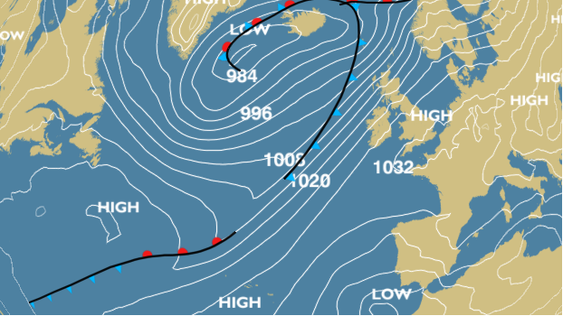
The Jet stream is now slightly further south so we are experiencing some colder air and some welcome sunny spells. Not only does it look like today will be dry, Thursday and Friday could follow suit.

Jet stream

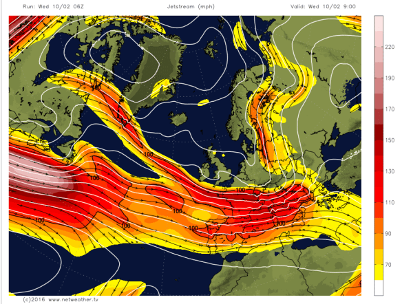
The Jet stream has dipped south into the back end of this week

A cold start to Thursday with local fog and frost, so you could be deicing before work. A mainly dry dry to follow with sunny spells and a low risk of a fleeting wintry shower. Max 6°C.

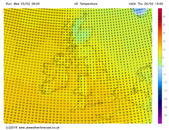
Similar on Friday, cold start, some localised frost but more cloud is expected later in the day. Beforehand, plenty of bright spells and again we should escape with a dry day. A cold easterly breeze arriving. Max 5°C.

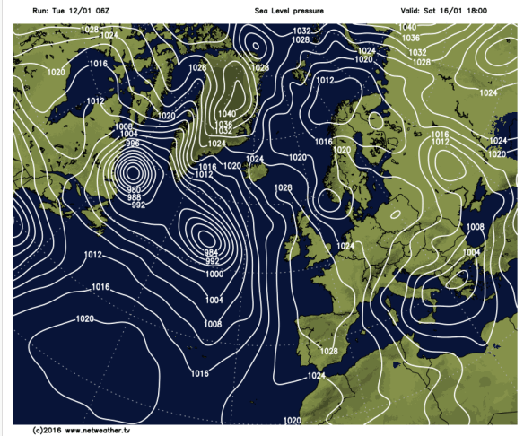
Now into the weekend, Saturday, it gets a little tricky.

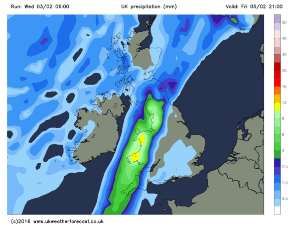
Saturday will be cold with a mainly cloudy picture across the region. There is a risk of rain coming in from the south-west, the track of this and how far north it gets is still uncertain. It could turn to snow in places as the milder air meets the cold air. My feeling is that it will stay further south but one to watch for updates via Twitter and I should know more by Thursday evening. Bitter easterly breeze. Max 4°C.

rain or snow

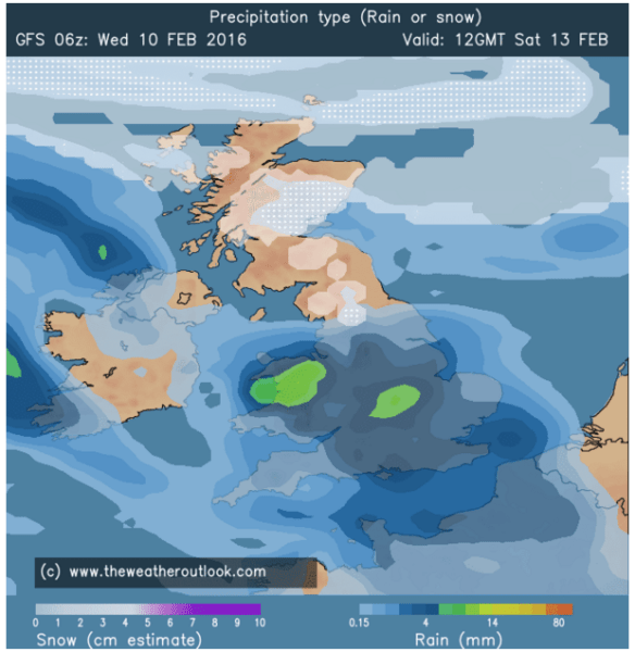
A risk of rain turing to snow on Saturday – where, is still uncertain

cold v mild

Snow could occur where the mild air meets the cold air

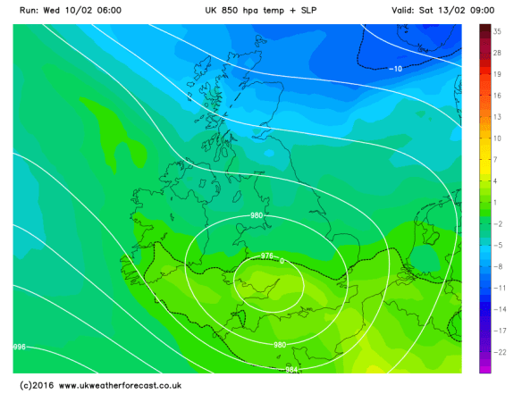
The low pressure and its mix of rain or snow moves away south into Sunday allowing the winds to switch from an easterly to an Arctic northerly bringing the risk of scattered hail, sleet or snow showers but sunny spells as well. A low windchill. Max 4°C.

Both nights over the weekend will be cold with a risk of ice and frost.

windchill

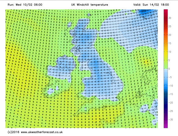
Sub-zero windchill of -5 by the end of Sunday

frosty early next week

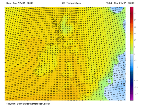
Settled, drier but frosty as we head into next week

Looking ahead and early next week sees some settled weather with sunny spells by day and cold frosty nights. Later in the week it looks likely that the winds will return to bring the Jet stream back over us and with it some wetter milder weather but there is some question mark over the timing of this. For now though, the good news is, no significant rainfall or another named-storm on the cards.

will the jet come back

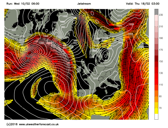
But when will that Jet stream and the wetter/milder weather return?

Remember to follow @ChadWeather on Twitter to catch all the latest weather updates for Manchester and its surrounding boroughs.

Thanks for reading,

Jon

Photos/Data: http://www.ukweatherforecast.co.uk; http://www.netweather.tv and http://www.theweatheroutlook.com

Forecast issued at 14:15 on Wednesday 10th of February 2016

Thursday 4th February 2016 – Sunday 7th February 2016

Hi all,

Two named-storms in a short period of time and even some snow showers last weekend confirms our weather remains in an unsettled state. As we enter the final meteorological winter month, I am still hopeful of some prolonged cold during mid-February and we can also always rely on March to bring us some wintry weather; so don’t put your sledges away yet.

Rain and milder conditions arrive once again on Thursday after recent cooler conditions. With this comes rain, initially heavy, but easing later on. Hill-drizzle may remain into the evening. Max 11°C.

milder thur

Max Temperatures for Thursday – back to double-figures

The flip-flop pattern continues into Friday as cooler air comes in from the north-west. This doesn’t look like arriving until later on into the late-evening, after a mainly cloudy day with some showery rain and hill-drizzle. Max 10°C.

cold front

A cold front will sink SE slowly on Friday bringing rain then cooler air

The weekend will be chilly and windy with showers at times and some cool nights. To be honest forecasting this weekend has been a bit of a headache with several what-if scenarios to deal with.

For Saturday, bright spells and some showers early on and it will feel colder than recently. Later on there is a good chance rain will spread in from the west and winds increase. Max 7°C.

Bright spells and showers on Sunday after early rain clears. If anything, maybe feeling a little cooler, especially in the fresh wind. Again, more general rain and wind later or overnight. Max 7°C.

Looking at early next week it seems to remain chilly with some showers, which could be wintry at times over the hills. The week looks breezy throughout and there is a good chance we will see some more windy weather later on; perhaps another named-storm?

named storm imogen

Another named-storm later next week – Storm Imogen?


colder

If the stormy weather comes off it could be followed by much colder Arctic air


January 2016 Stats

Av. Temp 5.3°C 
Max Temp 13.2°C (24th)
Min Temp -2.7°C (16th)
Wettest Day 13mm (27th)
Highest Gust 45mph (27th)
Rainfall 129.8mm
Rainy Days 26 

Follow @ChadWeather on Twitter to catch all the latest weather updates for Manchester and its surrounding boroughs.

Thanks for reading,

Jon

Photos/Data: http://www.ukweatherforecast.co.uk

Forecast issued at 16:30 on Wednesday 3rd of February 2016

Thursday 28th January 2016 – Sunday 31st January 2016

Hi all,

It’s wet and wild whilst I write this blog. Not dissimilar to yesterday when ex-storm Jonas, which brought parts of the U.S. 2-3 feet of snow, rattled across the UK. This is a sure sign that the Jet Stream is back in charge of our weather, depressing news for proper cold- and snow-lovers.

The next few days sees an up-and-down trend in temperatures across the region as we swing from one side of the Jet Stream to the other.

powerful jet

A powerful Jet Stream still controlling our weather

After a mostly wet, windy and mild Wednesday we sit on the cold side of the Jet Stream on Thursday. A cold start with a rural frost; so perhaps some deicing before work for some. Feeling much colder with sunny spells but cloud increases during the day with some rain or showers expected into the afternoon, some heavy. Winds will again increase; gale-force gusts overnight. Cold during daylight hours but temperatures rising again into the evening. Max 8°C.

Again it is milder into Friday but it will not feel so with very windy conditions. Gusts to 55mph in exposed places is likely, especially so during the morning. Showers at times on the westerly wind and more general rain overnight. Max 12°C.

I did say a few days ago that we won’t see any more snow in January. Saturday will be cold enough for some wintry showers so we could see some hail and possibly some sleet or snow showers in areas above 350M. Not exactly a major snow-event but a reminder that it’s winter and enough for the Met Office to issue a warning for further north. Max 5°C.

wintry showers on sat net

Wintry showers with some snow to higher ground is possible on Saturday

snow warning

Warning for snow and ice issued for Cumbria showing winter is still close by

Overnight into Sunday and it looks like rain will return from the south-west and with it milder temperatures once more. Certainly weather that can’t make its mind up. Max 11°C.

mild temps from the SW on Sun

After a colder Saturday; milder air returns from the south-west during Sunday

Looking ahead and next week could start with more gales on Monday. After that, sunshine and showers with tempertures back down into single-figures. I’m still going for a chance of some decent cold and bitter temperatures from mid-February. As always, no-one knows and this is just my hunch.

more gales on Monday

Next week starts with more gale-force gusts

Follow @ChadWeather on Twitter to catch all the latest weather updates for Manchester and its surrounding boroughs.

Photos/Data: http://www.ukweatherforecast.co.uk, http://www.metoffice.gov.uk and netweather.tv.

Thanks for reading,

Jon

Forecast issued at 14:00 on Wednesday 27th January 2016

Thursday 21st January 2016 – Sunday 24th January 2016

Hi all,

Last week’s blog stated that last weekend would be dry and sunny with severe frosts as high pressure took hold. High pressure did arrive but only briefly and the forecast was shaken up, because from Friday, a system developed to our north-west. This came south-eastwards on Saturday and brought a spell of snow for most with 4-6cms of lying snow reported. Now don’t get me wrong, I like to get a forecast bob-on but it’s very welcome to spoil my plans if it delivers some snow.

A cold and frosty start to Thursday, with some isolated freezing fog patches. Cloud soon spreads in from the west with a freshening breeze later in the day. Some rain will develop into the afternoon or evening. Slowly milder. Max 5°C.

Milder air pushing out the colder air

Milder air pushing out the cold air that we have been experiencing recently

Overnight on Thursday the winds increase with heavy rain spreading from the west. So I’m expecting Friday to be a wet and breezy during the morning with the afternoon turning a little drier with the odd shower. The big change will be the temperature. With the rain comes milder south-westerly winds and by the end of the day some areas will be close to double-figures. Max 10°C.

friday rain

Heavy rain expected during Friday morning

Saturday looks the better day of the weekend with a dry day expected with some pleasant sunny spells. Mild. Max 10°C.

More cloud is likely into Sunday with bright spells limited. Some rain possible and temperatures remain on the mild to very mild side just like we were in December. Not winter-like at all. Max 12°C.

Sunday's temps

The UK under the influence of a very mild airmass by Sunday

Looking ahead and it remains mild with temperatures above average with no sign of snow returning.

Follow @ChadWeather on Twitter to catch all the latest weather updates for Manchester and its surrounding boroughs.

Photos/Data: http://www.ukweatherforecast.co.uk

Thanks for reading,

Jon

Forecast issued at 14:00 on Wednesday 20th January 2016

Thursday 14th January 2016 – Sunday 17th January 2016

Hi all,

So at last, it feels like winter; well January at least. To me it’s not winter until we see some snow and hard frosts. So, snow, where is it, and can we expect some? A tough question to answer as we hover close to “cold-enough-to-snow-temperatures”. It has turned colder this week and some of the tops have seen a covering of snow, albeit slushy and temporary but most of our showers have continued as rain.

As promised the Jet Stream slipped south allowing colder air to feed in from the north. This will remain the case for another 5-7 days. It turns colder at the back end of this week, so the chances of seeing some snow increases and the areas it could fall in, may include lower areas, rather than just the locations above 300M.

Wednesday night sees showery rain come in from the west and as this bumps into the cold air we could see some snow especially above 300M. Therefore, Thursday will start with some rain, sleet and snow. As this moves away colder air digs in and any rain could turn to snow for a time before brighter skies and the odd wintry shower feed in. Risk of snow showers overnight, even to lower levels. Max 4°C.

Thu am snow risk

Snow risk Wednesday night into Thursday

Friday will be a day of wintry showers and bright spells. Some of these showers will be of hail and snow. Again most of any snow will be for higher ground but not exclusively. Feeling raw in a bitter wind. In fact, Thursday and Friday will have a sub-zero wind-chill. Frosty and icy night ahead as showers fade. Max 4°C.

thu and fri windchill

Bitter on Thursday and Friday with a sub-zero wind-chill

The weekend promises to be a largely dry affair as high pressure builds over the UK. This means plenty of sunshine but very cold nights with a risk of fog and widespread sharp frosts.

Saturday and Sunday look very similar. Cold frosty mornings and nights with sunny spells during the day. There could be some freezing fog slow to clear and where it lingers on, the daytime maximum temperature will not rise above zero. Staying cold throughout with night-time temperatures even as low as -8°C especially in rural spots. Daytime Maxes 3°C.

frosts

Sharp frosts this weekend


high pressure weekend

High pressure over the weekend

Looking ahead and it will remain cold to start next week but it then looks likely that milder air will return from the southwest bringing rain which might be preceded by snow for a time.

milder airflow to return

Milder air looks likely to return from midweek next week


milder temps

Perhaps temperatures will return to double-figures?


It is tricky to pinpoint snowfalls, especially when temperatures are 50/50 for snow to occur. My advice would be to keep a watch on my tweets this week for the very latest on the snow-risk.

Follow @ChadWeather on Twitter to catch all the latest weather updates for Manchester and its surrounding boroughs.

Photos/Data: http://www.ukweatherforecast.co.uk and http://www.netweather.tv

Thanks for reading,

Jon

Forecast issued at 14:00 on Tuesday 12th January 2016

Thursday 7th January 2016 – Sunday 10th January 2016

Hi all,

Happy New Year and all the best for 2016! Hopefully an interesting weather year ahead. I’m only asking for heavy snow, storms and a heatwave; shouldn’t be a problem!

After recent flooding across different parts of the UK, the weather pattern is going to change. As mentioned in the last blog, the majority of the Jet Stream is shifting south. This will allow colder air to filter down from the north and northwest. This will be more noticable into next week.

Jet Stream

Wed 13th Jan – Predicted position of the Jet Stream

You probably heard heavy rain overnight on Wednesday and this will be slow to clear on Thursday. After a wet morning it will gradually turn drier and a much better afternoon lies ahead with sunny spells. Breezy with a chance of isolated showers later. Max 7°C.

Still unsettled into Friday. Any dry start will be replaced by a band of showery rain moving from west to east. Drier into the evening and with clear spells overnight, a slight frost and some ice to watch out for. A cold day. Max 6°C.

low pressure

Low pressure in charge of the weekend’s weather

Saturday starts chilly and mainly dry. Cloud will soon thicken from the southwest with rain expected to spread across all parts leading to a wet day. Becoming breezy and feeling cold. Max 6°C.

Turning a little colder as we go through Sunday. Some rain around which might be a bit sleety over the hills. Drier later. A cold night ahead with a touch of frost possible. Max 5°C.

Looking ahead into next week and it’s looking more like it, for the cold-lovers out there, especially from midweek. Overnight frosts widespread and although it will be much drier than recent weeks we could start to see some wintry showers, so hail, sleet and some snow could be on the cards.

frosts

Widespread frosts into next week

Northerly airflow brings cold air down across the UK.

December 2015 Stats

Av. Temp 8.9°C 
Max Temp 14.4°C (19th)
Min Temp 0.8°C (13th)
Wettest Day 43mm (26th)
Highest Gust 46mph (5th)
Rainfall 197.8mm
Rainy Days 29 

Follow @ChadWeather on Twitter to catch all the latest weather updates for Manchester and its surrounding boroughs.

Thanks for reading,

Jon

Thursday 3rd December 2015 – Sunday 6th December

Hi all,

Wet wet wet. The only way to describe the last week and the month of November which turned out to be the wettest month I’ve ever recorded with 231.8mm of rain falling. The previous record was 185.4mm in December 2012.

We are now in the meteorological winter and we start December mild with more rain on the way. 

Thursday will see rain across the region. Some heavy bursts, especially on the hills with a risk of localised flooding once again. It will clear later in the evening. Mild and breezy with cooler air following on overnight. Max 11°C.

Friday promises to be the best day we’ve had for a while. We are in between weather systems so bright spells and it should remain dry albeit windy. Cooler and winds increasing overnight with gale-force gusts. Max 9°C.

It all gets a bit complicated into the weekend. 

A band of heavy rain will move in on Saturday associated with some gusty winds. It will move from NW to SE and remain very windy throughout with 60mph gusts possible. A warning is already in place. Milder for a time. Max 10°C.

Still very windy early on Sunday but easing quickly. Still quite cloudy with some rain or showers at times. Possibly brighter & drier later. Mild temperatures for December. Max 12°C.

Next week looks cooler with temperatures dropping to more typical December values.

For updates on this weekend’s possible stormy weather follow @ChadWeather on Twitter. 

Thanks for reading. 

Jon

Thursday 29th October 2015 – Sunday 1st November 2015

Hi all,

Guess what? We had some brief snow on one of the highest mountains in Scotland but what about the rest of us. Nothing of course. In fact some areas in Scotland and SE England saw 20°C this week. Not bad going that for late October.

Off Trick-or-treating or to a bonfire this weekend, then it’s not looking too bad.

Thursday will start wet with a band of heavy rain moving from west to east. The afternoon will be much better with sunny spells and drier conditions. Max 13°C.

We drag up very mild air again on Friday and after a few morning showers the afternoon should be drier but staying generally cloudy. Temperature above average. Max 16°C.

Similar to the last two days sees Saturday start cloudy with a little rain or drizzle about. This soon clears to a day of bright or sunny spells. Light winds as a ridge of high pressure builds from the south. Max 14°C.

Sunday is likely to start misty or foggy and a little chilly. Not a bad day in store with bright spells at times. Light winds and a little cooler. Max 13°C.

Next week doesn’t see much change with mostly dry weather around, some milder spells with light winds. Certainly no sign of an early winter chill.

Thanks for reading.

Jon

High pressure builds in later this weekend settling the weather down once more.

High pressure builds in later this weekend settling the weather down once more. Photo: BBC Weather.

Thursday 22nd October 2015 – Sunday 25th October 2015

Hi all,

Well would you believe it. The newspapers, sorry trash-mags, are at it again. “It’s going to snow next week”; “It’s going to be the coldest, snowiest winter for 50 years” and of course what we all want “A White Christmas”. What a load of nonsense, putting it politely. It’s nothing but guesswork and in a word ‘lies’ in order to sell papers and get everyone talking. In truth, no-one knows what this coming Winter will be like and yes I personally would love a White Christmas and several feet of snow; but all I can do is hope. There are no facts and proof that all the media stories hold any truth.

So, no snow on the horizon just yet 🙂 but what can we expect the coming 4 days and into next week.

A cloudy start to Thursday with some local drizzle or light rain around. Generally a drier picture after that with sunny spells. Feeling cooler than Wednesday with the odd afternoon shower possible. Breezy. Max 13°C.

Friday will be quite similar. A little ridge of high pressure settles things down, so bright spells and mainly dry. Just a very low risk of an isolated shower. Light winds. Max 13°C.

The weekend will not start well as a band of rain spreads in from the north-west on Saturday with some heavy bursts and gusty winds. This will sink south and leave some drizzle behind it for a few hours. Eventually drying up into the late-afternoon or evening. Gusty south-westerly winds for a time then switching back north-westerly and easing slightly. Not much difference in temperatures to previous days but it will turn cooler later on. Max 13°C.

A colder feel to Sunday with bright spells and some scattered showers. A chilly breeze across the region but looking a better day than Saturday. Temperatures down a notch. Max 11°C.

Looking ahead into next week the Atlantic is pretty much back in charge bringing spells of wet and windy weather but with sunny spells and drier interludes either side of low pressure systems.

To keep up to date with your local weather, follow @ChadWeather on Twitter.

Thanks for reading.
Jon

Thursday 15th October 2015 – Sunday 18th October 2015

Hi all,

High pressure remains in charge of our weather and is established away to our east introducing cold winds. Of course no snow, crazy media talk as usual, but some parts of Eastern Europe have seen an early snowfall. Looking ahead little change. 

A cold and possibly foggy start to Thursday with a touch of ground frost. A day of sunny spells to follow with a chance of a shower in the east. Cold breeze. Max 13°C.

Friday is likely to see more in the way of cloud and a shower or two can’t be ruled out. Again some bright spells and a cold east to northeast breeze. Max 13°C.

I wish I could promise something more interesting over the weekend but I can’t. 

Saturday and Sunday similar days. Sunny spells at times but also a lot of cloud coming in on a chilly northeasterly wind. Any cloud breaks overnight will lead to mist and fog patches and a local ground frost. Max 11-13°C.

No immediate change on the horizon (boring) but it won’t be long before the high pressure slips away and we see a more unsettled theme return. 

Follow @ChadWeather on Twitter for all your local weather updates. 

Thanks for reading. 

Jon