Thursday 31st December 2015 – Sunday 3rd January 2016

Hi,

I hope you all had a fantastic Christmas and I’d like to wish you all, the best of wishes for 2016!

What a week it’s has been. The Boxing Day floods, the continuation of crazy well-above-average mild temperatures and then a brief flirt with #StormFrank. Here’s what to expect as we see out 2015 and welcome in the New Year.

New Year’s Eve (Thursday) will have some early showers around. These move away to introduce some brief bright spells. More showers into the afternoon with some gusty winds. Feeling colder especially in the breeze and some thunder or hail in the showers can’t be ruled out. If you’re out later on celebrating, it should be drier and in fact quite cold with some ice or frost forming during the night. Max 7°C.

Cold Start to Jan 1st

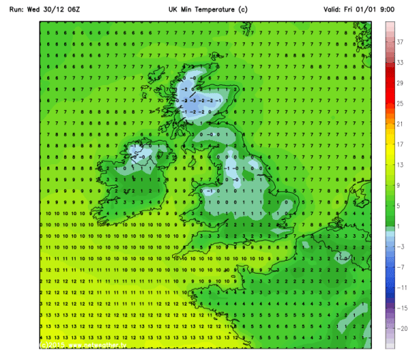
A cold and possibly icy/frosty start to January the 1st

After a cold start it looks set fair on Friday as 2016 arrives. Plenty of dry weather around during the day with bright spells and feeling much more seasonal. Winds picking up later in the day and overnight. Cold. Max 5°C.

It will feel quite chilly on Saturday with a keen southeasterly wind. It should start dry but cloudy and bands of rain are expected into the afternoon. Max 8°C.

A similar story into Sunday. Cloudy with some rain around early on. This clears and we’ll hopefully see a drier slot before another low pressure to our southwest brings a risk of rain into the evening. Its track is still uncertain so we could escape with a dry afternoon/evening. Still a fresh breeze taking a little edge off the temperatures. Max 8°C.

Jet Stream Tracks South

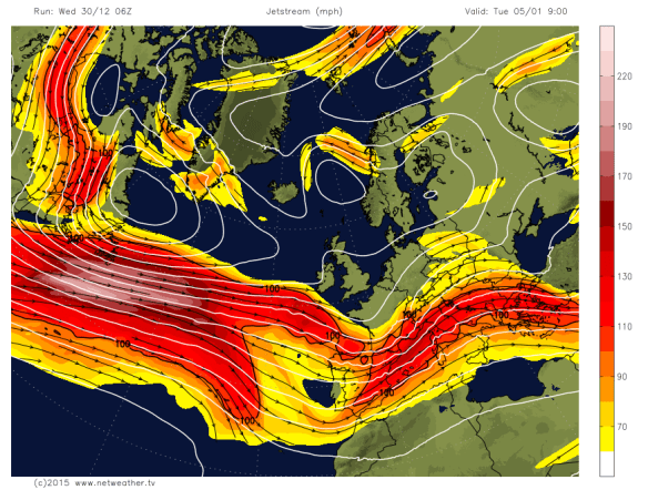
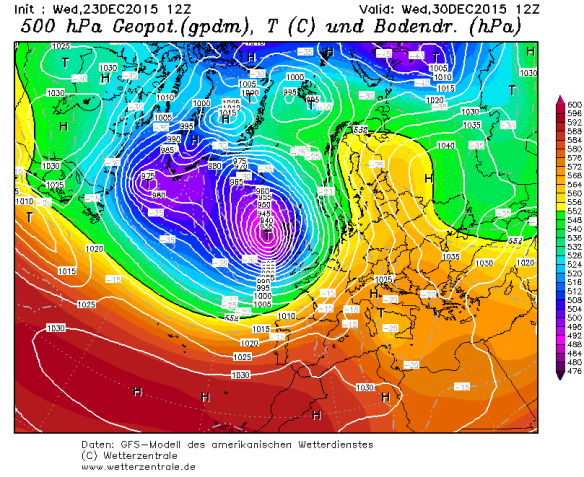
Jet Stream slips just that bit further South next week

Looking ahead into next week and the Jet Stream tracks slightly further south so it shouldn’t be as wild or as mild but still some rain or showers around. Cool too, so all-in-all a more typical feel to our weather.

Follow @ChadWeather on Twitter for all your weather updates for Manchester and its surrounding boroughs.

Thanks for reading,

Jon

Thursday 24th December 2015 – Sunday 27th December 2015

Hi all,

Firstly, I’d like to wish you all a very happy Christmas and all the best for 2016. Have a good one folks.

Now unfortunately it isn’t going to be a White Christmas as December keeps up the wet and mild theme. However, there is the possibly of some stormy weather on the way before the year is out.

It will start wet and windy on Christmas Eve as rain sweeps through from the tail-end of Storm Eva. It will be followed on by sunshine and some showers. Cooler as the day progresses.  Max 9°C.

Christmas Day will start chilly across the region with the possibility of a local ground frost. Cloud will thicken and rain will arrive during the day to give a wet afternoon and turning much milder into the evening. Max 11°C.

All eyes on Boxing Day as a band of rain could become stagnant across the northwest. It will be mild and breezy but there is concern that the rain could be persistent and heavy and introduce localised flooding but there is a chance it could linger away further north than our location. One to watch. Max 11°C.

Boxing_Day_Rain

Boxing Day rain-risk

The rain should slowly ease away on Sunday leaving a cloudy day but drier with the mild conditions continuing under southerly winds. Max 12°C.

Looking ahead to next week and there is a chance of some stormy weather after a few more mild and breezy days. The GFS computer model has an intense storm for the 30th of December which would certainly cause issues. Looking further ahead and obviously open to change, there is another storm looming on the GFS for the first day of 2016 and it is a whopper! As you know predicting this far ahead is daft, as it changes so often, but I am getting this feeling that we are in for a notable storm within the next 10 days. Hang on to your hats!

30_storm

Possible storm on the 30th?


01_storm

Even stronger storm to welcome in 2016?

To keep up to date with all your local weather then follow @ChadWeather on Twitter.

Enjoy the festive break.

Jon

Thursday 3rd December 2015 – Sunday 6th December

Hi all,

Wet wet wet. The only way to describe the last week and the month of November which turned out to be the wettest month I’ve ever recorded with 231.8mm of rain falling. The previous record was 185.4mm in December 2012.

We are now in the meteorological winter and we start December mild with more rain on the way. 

Thursday will see rain across the region. Some heavy bursts, especially on the hills with a risk of localised flooding once again. It will clear later in the evening. Mild and breezy with cooler air following on overnight. Max 11°C.

Friday promises to be the best day we’ve had for a while. We are in between weather systems so bright spells and it should remain dry albeit windy. Cooler and winds increasing overnight with gale-force gusts. Max 9°C.

It all gets a bit complicated into the weekend. 

A band of heavy rain will move in on Saturday associated with some gusty winds. It will move from NW to SE and remain very windy throughout with 60mph gusts possible. A warning is already in place. Milder for a time. Max 10°C.

Still very windy early on Sunday but easing quickly. Still quite cloudy with some rain or showers at times. Possibly brighter & drier later. Mild temperatures for December. Max 12°C.

Next week looks cooler with temperatures dropping to more typical December values.

For updates on this weekend’s possible stormy weather follow @ChadWeather on Twitter. 

Thanks for reading. 

Jon

Thursday 26th November 2015 – Sunday 29th November 2015

Hi all,

It’s still not quite winter but you wouldn’t have thought after some frost and snow during last weekend’s cold snap. So, as we approach December what can we expect?

Thursday will start fine with bright spells but some low cloud and drizzle possible in places especially towards the hills. Cloud increasing into the afternoon with some light and patchy rain expected later on. Max 9°C.

A very similar pattern on Friday. Not a bad morning but winds increasing and this time heavier rain and gusty winds arriving into the afternoon and evening. Milder for a time then colder overnight. Max 11°C.

It’s certainly déjà vu on Saturday as again the morning isn’t too bad but soon heavy rain (possible wet hill-snow for a time) and windy conditions spread across the region to give a disappointing day. Notably colder especially so with the wind. Max 7°C.

Sunday will remain cloudy with light rain likely at times but hopefully a bit drier later in the day with the odd bright spell. Milder again. Max 9°C.

Looking ahead and it’s likely to stay unsettled and mild as we go into December and the meteorological winter. No sign of anything particularly colder.

Follow @ChadWeather on Twitter for all your local weather updates. 

Thanks for reading.

Jon

Thursday 29th October 2015 – Sunday 1st November 2015

Hi all,

Guess what? We had some brief snow on one of the highest mountains in Scotland but what about the rest of us. Nothing of course. In fact some areas in Scotland and SE England saw 20°C this week. Not bad going that for late October.

Off Trick-or-treating or to a bonfire this weekend, then it’s not looking too bad.

Thursday will start wet with a band of heavy rain moving from west to east. The afternoon will be much better with sunny spells and drier conditions. Max 13°C.

We drag up very mild air again on Friday and after a few morning showers the afternoon should be drier but staying generally cloudy. Temperature above average. Max 16°C.

Similar to the last two days sees Saturday start cloudy with a little rain or drizzle about. This soon clears to a day of bright or sunny spells. Light winds as a ridge of high pressure builds from the south. Max 14°C.

Sunday is likely to start misty or foggy and a little chilly. Not a bad day in store with bright spells at times. Light winds and a little cooler. Max 13°C.

Next week doesn’t see much change with mostly dry weather around, some milder spells with light winds. Certainly no sign of an early winter chill.

Thanks for reading.

Jon

High pressure builds in later this weekend settling the weather down once more.

High pressure builds in later this weekend settling the weather down once more. Photo: BBC Weather.

Thursday 22nd October 2015 – Sunday 25th October 2015

Hi all,

Well would you believe it. The newspapers, sorry trash-mags, are at it again. “It’s going to snow next week”; “It’s going to be the coldest, snowiest winter for 50 years” and of course what we all want “A White Christmas”. What a load of nonsense, putting it politely. It’s nothing but guesswork and in a word ‘lies’ in order to sell papers and get everyone talking. In truth, no-one knows what this coming Winter will be like and yes I personally would love a White Christmas and several feet of snow; but all I can do is hope. There are no facts and proof that all the media stories hold any truth.

So, no snow on the horizon just yet 🙂 but what can we expect the coming 4 days and into next week.

A cloudy start to Thursday with some local drizzle or light rain around. Generally a drier picture after that with sunny spells. Feeling cooler than Wednesday with the odd afternoon shower possible. Breezy. Max 13°C.

Friday will be quite similar. A little ridge of high pressure settles things down, so bright spells and mainly dry. Just a very low risk of an isolated shower. Light winds. Max 13°C.

The weekend will not start well as a band of rain spreads in from the north-west on Saturday with some heavy bursts and gusty winds. This will sink south and leave some drizzle behind it for a few hours. Eventually drying up into the late-afternoon or evening. Gusty south-westerly winds for a time then switching back north-westerly and easing slightly. Not much difference in temperatures to previous days but it will turn cooler later on. Max 13°C.

A colder feel to Sunday with bright spells and some scattered showers. A chilly breeze across the region but looking a better day than Saturday. Temperatures down a notch. Max 11°C.

Looking ahead into next week the Atlantic is pretty much back in charge bringing spells of wet and windy weather but with sunny spells and drier interludes either side of low pressure systems.

To keep up to date with your local weather, follow @ChadWeather on Twitter.

Thanks for reading.
Jon

Thursday 15th October 2015 – Sunday 18th October 2015

Hi all,

High pressure remains in charge of our weather and is established away to our east introducing cold winds. Of course no snow, crazy media talk as usual, but some parts of Eastern Europe have seen an early snowfall. Looking ahead little change. 

A cold and possibly foggy start to Thursday with a touch of ground frost. A day of sunny spells to follow with a chance of a shower in the east. Cold breeze. Max 13°C.

Friday is likely to see more in the way of cloud and a shower or two can’t be ruled out. Again some bright spells and a cold east to northeast breeze. Max 13°C.

I wish I could promise something more interesting over the weekend but I can’t. 

Saturday and Sunday similar days. Sunny spells at times but also a lot of cloud coming in on a chilly northeasterly wind. Any cloud breaks overnight will lead to mist and fog patches and a local ground frost. Max 11-13°C.

No immediate change on the horizon (boring) but it won’t be long before the high pressure slips away and we see a more unsettled theme return. 

Follow @ChadWeather on Twitter for all your local weather updates. 

Thanks for reading. 

Jon

Thursday 8th October 2015 – Sunday 11th October 2015

Hi all,

After a lengthy settled spell, some autumnal conditions returned earlier this week but as we enter this forecast period, high pressure slips over the UK. A lot of media have been banging on about ex-hurricane Joaquin racing across the Atlantic towards the UK. At this moment, the deep area of low pressure is likely to dart towards France and northern Spain, so not affecting the UK. 

After a muggy few days it’s now cooler and fresher and this will be felt on Thursday with a chilly start with local ground frost. A reasonable day follows with sunny spells and mainly dry. Low risk of a shower. Max 15°C.

The nice weather continues on Friday with it being dry with plenty of bright spells. Light winds as well so not feeling too bad. Max 15°C.

Mainly dry weather over the weekend but cloud amounts will be variable and a cool breeze from the east will pick up.

Saturday will be bright after a cold start with some mist or fog patches slow to clear. Feeling fresh in the afternoon breeze. Showers or rain could sneak in from the east overnight especially over the hillier areas. Max 14°C.

Sunday brings bright spells and turning dry after some early showers. Again a cool breeze. Max 14°C.

Looking ahead it seems the high pressure will stay close by keeping it mainly dry with bright spells. If Joaquin changes path then so will next week’s forecast, so keep your eye on Twitter.

September 2015 Stats: Warmest 20.5°C; Coldest 5.8°C; Wettest 16.8mm; Windiest 28mph; Total Rainfall 46mm.
To keep up to date with your local weather, follow @ChadWeather on Twitter.

Thanks,
Jon

Thursday 24th September 2015 – Sunday 27th September 2015

Hello all,

Not much going on lately on the weather front and we look to end the month on a static note. It’s likely October will provide a more lively autumnal feel. 

Thursday will be a breezy day across the region with showers. Some of these possibly heavy with a rumble of thunder. These showers become more scattered later in the day. Feeling cool. Max 14°C.

High pressure starts to build from the southwest into Friday. This will give us a day of bright spells after some early showers. Max 14°C.

The high pressure centres itself over the country over the weekend so plenty of dry weather. 

A chilly start to Saturday with local mist or fog patches. A day of sunny spells to follow and dry. Pleasant in the sunshine. Max 15°C.

Not much change into Sunday. Some of the mist/fog might be slow to clear in some places and lift into low cloud. Bright spells and again dry. Max 16°C but cooler where low cloud persists. 

Into next week it looks like the high pressure stays put bringing dry bright days and cold nights where skies remain clear. These clear skies will also bring the risk of mist, fog and ground frost. Temperatures should pick up slightly during the week. Later in the week there is some uncertainty whether the Jet Stream takes control and the settled weather gives way to showers or longer spells of rain. Only time will tell. 

Follow @ChadWeather on Twitter for all your local weather updates.

Thanks for reading. 

Jon

Thursday 10th September 2015 – Sunday 13th September 2015

Hi all,

We have been enjoying a decent spell of weather lately with light winds, pleasant sunny spells and more importantly dry. A couple more days to come but then the change to a more usual September pattern will begin.

Possibly a cloudy start to Thursday but with the breeze from a south-easterly direction we will drag in some drier air which will aid cloud breakages and more sunshine will follow. Plenty of sunshine arriving and although we will have a breeze it will feel warm. Max 20’C.

A similar day for Friday but a blustery wind. Remaining dry, plenty of sunshine and again we’ll see pleasant temperatures. Max 20’C

The weekend can only mean one thing. Rain returns.

A disappointing day on Saturday as we lose the dry and sunny weather. Rain spreads in from the west on a cool breeze with heavy showers following on behind. Max 17’C.

Sunday shouldn’t be too bad for most of the day. Bright spells and the odd shower during the day. However, more rain is due later in the day with breezy conditions. Cool. Max 16’C.

Looking ahead to next week and with the Jet Stream positioning itself back over us we can expect bands of showery rain throughout the week, as well as a cool and breezy set-up (see image, source http://www.ukweatherforecast.co.uk).

Low pressure and rain expected into next week.

To keep in touch with your local weather, follow @ChadWeather on Twitter.

Thanks for reading.

Jon