Thursday 5th January 2017 – Sunday 8th January 2017

Hi all,

Happy New Year and all the best for 2017.

The media have been at it again with their annual, or is it now weekly, lies about a Killer Freeze on the way with record low temperatures and more snow than we’ve ever seen before. 

Unfortunately some folk, especially the vulnerable still believe this tripe, so spread the word, never believe their headlines. I’ll be the first to let you know, if we are due any snow and plummeting temperatures. 

Thursday: A very cold and frosty start with temperatures of -4°C in some parts. A lovely, crisp winter’s day follows with plenty of sunshine. Make the most of it as all change ahead. Max 3°C

Fronts coming in from the west bring rain and milder air on Friday

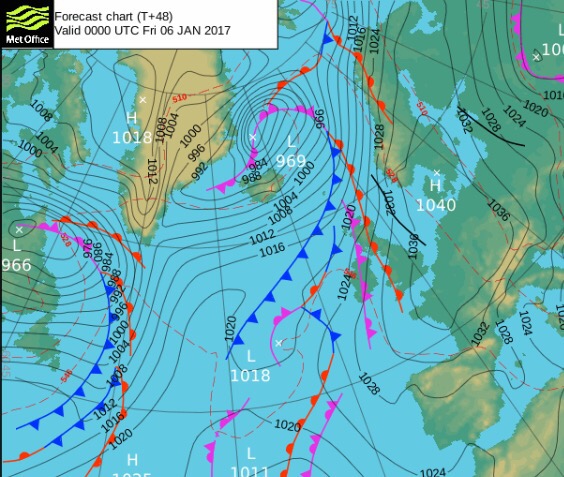
Friday: Cloudy with rain coming in slowly from the west. Some of the rain will be heavy. A cold-feeling day but temperatures on the rise. Max 8°C

Not much sunshine at the weekend but not a washout. 

Saturday: A mild start with some fog and low-cloud over the hills. The latter could persist all day. Hopefully, most of us will get away with a cloudy and dry day but don’t be surprised to see some drizzle, especially on the hills. Max 8°C

Sunday: Little change. Cloudy, again there could be some low-cloud and drizzle towards hillier areas. No frost as temperatures on the milder side. Max 10°C

Wintry showers later next week?

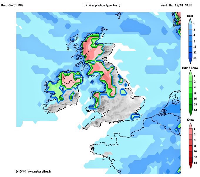
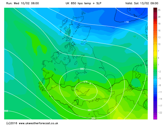
Looking ahead and the following week does see slightly cooler or colder air return with showers, which might be wintry with snow on the hills. Now where’s that Killer Freeze? 🙂

December 2016 Stats

Max 13.3°C (7th)
Min -0.3°C (28th)
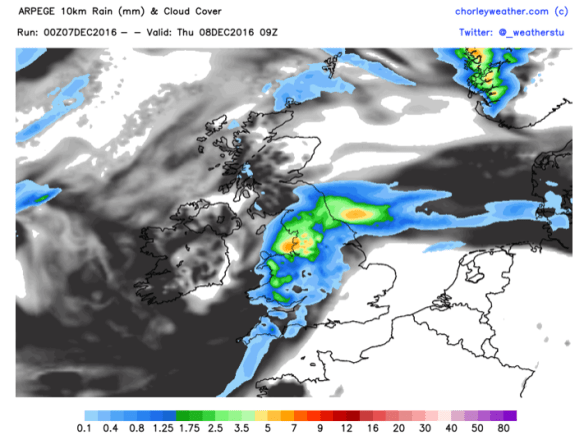
Wettest 16.4mm (8th)
Windiest 49mph (23rd)
Rain 46mm (40% of av.)
Rainy Days 19
Dry Days 12

Thanks for all your support on Twitter and with the blog in 2016. Here’s to an eventful weather year in 2017.

Follow @ChadWeather on Twitter for the latest up to date forecasts. 

Thanks
Jon

Issued: Wednesday 4th January 2017 at 14:30

Images: http://www.metoffice.gov.uk; http://www.netweather.tv

Thursday 15th December 2016 – Sunday 18th December 2016

Hi all,

Not long until Christmas and with the big day in range of our long-term forecast models, we can start to get an idea of what the 25th will be like.

Latest suggestion goes for a mild start with temperatures of 8°C, with rain left over from Christmas Eve, clearing during the morning. More updates on Twitter as we approach the festitives.

xmas-day

A mild start to Christmas Day? Certainly no big freeze as per media stories

Thursday: Mostly cloudy and dull. Some rain at times with some drier spells now and again. Plenty of hill-fog and low-cloud. Something we have been used to lately. Max 10°C

Friday: Another cloudy day with low-cloud and some localised drizzle. Mostly dry in the evening as high pressure builds across the UK. Max 10°C

A mostly dry, cooler and settled weekend ahead but sunshine lacking.

Saturday & Sunday: Plenty of dry weather but also a lot of cloud after a cold misty start in places. Some brightness sneaking through, but with plenty of cloud trapped under the high pressure, don’t be banking on it. Cooler. Max 8°C

wind

Dry start to next week perhaps replaced by wind and rain towards midweek

Looking ahead: High pressure in charge for Monday and Tuesday with dry conditions. Wind and rain spreading from the west midweek. Around average temperatures. No sign of any snow.

Follow @ChadWeather on Twitter for your local weather updates.

Thanks,
Jon

Forecast Issued: 15:35 on Wednesday the 14th of December 2016
Images: http://www.netweather.tv

Thursday 8th December 2016 – Sunday 11th December 2016

Hi all,

After a few weeks of relatively cold weather we are back to our more typical December set-up with mild southwesterly winds. I’m still expecting this winter to be colder-than-average but also not expecting any proper cold until we enter the new year. With a southwesterly airflow, rain will not be too far away over the next 48 hours, although the weekend isn’t looking too bad.

Thursday: Rain to start the day, some heavier bursts. It will tend to become drier as we approach lunchtime and the afternoon will remain mild and cloudy with some hill-fog and localised drizzle. Max 13°C

rain-for-thursday

A wet start to Thursday for all

Friday: Another cloudy day with some bright spells. The mild theme continues and some rain is expected as we head into the evening. Breezy. Max 13°C

A cooler but drier weekend ahead.

Saturday: A cloudy start with some rain knocking around from yesterday. The day should then become dry with bright spells but feeling a little fresher. Max 10°C

Sunday: Not a bad day at all. Sunny spells and feeling cool but with lighter winds it shouldn’t feel too bad. Max 8°C


lows-to-nw

Low pressures next week seem to affect the northwest of the UK the most


A mixed bag as we look ahead. Some cooler days and then some milder shots as we get some southwesterly winds again. Some spells of rain, mostly to the northwest of the UK, so more focus on drier and quieter for us. No sign yet of snow or proper cold. I’ll be tweeting some Christmas Day forecasts soon so watch out for those.

Follow @ChadWeather on Twitter for the very latest.

Thanks,
Jon

Forecast issued 13:45 on Wednesday the 7th of December 2016
Image: http://www.chorleyweather.com/


Thursday 10th November 2016 – Sunday 13th November 2016

Hi all,

So we’re about 10 days into November and some areas have already experienced a ‘winter’ feel with some snow falling on higher ground on Tuesday night and into Wednesday. This is much earlier in the year/season than we are normally accustomed to. As things stand, the ingredients are all there for this coming winter to be a colder-than-average one and possibly, in my opinion, the coldest since 2010/11. Time will tell.

Thursday: An improvement on recent days with bright spells and milder. Some showers expected which could be heavy. Drier into the evening. Max 8°C

Friday: A little cooler again so a fresh feel but better with bright spells and mostly dry conditions. Rain will be trying to push in from the west overnight. Max 7°C

Not a great start to the weekend.

Saturday: Rain heavy at times makes slow progress across the region and slightly milder, showery weather follows. Breezy. Max 10°C

Sunday: Any showers should ease away and an improvement during the day. Bright spells and hopefully most places dry into the afternoon. Max 9°C

A slice of milder air into next week but cooler air should return

Looking ahead and next week looks milder but possibly only for several days then the cooler air returns. Whilst mild, expect some showers or longer spells of rain.

Keep up to date with your local weather forecasts by following @ChadWeather on Twitter.

Thanks,
Jon

Images: http://www.netweather.tv
Forecast Issued: Wednesday 9th November 2016 at 12:20

Thursday 28th April 2016 – Monday 2nd May 2016

Hi all,

Yes it’s nearly May, yes the Bank Holidays are coming, yes it is still cold, so where is the warm weather? The search continues…….

Another Arctic blast of cold air gave some wintry showers this week with plenty of hail, sleet and even snow showers peppering the region but as we head into this forecast, the northerly air supply is set to be cut off as the weather pattern changes.

It will be a cold start on Thursday and as well as a frost in places there is a risk of some localised sleet or snow around, especially above 200M. This will ease away quickly to give a dry slot with bright spells. The cloud will increase into the afternoon and into the evening and overnight there will be some rain with a chance of this turning to sleet and snow on the hills. One to watch and a late bite from the current cold spell. Max 8°C.

The low pressure bringing the rain, sleet and snow will be in charge of the weather on Friday. A cold windy day with further wintry showers which will tend to turn more to rain as the day progresses. Max 8°C.

Low Pressure for Friday

Low pressure in charge this Friday

The good news about the weekend is that temperatures will start to recover and we will get a reasonable day out of it.

A chilly start on Saturday with a ground frost, but hopefully a good day ahead with plenty of sunny spells and mainly dry conditions. We’d be very unlucky to catch a shower but with the ridge of high pressure only weak, they can’t be ruled out. Slightly milder and with the sunshine’s UV levels now at 5 it will feel pleasant. Max 11°C.

All change on Sunday. The Atlantic returns as cloud thickens from the west bringing outbreaks of rain, some heavy. Max 10°C.

Rain arrives into Sunday

It’s looking wet on Sunday with rain from the west

As for Bank Holiday Monday it looks showery, as do the following few days, with temperatures slowly returning to normal. It looks likely that another cold spell won’t arrive, ruling out the chance of any snow in May! That’s my thinking anyway! 🙂

Long-range there is a sign of some warmth, week commencing the 9th of May, especially later on in the week, with temperatures getting close to, or into the 20s. Watch this space.

Finally some warmth

A long way off – but is this our first warm spell?

Follow @ChadWeather on Twitter to catch all the latest weather updates for Manchester and its surrounding boroughs.


Photos/Data: http://www.metoffice.gov.uk, http://www.netweather.tv.

Forecast issued at 13:25 on Wednesday the 27th of April 2016

Thanks for reading,

Jon

Thursday 21st April 2016 – Sunday 24th April 2016

Hi all,

It’s a late blog today because I’ve spent the day enjoying the warmest day of the so far with some strong Spring sunshine. Is it going to continue? Of course not. No more topless sunbathing for me!

Thursday will be a dry day and again warm with plenty of sunny spells. The sunshine will tend to turn hazy later on as high-cloud arrives. Max 15°C.

A change as we go into Friday. It promises to be a cloudier day with some bright spells but the temperature will be much lower as we’ve picked up a north-easterly breeze. Feeling chilly and just maybe some light rain later on. Max 10°C.

colder air again

Another cold Arctic plunge this weekend and the cold lasts into next week

It will turn even colder as we enter the weekend. High pressure builds to our west, low pressure to the east and this allows another cold Arctic feed of air to develop over the country. Similar has occurred recently. It is a set-up we wanted back in late-winter to bring us the snow we all (well me!) wanted.

Both Saturday and Sunday will be cold with a keen north to north-westerly wind. Bright or sunny spells are expected but also some showers, which could, at times, give some hail or sleet or wet-snow to higher ground. A big contrast to earlier in the week. The nights will also become cold with frosts returning. Max 8-9°C.

frosts

The cold nights with frost return this weekend

Looking ahead it looks likely to remain cold with temperatures below average, some showers and a risk of localised frosts. Not what we want to hear as we head towards May!

Follow @ChadWeather on Twitter to catch all the latest weather updates for Manchester and its surrounding boroughs.


Photos/Data: http://www.ukweatherforecast.co.uk; www.tropicaltidbits.com.

Forecast issued at 19:30 on Wednesday the 20th of April 2016

Thanks for reading,

Jon

Thursday 3rd March 2016 – Sunday 6th March 2016

Hi,

Well here we are; welcome to Spring. **ha ha**. After the weather of the past couple of days, you will be right in thinking that it is far from feeling like Spring. Storm Jake blew by today bringing hill-snow and some gusty winds over the tops.

Thursday doesn’t look too bad of a day across the region with bright spells and a scattering of showers, these likely early on. Cold and breezy. Max 6°C. Late-evening and into Friday morning there is a chance of some sleet or snow across the region which could give a covering in places. One to watch on my Twitter feed.

Risk of Snow

Another snow-risk, especially above 200M, Thursday into Friday

Friday itself will remain cold and cloudy with the morning rain, sleet and snow (especially above 200M) slowly fizzling out into the afternoon. There is a possibility of 5-10cm of snow above 250M which could be disruptive to travel. Feeling very cold under the doom and gloom. Max 4°C.

The weekend is set to remain very cold with low pressure to the east dragging northerly winds down across the country but an improvement on Friday. Therefore, we remain under a pool of cold air. So in summary, both days will be cold with a chance of some hail, sleet or snow showers but generally a drier theme overall. Night-times will see some ice, where showers have fallen, and localised frosts. Max 5°C with a biting breeze especially on Saturday.

Northerly Winds

A cold northerly airflow this weekend bringing a bitter breeze

Looking at next week and it looks to remain cold with some wintry showers and overnight patchy frosts. Although it looks a touch milder towards the end of the week, there is no sign of Spring and I can see March panning out to be a cold month overall.

February 2016 Stats

Av. Temp: 4.3°C
Max Temp: 12.6°C (21st)
Min Temp: -2.8°C (16th)
Wettest Day: 31.4mm (8th)
Highest Gust: 51mph (1st)
Rainfall: 119.2mm
Rainy Days: 21

Remember to follow @ChadWeather on Twitter to catch all the latest weather updates for Manchester and its surrounding boroughs.

Thanks for reading and feel free to share.

Jon

Photos/Data: http://www.ukweatherforecast.co.uk and http://www.netweather.tv

Forecast issued at 2:20pm on Wednesday 2nd of March 2016.

Thursday 25th February 2016 – Sunday 28th February 2016

Hi all,

OK, I’m not getting the snow I’m hanging desperately on to this winter for, but at least it feels more like winter now, with frosty mornings and some wintry sunshine.

It looks like the current cold spell is set to continue into March with just the odd milder day thrown in, so this keeps the door open for a snow-risk.

Thursday will start with a widespread frost and some rural spots may have had their coldest night of the winter with -6°C possible. There is also a risk of some patchy dense freezing fog, so something to be aware of on the roads in the morning. Once this clears we’ll have a day of sunny spells and it will be dry. Cold though. Max 4°C.

NEW Thu AM

A freezing start to Thursday – coldest temperatures of the winter possible

Another frosty morning possible on Friday but not as severe as cloud is expected to push in from the west. Chance of some wintry showers later in the day from the south-west but the focus remains on a mainly dry picture but with more cloud than yesterday. Max 5°C.

Finally a weekend without a washout day and non-stop rain. I promise.

Saturday and Sunday similar actually, with a lot of dry weather around as high pressure builds over the UK. It will also introduce a bitter easterly breeze at times. OK, we might see the odd sleet or snow flurry, or spot of rain but overall it will be dry with sunny spells and some frost to start the mornings. Max 5-6°C.

high pressure

Settled Conditions – A ridge of high pressure over the UK at the weekend

Looking ahead and as we enter March, meteorologically-speaking the start of Spring, it remains cold at first, but there are some signs that the Atlantic will try to come back to bring slightly milder conditions and some rain. If so, it could be preceded by some snow. One to watch next week.

Remember to follow @ChadWeather on Twitter to catch all the latest weather updates for Manchester and its surrounding boroughs.

Thanks for reading and feel free to share.

Jon

Photos/Data: http://www.netweather.tv

Forecast issued at 2:00pm on Wednesday 24th of February 2016.

Thursday 18th February 2016 – Sunday 21st February 2016

Hi all,

Welcome to another weather outlook for across our region.

Finally we managed some dry weather. Last Friday (12th) to this Tuesday evening we managed almost 5 dry days. Quite an achievement after 19 days of consecutive registered rainfall, but as I write this, we are again plagued by persistent rainfall.

The weather is heading back into a topsy-turvy flow with the Jet stream back in charge as we head towards the weekend and then introducing colder air when it dips away to the south next week.

After we experienced a miserable, wet and cold Wednesday, we will see a much improved day on Thursday. However, with clear skies to start the day we must be aware of ice after all of yesterday’s rain. During the day, plenty of sunny spells with the risk of a light afternoon shower but well-scattered. Max 6°C.

A chilly start to Friday with another localised frost but cloud will soon thicken, and rain, some heavy is expected to arrive as the day progresses giving us a wet afternoon. Temperatures will lift as winds turn south-westerly introducing milder air. Max 9°C.

milder air returns

Milder air returns from Friday and into the weekend


We head into the weekend with grim prospects.

Any early brightness on Saturday doesn’t last long and rain will move in from the Atlantic. It will also be mild and breezy at times. Max 10°C. 

I wish I could say something better about Sunday but I can’t. More rain is expected and windy for a time too. The exact timing of the rain over both weekend days is not nailed on but it’s not a weekend that will be remembered for decent weather. Later in the day, the rain is likely to move away towards the south-east and be replaced by much colder weather and wintry showers, with snow on the hills above 250M. Again, some uncertainty on timing and it might not even happen until we enter Monday. Max 12°C.

Snow Showers

Colder later on Sunday and into Monday; could mean hail, sleet & snow showers to follow


A lot of rain fell today (Wednesday the 17th) and with more rain between Friday and Sunday; there could be a concern again for local football matches to have waterlogged pitches.

Total Rainfall

Another inch of rain expected between now and Monday


Looking ahead and next week will be colder than the mild weekend with wintry showers at times and some chilly nights with a risk of localised ice and frost.
Remember to follow @ChadWeather on Twitter to catch all the latest weather updates for Manchester and its surrounding boroughs.

Thanks for reading,

Jon

Photos/Data: http://www.ukweatherforecast.co.uk; http://www.netweather.tv and http://www.weatheronline.co.uk

Forecast issued at 15:00 on Wednesday 17th of February 2016


Thursday 11th February 2016 – Sunday 14th February 2016

Hello again,

Another week has gone by and more rain has fallen across the region. In fact, Monday (8th Feb) was the 4th wettest day since my records began here in August 2012, with 31.4mm of rain recorded. This all came from Storm Imogen which brought almost 100mph gusts to the south coast. Although we didn’t feel much impact from the winds [41mph recorded Monday night] it never stopped raining.

All this wet weather led BBC Radio Manchester to get in touch, as they had a feature on the show this morning (10th) regarding the non-stop wet weather we have been having. I was unable to attend as I was on the school run but it did give me the opportunity to dig out some statistics for them.

  • We are today (10th) likely to have our first dry day for 17 days!
  • Since November the 1st 2015 we have had 635mm (25 inches) of rain and in that time 90% of the days recorded rainfall. That’s 6mm a day on average.
  • We have only had 10 dry days since the end of October 2015.

The Jet stream is now slightly further south so we are experiencing some colder air and some welcome sunny spells. Not only does it look like today will be dry, Thursday and Friday could follow suit.

Jet stream

The Jet stream has dipped south into the back end of this week

A cold start to Thursday with local fog and frost, so you could be deicing before work. A mainly dry dry to follow with sunny spells and a low risk of a fleeting wintry shower. Max 6°C.

Similar on Friday, cold start, some localised frost but more cloud is expected later in the day. Beforehand, plenty of bright spells and again we should escape with a dry day. A cold easterly breeze arriving. Max 5°C.

Now into the weekend, Saturday, it gets a little tricky.

Saturday will be cold with a mainly cloudy picture across the region. There is a risk of rain coming in from the south-west, the track of this and how far north it gets is still uncertain. It could turn to snow in places as the milder air meets the cold air. My feeling is that it will stay further south but one to watch for updates via Twitter and I should know more by Thursday evening. Bitter easterly breeze. Max 4°C.

rain or snow

A risk of rain turing to snow on Saturday – where, is still uncertain

cold v mild

Snow could occur where the mild air meets the cold air

The low pressure and its mix of rain or snow moves away south into Sunday allowing the winds to switch from an easterly to an Arctic northerly bringing the risk of scattered hail, sleet or snow showers but sunny spells as well. A low windchill. Max 4°C.

Both nights over the weekend will be cold with a risk of ice and frost.

windchill

Sub-zero windchill of -5 by the end of Sunday

frosty early next week

Settled, drier but frosty as we head into next week

Looking ahead and early next week sees some settled weather with sunny spells by day and cold frosty nights. Later in the week it looks likely that the winds will return to bring the Jet stream back over us and with it some wetter milder weather but there is some question mark over the timing of this. For now though, the good news is, no significant rainfall or another named-storm on the cards.

will the jet come back

But when will that Jet stream and the wetter/milder weather return?

Remember to follow @ChadWeather on Twitter to catch all the latest weather updates for Manchester and its surrounding boroughs.

Thanks for reading,

Jon

Photos/Data: http://www.ukweatherforecast.co.uk; http://www.netweather.tv and http://www.theweatheroutlook.com

Forecast issued at 14:15 on Wednesday 10th of February 2016