Thursday 4th January 2018 – Sunday 7th January 2018

Hi all,

Happy New Year and all the best for 2018!

I hinted that we would end 2017 with a named-storm and in rolled Storm Dylan to be followed by Storm Eleanor yesterday. The Jet Stream has been in charge of our weather in recent days but it will split this weekend and high pressure will build. A northeasterly flow will develop and we will enter a much colder but drier spell of weather.

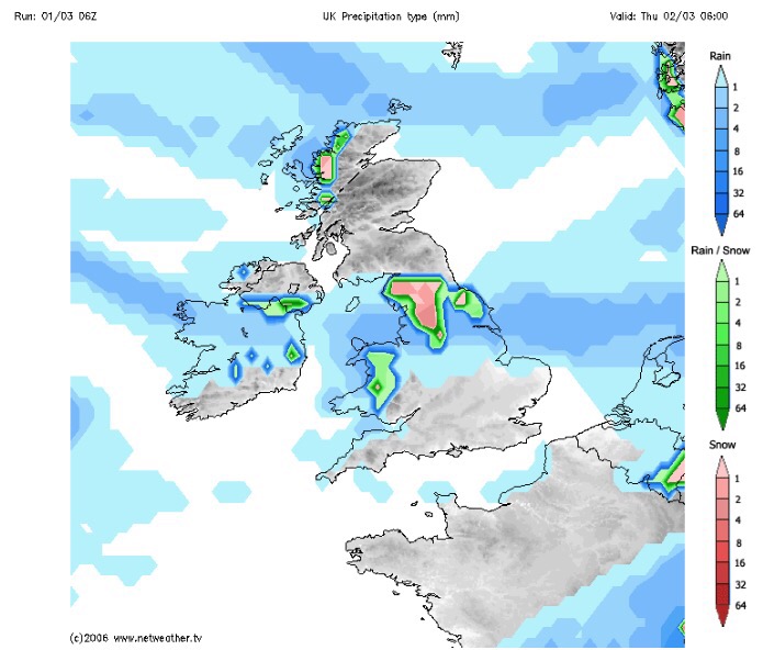
Thursday: Cloudy with rain for the morning turning showery into the afternoon as the rain band pushes slowly north. We are still in the mild air so temperatures just above average. Max 8°C

Friday: Cloudy with some showers. There will be a little bit of brightness too and as the day progresses, it will get colder. Max 4°C

Weekend: Dry and colder with a biting wind-chill.

Saturday: Cold and mostly dry with some bright spells and the chance of a wintry shower blown in on a freezing northeasterly wind. Widespread frost overnight. Max 4°C

Sunday: Dry with sunny spells after a frosty start. Less breezy, so a pleasant day to get out and about if you’re wrapped up well. Frost returning at night and if winds fall light enough perhaps some fog. Max 4°C

Outlook: High pressure will face a battle with fronts trying to push in from the Atlantic. It will remain cold with plenty of dry weather. Cloud will increase from the west with a risk of rain, preceded by snow, possibly pushing the high pressure away by midweek. If this happens it would turn milder but there’s a reasonable chance that we get ‘locked in’ to the cold for while. Look out for updates on Twitter.

Follow @ChadWeather on Twitter for your weather forecasts.

Thanks,

Jon

Forecast issued at 3:45pm on Wednesday January 3rd 2018

Thursday 21st December 2017 – Monday 25th December 2017

Hi all,

So far December has been a month of variations and, as of the 19th, we are colder and drier than average. With the recent snow and bitterly cold temperatures some of us might be hoping for a White Christmas. It’s not going to happen this year folks.

Thursday: Cloudy with spells of light rain or drizzle with hill-fog for most of the day. Another drab day but most of the rain should ease away into the afternoon. Mild. Max 10°C

Friday: Mostly cloudy, patches of mist/fog and remaining mild. There is a chance of some brightness (forgotten what that is!) developing, especially in eastern parts, during the day. Max 10°C

Saturday: Perhaps, don’t hold your breath, a bright start but cloud increasing and the breeze picking it. Some rain likely later in the day. The wind remains from the southwest so above average temperatures again. Max 10°C

Christmas Eve: Windy with cloudy skies. Rain likely as the day progresses and it will be heavy on western-facing hills and in the northwest. Very mild. Max 11°C

Christmas Day: A day of change albeit slowly. A damp day, bah humbug!, with some rain moving south. It will remain mostly cloudy and mild but a little cooler than lately. Later into the evening and overnight colder air will arrive from the northwest. To warrant a White Christmas we need a single snowflake falling before midnight and this is highly unlikely. Max 9°C

Outlook: Colder at times but with spells of rain and possible gales coming in from the west. Don’t rule out another named-storm before we see out 2017.

Finally, I wish you all a very Merry Christmas and all the best for 2018!

Thanks,
Jon

Forecast issued at 11:15am on Wednesday 20th of December 2017


Thursday 14th December 2017 – Sunday 17th December 2017

Hi all,

Sorry it’s a day late. Well what a busy few days that was, and nice to see some snowfall in the early stages of winter. It was a shame (a lot were relieved) that Sunday’s snowfall, which would have been 6 inches or more, ended up further south. Maybe next time…..

Thursday afternoon:  Some bright spells but also some wintry showers. Feeling bitter in the fresh westerly wind. During the evening and overnight a band of rain will move south which could be wintry on higher ground. Max 5°C

Friday: Breezy with Arctic air returning so feeling very cold after a frosty and icy start. Some sunny spells and wintry showers possible, especially to the northeast, so a chance of some hail or snow falling again. Max 4°C

Weekend: Saturday’s the better day.

Saturday:  Still cold with a sunny start but clouding over later in the day. I’m hopeful it does remain dry for most. Max 4°C

Sunday: A change on the way, rain arrives from the southwest and with it much milder air so temperatures lifting. Max 8°C

Outlook: Staying milder than recently with temperatures close to double-figures and with it plenty of cloud which brings a chance of hill-fog and some drizzle or light rain. Look out on Twitter for forecasts for Christmas Day. Early thoughts are, no chance of a White Christmas.

Follow @ChadWeather on Twitter for the latest forecasts.

Thanks,

Jon

Forecast Issued at 12:50pm on Thursday the 14th of December 2017

Thursday 30th November 2017 – Sunday 3rd December 2017

Hi all,

We saw our first snowfall of the winter last week…. well actually no, it was our first snow-cover of autumn. Yes, it is still autumn, despite the cold and it’s been a wet (only 4 dry days) end to November but winter will finally be here, meteorologically-speaking, on Friday!

On Saturday, it’s time for the annual Saddleworth Santa Dash and Switch On! But will the weather be kind?

Thursday:  Dry with plenty of sunshine but still very cold after a severe-frost to start where rurally temperatures will have been close to -7°C. During the day the breeze will bring a sub-zero windchill. A frost will return overnight. Max 3°C

Friday:  Some sunny spells at times, especially early on. A frosty start again but with more cloud-cover not as cold as Thursday morning. Less in the way of clear skies overnight means any frost will be patchy. Slightly milder. Max 4°C

Weekend: Slightly milder with cloudy skies and some patchy rain. No frosts.

Saturday:  Cloudy with some patchy rain, not everywhere seeing some, turning less cold. Max 6°C

Sunday:  A similar picture with limited brightness and plenty of cloud. Not wet everywhere just some patches of drizzle especially on higher ground. Temperatures around average.  Max 9°C

Outlook: Mild and cloudy on Monday and early Tuesday, then colder air with some brighter skies will return. For now, no snow on the horizon which will disappoint all those Daily Express believers.

Follow @ChadWeather on Twitter for the latest forecasts.

Thanks,
Jon

Forecast issued on Wednesday the 29th of November 2017 at 3:40pm.

Thursday 23rd of November 2017 – Sunday 26th November 2017

Hi all,

Well hello weather, we welcomed back our typical Autumn this week, with an inch of rain falling in the first few days. We’ve also had a bit more snow-talk on the grapevine and this time there is some truth in the rumours. No no, don’t get your sledges out just yet, just be ready for a cold weekend with a risk of wintry showers.

Thursday: A mild start with some bright spells but showers will start to appear as the day progresses. Remaining windy and slowly becoming colder. Max 9°C

Friday: A better day and hopefully we will escape with a dry one with sunny spells. It will feel colder again with temperatures really struggling, leading to a slight frost overnight. Max 6°C

Weekend: Cold and breezy with wintry showers and some night-time frosts.

Wintry Showers

Wintry showers, some falling as snow especially on Saturday

Saturday: A bitter day with some bright spells and wintry showers which will could fall as hail or sleet. Some snow showers are possible, in any heavier bursts and certainly more likely on higher ground. Max 5°C

Sunday: More in the way of sunshine with a few wintry showers left over, but there shouldn’t be as many as Saturday. Still cold, especially with the freshening breeze ahead of rain due late-evening and overnight. Max 6°C

Outlook: A touch milder with some rain but then it seems the colder air returns and with it the risk of wintry showers and overnight frosts.

Follow @ChadWeather on Twitter for the latest forecasts.

Thanks,
Jon

Forecast Issued on Wednesday 22nd of November 2017 at 11:35am.
Image: http://wxcharts.eu/

Thursday 16th November 2017 – Sunday 19th November 2017

Hi all,

The chilly feel has continued in November and although we’ve had a few days here and there with milder, damp weather, there’s not been a continous deluge of rain. Currently we’ve only had 29mm (102mm is the monthly average). Is the colder weather a sign of things to come? With La Nina underway there is an increased chance of a colder start to winter. See Liam Dutton’s video for more, La Nina.

Not only is Liam’s video informative, it is also keeping it real.

The latest Daily Express headline is more of their clickbait tactics, with over-the-top headlines and untrue statements.

BS

Moving on……

November Stats so far:

Nov 2017

Thursday: A band of patchy rain will move southeastwards during the morning and early afternoon to be replaced by sunny skies and drier conditions but with it, colder air. Max 10°C

Friday: High pressure out west so a settled day with sunny spells and a cold northwesterly breeze. Just the odd shower possible. Max 9°C

Saturday: A breezy day with perhaps a spell of cloud and light rain for a time in the morning. Bright spells developing later with a few showers and still cold. Max 8°C

Sunday: A bright, cold start, perhaps frosty, then cloud increasing with some milder air coming in from the west bringing with it rain as we get into the late-afternoon and evening. Max 8°C

Outlook: Dull and damp on Monday but hopefully drier and brighter thereafter, as high pressure builds. This increases the risk of fog and frost. No snow on the horizon but it will remain cold with temperatures struggling to double-figures.

Follow @ChadWeather on Twitter to keep up to date with the forecasts.

Thanks,
Jon

Forecast Issued: Wednesday 15th November 2017 at 12:30pm

Thursday 9th of November 2017 – Sunday 12th of November 2017

Hi all,

Yep the media are still at it. Anyone got their sledges out? Nope. The weather does have a chill about it, already, but it is anyone’s guess what winter will bring.

Thursday: A cloudy start with milder air back again across the region. Some rain likely in the morning but patchy in nature. This will ease away and some bright spells will break out and lead to a drier afternoon. Max 11°C

Friday: A cloudy and breezy day with bright spells and some showers especially so in the morning. A band of rain moving through overnight. Max 10°C

Weekend: Cold, especially in the wind.

Saturday: A northwesterly airflow will take hold over the UK this weekend and it will feel cold. We’ll see some brightness on Saturday, but also some showers blown in on that keen breeze. Max 9°C

Sunday: A drier day is expected with sunny spells and a few lingering showers. Remaining cold with a frost likely overnight as skies clear. Max 9°C

Outlook: Slowly becoming less cold and cloudier after a decent Monday. Temperatures close or just below average. No sign of any snowfall or any named-storm on the horizon. We could become stuck under a cloudy-high, which means little sunshine but very settled conditions.

Follow @ChadWeather on Twitter for the latest localised forecasts.

You can also view hourly weather stats tweets at @OldhamWxStats and 1-minute data updates from my personal weather station on Wunderground.

Thanks,
Jon

Forecast Issued at 4:30pm on Wednesday the 8th of November
Image: wxcharts

Thursday 2nd November 2017 – Sunday 5th November 2017

Hi all,

Winter is still on the horizon but after a frost this week and a chilly outlook, it will be here sooner, rather than later. A lot of media stories this week; “Coldest Winter in 11 years” etc. etc. Just ignore them. It’s complete guesswork. No-one knows what this winter will bring. Got to love their annual BS.

Thursday: A mostly cloudy start with a risk of some patchy rain moving through but it will soon clear to leave a decent day with plenty of sunny spells and dry. Good news for those off to the Big Bang at Oldham Edge in the evening. Max 12°C

Friday: Cloudy with some light rain or drizzle dotted about especially so into the evening. Some bright spells can’t be ruled out in the odd sheltered location during the morning. Rain overnight. Max 11°C

Colder than average this weekend

Colder than average this weekend

Saturday: Any early morning rain clearing then colder with bright spells and showers which could fall as hail. Feeling cold in a gusty northwesterly wind. Max 9°C

Sunday: Bright spells after a chilly start. Risk of some showers on the keen breeze but these should ease as the day progresses. Remaining cold with temperatures just below average and a frost likely overnight. Max 9°C

Outlook for the rest of next week: High pressure builds from the west, so plenty of dry, settled weather. Not bad during daylight hours with light winds and sunny spells. Some patchy frost and fog overnight. Just one exception is Tuesday where we could have a narrowing band of rain and wind sweep through quickly.

October 2017

Max 19.4°C (16th)
Min 0.9°C (30th)
Av. 11.6°C
Wettest 21.4mm
Windiest 44mph
Rain 105.6mm
Rainy Days 20
Dry Days 11

Follow @ChadWeather on Twitter for the latest forecast for your area.

Cheers
Jon

Images: www.wxcharts.eu
Forecast Issued at 8pm on Wednesday the 1st of November 2017

Thursday 2nd March 2017 – Sunday 5th March 2017

Hi all,

Winter has gone, meteorologically-speaking of course, but we all know we tend to see snow in March at some point, so don’t unpack the garden furniture just yet. Speaking of snow, there could be some overnight on Wednesday with up to 7cm possible above 300M. See Twitter for updates.

Rain likely to turn to snow Wednesday night.


Thursday: Cloudy with rain, sleet and snow during the morning. Drier into the afternoon with some brightness. Breezy too making it feel cold. Some more rain late-evening. Max 7°C

Friday: Some drier, bright spells during the day, but later cloud will thicken with a risk of more rain coming up from the southwest. A cold breeze. Max 7°C

Saturday: A messy picture on Saturday as low pressure from the south swings up another weather front which could stall over the region bringing a wet day with rain at times. There is some uncertainty how far north it gets so watch for updates on my Twitter, @ChadWeather. Max 6°C

Sunday: I’m hoping a little ridge of high pressure builds for Sunday so we have a drier day with some brightness. Temperatures remaining similar values.  Max 7°C

Looking ahead: Temperatures around average, bright spells but also a lot of cloud which will limit the frost-risk. Some showers.

February 2017 Stats

Max 13.1°C (20th)
Min -0.1°C (28th)
Wettest 18.8mm (23rd)
Windiest 49mph (23rd)
Rain 101.8mm (above average)
Rainy Days 23
Dry Days 5
Snow Falling Days 4
Snow Lying Days 1

Thanks,
Jon

Image: http://www.netweather.tv
Forecast Issued: Wednesday 1st of March at 2pm

Thursday 23rd February 2017 – Sunday 26th February 2017

Hi all,

The final blog of winter 16/17 and what a disappointment it has been, when it comes to proper cold and snow. However, even though March is classed as Spring, I expect it will throw some cold spells at us with some snow before we feel the Spring warmth that we’ve all been waiting for.

Before all that, Storm Doris, and with her, an AMBER weather warning which is not that common, even during winter. The storm is yet to form. It will be developing quickly as it approaches and crosses the UK. At the time of publishing these are the warnings: Yellow and Amber Weather Warnings.

warning-areas

The warning areas – we just sit in the AMBER area


Thursday: Be aware that there could be disruptive weather with some structural damage. The day will dawn quite ‘calm’ with what’s to come, with some rain moving in from the west. The rain will become heavy and from mid-morning the winds will increase quickly. Widely we can expect gusts to 50mph. There will be a spell of windier conditions, where we could locally see 60mph gusts and perhaps up to 80mph in exposed places. These gusts are strong enough to damage property and uproot trees. The strongest gusts are expected to be between 11am-3pm but times may vary so watch out for updates on Twitter. As the storm moves through, the winds will turn northwesterly and introduce colder air, so don’t be surprised to see some sleet or snow from mid-afternoon onwards. This is more likely to fall on higher ground (above 300M) and on the Pennines where there will be a few inches. Although it will become less windy into the evening, we can still expect gusts to 40mph. Overnight, further wintry showers with possible hail and feeling colder. Max 9°C which will be during the morning.


snow

Storm Doris will bring a lot of snow to Southern Scotland and Northern England


Friday: A much quieter day. Once you have found your garden furniture, we can expect some showers early on but then drying up and remaining mostly cloudy with less wind. Further rain overnight. Max 6°C

Saturday: Early rain will move through but some blustery showers will follow on behind. Another spell of windy weather with gusts to 35-40mph. Milder. Max 10°C

Sunday: It should be a fine start with some bright spells. Cloud thickening later on as another low pressure comes in with some rain and breezy conditions. Max 9°C

Looking ahead: Next week will start cooler with some showers. The rest of the week will see it slowly turn milder as the weather settles down. Drier conditions favourable but a lot of cloud once more. Let’s hope March sees a decent snowfall before we close the door on Winter 16/17.

Cheers,
Jon

Images: http://wxcharts.eu; http://www.netweather.tv; http://www.metoffice.gov.uk.

Forecast Issued: Wednesday the 22nd of February at 12:00pm