
Hi all,
The final third of winter is here and this starts after the coldest January for a decade. We haven’t seen any bitter cold, but that’s about to change. No Beast from the East on the way but a biting wind-chill and snow arriving from the east.
Thursday: Rain, with some sleet and wet-snow on the Pennines, will push northeast during the early morning. Bright spells and a few showers will follow and temperatures lift to become quite mild. Max 9°C
Friday: Further showers or longer spells of rain with it turning a little cooler later in the day. Change is waiting in the ‘winds’. Max 7°C
Weekend: Turning much colder with some snow.
Saturday: Winds swing to the northeast during the day and with it some wintry showers pushing in, turning more so to snow overnight. Breezy. Max 4°C
Sunday: Raw biting easterly winds with snow showers coming inland from the North Sea. These will be most frequent in the east with snow-cover for many. Sub-zero wind-chill making it feel like -5°C with 25-30mph gusts. Ice and further snow showers overnight. Max 1°C
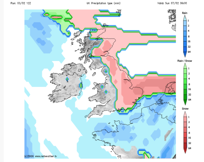
Outlook: Very cold conditions to continue most of the week with further snow showers on Monday then it looks generally cloudy but drier. Hints at milder weather with rain, preceded by snow, coming in from the Atlantic towards the weekend but this is not set in stone.
January 2021 Stats
Max 9.7°C (20th)
Min -3.7°C (7th)
Av. 2.6°C
Av. Dew Pt 1.3°C
Wettest 41.4mm (20th)
Av. Humidity 91%
Av. Barometer 1011.6 hPa
Max Gust 33mph (30th)
Av. Wind Direction WSW
Rain 176mm
Rain Registered Days 24
Dry Days 7
Air Frosts 14
Snow Falling Days 10
Follow @ChadWeather on Twitter for the latest weather forecasts.
Thanks,
Jon
Forecast Issued: Wednesday the 3rd of February 2021 at 8pm.
Image: http://www.netweather.tv
