Thursday 1st November 2018 – Sunday 4th November 2018

Hi all,

Brrrrr! It’s been a chilly week, with local frosts, a cold northerly wind and even some snow flurries! More like Winter than Autumn. After our dry summer, water levels are still low and October was another dry month, with around 50% of the average rainfall.

Thursday: Mostly cloudy with some rain to start, followed by brighter skies and a few showers. Max 9°C

Friday: A cold start with a ground-frost. A decent day ahead and if you’re at a Bonfire this evening then there will be good conditions. During the day, sunny spells and mostly dry with winds increasing later in the day with rain overnight. Max 10°C

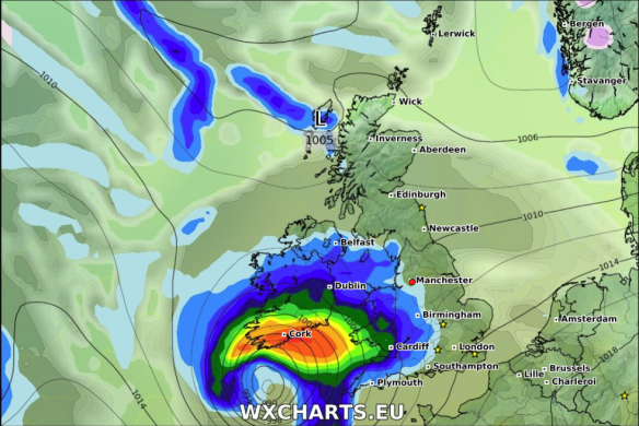
Weekend: We throw the remnants of ex-Hurricane Oscar into the mix on Saturday

Oscar

Ex-Hurricane Oscar will pass to the NW of the UK on Saturday

Saturday: Windy with 35-40mph gusts, a little higher in exposed places. A band of rain quickly clearing to showers. Much milder with a southwesterly airflow. Max 13°C

Sunday: A bright day and it should stay dry during daylight hours. Another developing area of low pressure is likely to come in from the west, so windy with rain or showers into the evening or overnight. Max 12°C

Outlook: Temperatures around or above average. Not a bad week ahead. Bright spells and just a few showers. No sign of a winter-like spell returning.

October 2018 Stats (up to and inc. 30th)

Max 21.9°C (10th)
Min 0.6°C (27th)
Av. 10.0°C (colder than average)
Wettest 10mm (13th)
Windiest 37mph
Rain 47mm (47% of average)
Rain Days 19
Dry Days 11

Follow @ChadWeather on Twitter for the latest weather forecasts.

Thanks,
Jon

Forecast Issued: Wednesday the 31st of October 2018 at 1:25pm
Image:
 http://wxcharts.eu
 

Thursday 10th May 2018 – Sunday 13th May 2018

Hi all,

So that’s two very warm summer-like spells of weather so far this year. Can’t grumble and no they weren’t heatwaves. So when’s the next one please? I’m getting itchy feet :).

Thursday: Any early cloud from last night’s rain soon clearing and a reasonable day with plenty of sunny spells. Feeling warm in the sunshine. Max 14°C

Friday: Sunny spells for the morning but turning breezy and cloudier into the afternoon. Rain arriving into late-evening and overnight. Max 15°C

Weekend: Much cooler than last week but not too shabby.

Saturday: Sunny spells and temperatures nothing to cheer about, but feeling pleasant in the sunshine again with light winds. A risk of some showers from the south-west towards evening. Max 14°C

Sunday: Bright spells and it should be dry as we keep a band of rain away to our east and showers away to our south-west. Just a chance of developing a shower over the Pennines or hills. Max 14°C

Remember at this time of year the sun is as strong as early-August, UV levels are at 6, so apply sun-cream if you’re planning to be out in it for a while, otherwise you will burn regardless of what the temperature is.

Outlook: Hopefully high pressure will build to the south-west of the UK, so expect it to turn warmer, not hot, with decent spells of sunshine. Temperatures in the upper teens. Variable amounts of cloud at times, a slight breeze and mostly dry.


Follow @ChadWeather on Twitter for the very latest.

Thanks,
Jon

Forecast issued at 2pm on Wednesday the 9th of May 2018

Thursday 26th April 2018 – Sunday 29th April 2018

Hi all,

This time last week we were entering a few days of summer-like weather and oh how good it felt, but it already feels like an age ago. Yep, we are back to our standard Spring.

Thursday: Sunshine and showers, some heavy with hail and thunder possible but fewer showers than yesterday. Max 12°C

Friday

Some uncertainty about the track of this low on Friday but potential for heavy rain 

Friday: Bright spells to start but soon thicker cloud will spread up from the southwest with rain, some heavy too, especially in southern areas. Feeling cool. Max 10°C

Weekend: We remain on the northern side of the Jet Stream so cool and showery with chilly nights.

Saturday: Friday’s low will have moved away into the North Sea allowing a cool northerly or northeasterly airflow to bring showers down across the region. Chilly. Max 11°C

Sunday: Bright spells and a few well-scattered showers. Catch one and it will be heavy. A cool breeze. Max 11°C

Outlook: We enter May with unsettled and cool weather in charge. No sign of any sunny and warm conditions returning.

Follow @ChadWeather on Twitter for the latest forecasts.

Forecast issued on Wednesday the 25th of April 2018 at 16:20.
Image: http://wxcharts.eu

Thanks,
Jon