Thursday 22nd December 2016 – Boxing Day 2016

Hi all,

First I would like to wish you all a very Merry Christmas and hope you all enjoy the festivities despite this forecast.

Deep snow? Nah, we have wind and rain to look forward to, and possibly two named storms. After the recent stagnant weather this is a noticeable change especially after a quiet December with rainfall only at 40% of the monthly average.

Thursday: A chilly start with some frost and localised icy patches. Sunny spells and breezy with a risk of a shower or two. These could fall as hail. Feeling cold. Max 7°C

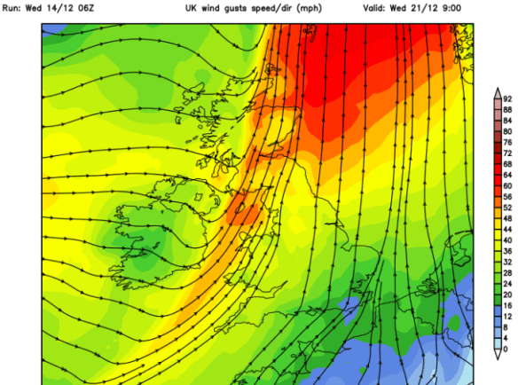
Storm Barbara approaching the U.K.

Friday: A little milder but really not noticeable as Storm Barbara arrives bringing heavy rain after a dry start. It will be windy with gusts of 50mph likely. Weather warning in place. Exposed places could see 60mph. Watch my tweets for updates. Max 10°C

Christmas Eve: Remaining windy with some blustery showers and feeling cold. More rain and wind overnight. Max 8°C

A very mild Christmas Day but colder overnight into Boxing Day

Christmas Day: Early rain, mild and very strong winds. Weather warning in place. There is still some uncertainity about this ‘storm’ and its track. If it develops to be strong enough to be named it will be Storm Conor but at the moment it doesn’t look like it will develop into a system like the one on Friday. During the day we could see gusts to 50mph once again. Later on the rain clears to some scattered blustery showers. Some colder air feeds in overnight, so we could see hail and even some sleet or wet snow to the hills. Max 11°C

The weather calms down as high pressure builds after Boxing Day

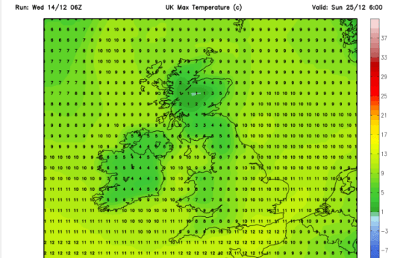
Boxing Day and the following few days: Still windy initially then much improved as high pressure builds and the weather eventually ‘relaxes’. Plenty of drier conditions with a risk of some frosts overnight. Chilly at first but maybe becoming slowly milder. Max 7°C

Keep up to date with the latest weather forecast by following @Chadweather on Twitter.

Thanks,
Jon


Forecast issued: 11:00am on Wednesday the 21st of December 2016

Images: http://www.wxcharts.eu; http://www.ukweatherforecast.co.uk; http://www.wetterzentrale.de

Thursday 15th December 2016 – Sunday 18th December 2016

Hi all,

Not long until Christmas and with the big day in range of our long-term forecast models, we can start to get an idea of what the 25th will be like.

Latest suggestion goes for a mild start with temperatures of 8°C, with rain left over from Christmas Eve, clearing during the morning. More updates on Twitter as we approach the festitives.

xmas-day

A mild start to Christmas Day? Certainly no big freeze as per media stories

Thursday: Mostly cloudy and dull. Some rain at times with some drier spells now and again. Plenty of hill-fog and low-cloud. Something we have been used to lately. Max 10°C

Friday: Another cloudy day with low-cloud and some localised drizzle. Mostly dry in the evening as high pressure builds across the UK. Max 10°C

A mostly dry, cooler and settled weekend ahead but sunshine lacking.

Saturday & Sunday: Plenty of dry weather but also a lot of cloud after a cold misty start in places. Some brightness sneaking through, but with plenty of cloud trapped under the high pressure, don’t be banking on it. Cooler. Max 8°C

wind

Dry start to next week perhaps replaced by wind and rain towards midweek

Looking ahead: High pressure in charge for Monday and Tuesday with dry conditions. Wind and rain spreading from the west midweek. Around average temperatures. No sign of any snow.

Follow @ChadWeather on Twitter for your local weather updates.

Thanks,
Jon

Forecast Issued: 15:35 on Wednesday the 14th of December 2016
Images: http://www.netweather.tv

Thursday 17th November 2016 – Sunday 20th November 2016

Hi all,

A bit of a late posting today, but I’m finally here with the usual weekly outlook on what our weather’s going to throw at us. It’s certainly not going to disappoint this week.

Thursday: Cold and windy. Showers of rain and possibly hail and thunder. Some sleet for the hills. There is a chance of more prolonged rain during the morning. 6°C

**There is a possibility that wintry showers will merge together to bring a spell of sleet or snow overnight on Thursday, especially above 200M. One to keep an eye on via my tweets**

Possibilities of some localised sleet and snow overnight Thursday and into Friday morning. Above 200M most at risk.

Friday: Possibly a wintry start as mentioned, then feeling quite bitter with a stiff northwesterly wind and some wintry showers. Sunny spells during the day mixed in with those showers. Showers dying away overnight leading to a frost. 5°C

Heavy rain arrives on Sunday, preceded by Pennine-snow?

Saturday: Frosty start, then a typical pleasant, autumnal day. Sunny spells, just the odd wintry shower but with lighter winds it won’t feel as cold as previous days. 6°C

Sunday: Another cold start with a touch of frost. Cloud soon thickening and the wind increasing as heavy rain, possibly preceded by hill-snow for a time, moves in from the south-west. There is a good deal of uncertainty about how strong the winds could be and how heavy the rain will be so keep your eyes on my tweets. A cold raw feeling day. 7°C

Looking ahead and it’s set to stay cold with unsettled conditions close by. 

Keep up to date with your local weather by following @ChadWeather on Twitter.

Cheers,

Jon

Images: http://www.netweather.tv

Forecast issued Wednesday 16th November at 18:30. 


Thursday 10th November 2016 – Sunday 13th November 2016

Hi all,

So we’re about 10 days into November and some areas have already experienced a ‘winter’ feel with some snow falling on higher ground on Tuesday night and into Wednesday. This is much earlier in the year/season than we are normally accustomed to. As things stand, the ingredients are all there for this coming winter to be a colder-than-average one and possibly, in my opinion, the coldest since 2010/11. Time will tell.

Thursday: An improvement on recent days with bright spells and milder. Some showers expected which could be heavy. Drier into the evening. Max 8°C

Friday: A little cooler again so a fresh feel but better with bright spells and mostly dry conditions. Rain will be trying to push in from the west overnight. Max 7°C

Not a great start to the weekend.

Saturday: Rain heavy at times makes slow progress across the region and slightly milder, showery weather follows. Breezy. Max 10°C

Sunday: Any showers should ease away and an improvement during the day. Bright spells and hopefully most places dry into the afternoon. Max 9°C

A slice of milder air into next week but cooler air should return

Looking ahead and next week looks milder but possibly only for several days then the cooler air returns. Whilst mild, expect some showers or longer spells of rain.

Keep up to date with your local weather forecasts by following @ChadWeather on Twitter.

Thanks,
Jon

Images: http://www.netweather.tv
Forecast Issued: Wednesday 9th November 2016 at 12:20

Thursday 13th October 2016 -Sunday 16th October 2016

Hi all,

We’ve been under the influence of a huge area of high pressure based over Scandinavia for a good while now but finally things are about to change. If only we had had this set-up in winter.

Thursday: A cool easterly wind across the region which will blow in showers, some will be heavy. Limited bright spells in between. Feeling cold. Max 11°C

Friday: The change begins as low pressure starts to edge in from the south and west. Another cool day with some showers and we still keep that nagging easterly breeze although not as strong as yesterday. Max 12°C

We can’t complain about our weather so far in October. It’s slowly become cooler but we’ve hardly had any rain; only 1mm in fact.

showery

After a dry October so far; rain is set to return


Saturday: Low pressure anchored to our south-west feeding up a less cold southerly wind but also some spells of rain. This should turn more showery later with some sunny spells. Max 14°C

Sunday: Bright spells and showers. Still winds remain from the south so temperatures not too bad regardless of the conditions. Max 15°C

Next Week: Low pressure in charge so spells of rain but some brighter, drier interludes too. Temperatures close to average. I would expect the remainder of October to be rain-fuelled after the exceptionally dry start, but as always, long-range is anyone’s guess.

As always, follow @ChadWeather on Twitter for the very latest forecasts.

Thanks,
Jon

Forecast issued at 1pm on Wednesday 12th October 2016
Images: http://www.netweather.tv

Thursday 18th August 2016 – Sunday 21st August 2016

Hi all,

I hope you’ve all been enjoying the lovely summery weather we’ve been experiencing this week. If you haven’t had chance to and you’re pinning your hopes on this weekend, you’re going to be disappointed.

For me this week has been perfect. Early 20s and no humidity to spoil it. We will sneak in another day before it’s all change.

Thursday: Sunny spells will develop after a cloudy start. It will remain dry and be warm again. Make the most of it. Max 22°C

Friday: Cloud will thicken with rain, some heavy spreading from the southwest during the day. The rain will come and go with drier interudes possible. Cooler throughout. Max 18°C

Not great for being outdoors this weekend. Not the best when you have a garden party (and BBQ) planned for Saturday. 😦

Saturday: Windy with frequent showers, and at times, longer spells of rain. Gusts in exposed parts could touch 35-40mph, unusual for August. Feeling cool. Max 17°C

Sat

A dreadful Saturday with wind and plenty of showers

Sunday: Windy but the winds should ease later in the day. Another showery affair but these should become more scattered into the evening. Temperatures still below average. Max 17°C

SAT WIND

A windy weekend, especially on Saturday. Strongest gusts around the Bristol Channel

Next week: Starting off a little more settled before showers return. A small chance of it warming up in the south but no heatwave in sight.

Next week warm

Some heat arrives next week but it doesn’t look to last long and likely to be confined to the south (no change there then)

Follow @ChadWeather on Twitter for all your local weather updates for Manchester and its surrounding areas.

Thanks,
Jon

Forecast issued: 17:30 on Wednesday 17th August 2016

Thursday 16th June 2016 – Sunday 19th June 2016

Hi all,

It seems we’re back to a typical British Summer with cloudy skies and rain. Bar the humidity, last week and the start of June was decent so will the better weather ever return?

Low Pressure

Low pressure has been hanging around all week

All this week low pressure has been sitting on top of the U.K. bringing showers and mainly cloudy conditions. This continues on Thursday. Some of the showers will be heavy but not everyone will catch one. Still feeling a little muggy. Max 18°C.

Showery Theme

A showery set up at the back end of this week

Friday sees little improvement. Further showery rain and not much in the way of sunshine but it should become drier into the evening. Cooler as winds slip northerly. Max 15°C.

Over the weekend things improve slowly as the low pressure slips away.

It will be a better day on Saturday with some bright spells with slightly cooler & fresher air. There still could be a rogue shower or two especially during the first half of the day but better than we’ve been used to. A drier evening. Max 16°C.

A dry day looks on the cards for Sunday. A lot of cloud about which hopefully will break at times for some pleasant sunshine and a little milder than the last two days. Max 18°C.

For next week, it looks like the weather pattern settles down a bit, <just>; so plenty of dry weather with some warm bright spells. We must note we are at a slight risk of some showers from the west at times but I am confident at this stage that it will be a reasonable week. Temperatures could slowly rise if we pick up a warmer southeasterly flow later in the week.

Follow @ChadWeather on Twitter to catch all the latest weather updates for Manchester and its surrounding boroughs.

Photos/Data: www.netweather.tv and http://www.metoffice.gov.uk

Forecast issued at 14:05 on Wednesday the 15th of June 2016.

Thanks for reading.
Jon

Friday 6th December – Tuesday 10th December

Hi all,

We’ve had a couple of wild and cold days but it’s all set to settle down again and become milder.

Friday will feel cold in the north-westerly wind but a lot calmer than Thursday. Apart from a very isolated wintry shower it will be generally dry with bright spells in the morning. Some light rain likely later. Highs of 4’C.

The weekend sees the weather return to a quieter theme with temperatures beginning to recover.

Saturday will feel less cold than Friday but more extensive cloud possible during the morning with some light and patchy rain. The afternoon should be a little better with some bright spells. Highs of 6’C.

Sunday looks generally cloudy with limited brightness. Some light rain or drizzle likely especially later on. Feeling milder with highs of 8’C.

Monday and Tuesday both look dry with quite a lot of cloud around, mainly on Monday but bright spells should eventually appear and become more widespread by Tuesday. It will be feeling quite mild for the time of year with highs even reaching 10’C by Tuesday.

November 2013 Stats: Warmest: 11.9’C; Coldest: -2.1’C; Wettest Day: 18.2mm; Windiest: 44mph; Total Rainfall: 66.4mm.

To keep up to date with your local weather, follow Jon, @ChadWeather on Twitter.

Cheers
Jon