Thursday 15th February 2018 – Sunday 18th February 2018

Hi,

Only a couple of weeks left of winter and recently we’ve felt its presence with some more snowfall and cold temperatures, but, change is on the way. However, don’t be thinking of putting away those thick coats just yet, as winter might not be done with, after the recent Sudden Stratospheric Warming event.

Thursday: A reasonable day with some bright spells and milder than recently. There will be the odd wintry shower and a fresh breeze. Max 7°C

Friday: Dry with sunny spells and feeling pleasant. Max 8°C

Weekend: Mostly dry with light winds as pressure builds.

Saturday and Sunday: Mostly cloudy with some bright spells. Feeling quite mild. Just the risk of some drizzle in any thicker cloud, especially on hilltops. Max 9-10°C
HP

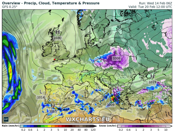
High pressure in charge next week so a lot of overdue drier weather on the way

Outlook: High pressure in charge and at first the position of the high will lead to mild and settled conditions. As the week progresses the high could well slip north and introduce cold, then very cold, easterly winds. Initially the focus will be on it feeling bitter but with a lot of dry and overcast weather.

Follow @ChadWeather on Twitter for your latest weather forecasts.

Thanks,
Jon

Forecast Issued at 13:45 on Wednesday 14th February 2018
Image: http://wxcharts.eu
Thursday 1st February 2018 – Sunday 4th February 2018

Hi all,

January is coming to a close and with just a month left of winter, who’s looking forward to Spring and those lighter mornings and evenings? I know I am, but I’m still hoping for some more snow before we get there.

Thursday: Cold with bright or sunny spells and windy. Just the chance of an isolated wintry shower during the morning mainly in western areas. Max 5°C

Friday: A cold and frosty start then a reasonable day with sunny spells and a chilly wind. Cloudier later in the day. Max 5°C

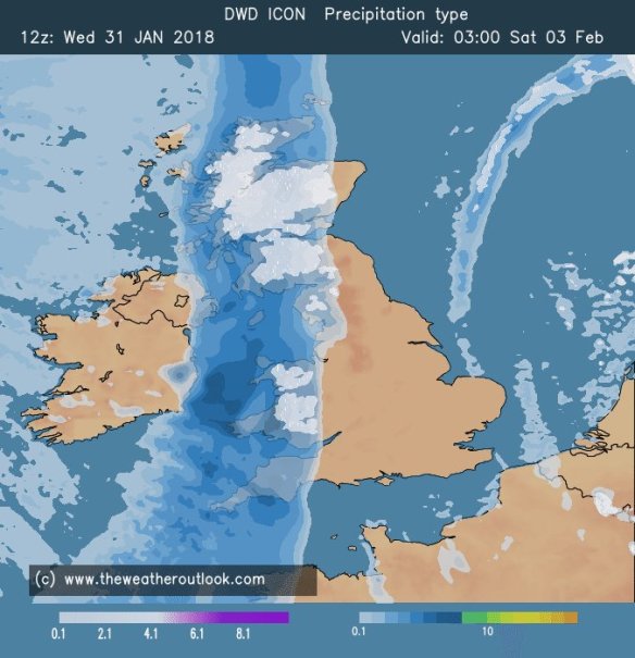
Weekend: Chance of snow

Rain arriving from the west on Saturday could turn to snow

Saturday: A very cold day. Cloudy with rain pushing in from the west. Snow is possible on higher ground (mostly >200M) but not exclusively. So, with a chance of snow to lower-levels, watch out for updates on Twitter. Later into the evening we return to a few wintry showers. Max 3°C

Sunday: A return to the brighter weather with a cold wind and sunny spells. The odd wintry shower possible in eastern areas. Max 5°C

Outlook: Remaining cold throughout with bright spells, slight frosts and some wintry showers. Tuesday/Wednesday could see a band of rain which could turn to snow in places. One to watch.

Follow @ChadWeather on Twitter for the latest forecasts.

Thanks,
Jon

Forecast Issued: Wednesday the 31st of January 2018 at 7:15pm
Image: www.theweatheroutlook.com

Thursday 25th January 2018 – Sunday 28th January 2018

Hi all,

It’s back to the normal British winter. No snow or proper cold in the next 7 days.

Thursday: A few bright spells during the morning but some showers, perhaps heavy and thundery, will arrive into the afternoon and last into the evening. Max 8°C

Friday: A reasonable day. Light winds, some sunny spells and mostly places escaping with a dry day. A touch cooler. Max 7°C

Weekend: Milder with some rain.

Saturday: A dry start but cloud thickening with some outbreaks of rain and drizzle, especially on higher ground, arriving from the southwest. Turning milder. Max 10°C

Mild

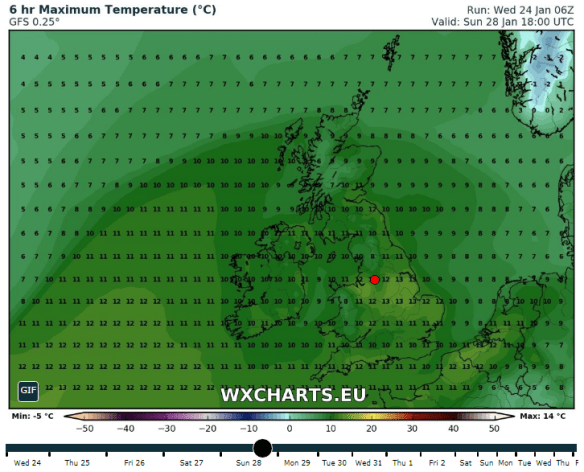
Perhaps a 13°C in some spots on Sunday

Sunday: Cloudy and dull with some patchy light rain and drizzle. Some areas sheltered from the southwesterly wind will remain dry. Much milder with a fresh breeze. Max 12°C

Outlook: A trend towards slightly less mild conditions as we enter February. It looks like we will settle down a touch too, with high pressure close by. No sign of anything particularly cold or snowy but a chance of a few slight frosts.

Follow @ChadWeather on Twitter for the latest forecasts.

Thanks,
Jon

Forecast Issued at 13:15 on Wednesday the 24th of January 2018
Image: http://wxcharts.eu/

Thursday 11th January 2018 – Sunday 14th January 2018

Hi all,

The average maximum temperature for January is about 6°C. Currently we are below, standing at 3.9°C, but with little snow to show for it. I am pinning my hopes on some snow showers next week and a colder end to January but this is just a [hopeful] ‘thought’ and not a certainty.

Thursday: A foggy start, which could cause travel disruption on roads and at the airports, and some patchy frost too. It will be a cold day with some bright spells developing. Fog could linger in places and where it does it will not get much above freezing. Max 4°C

Friday: Little change with a murky start. A dry day to follow with some bright spells
where the low-cloud lifts but general mostly cloudy. Breezy later. Max 5°C

Weekend: Could be better

Saturday: Cloud thickening from the west with some patchy rain arriving slowly. A dull day all round. Max 6°C

Sunday: Any rain easing away and we will see some bright spells developing, but again more cloudy than bright, so a disappointing weekend overall. A more active weather front looks set to sweep rain across the region later on Sunday evening and overnight leading to a more active pattern. Max 5°C

Outlook: After the rain on Sunday we could well see a set-up of cold north-westerly winds with frequent wintry showers, so some snow possible next week, especially so on higher ground and a cold wind for all.

Follow @ChadWeather on Twitter for frequent updates.

December 2017 Stats

Max 11.1°C (7th)
Min -5.2°C (12th)
Av. 4.2°C (below average)
Wettest 13.6mm
Windiest 38mph
Rain 85.4mm (below average)
Rainy Days 28 (grim!)
Dry Days 3
Air Frosts 11
Snow Falling Days 9
Snow Lying Days 4

Thanks,
Jon

Forecast Issued at 1:30pm on Wednesday the 10th of January 2018

Thursday 4th January 2018 – Sunday 7th January 2018

Hi all,

Happy New Year and all the best for 2018!

I hinted that we would end 2017 with a named-storm and in rolled Storm Dylan to be followed by Storm Eleanor yesterday. The Jet Stream has been in charge of our weather in recent days but it will split this weekend and high pressure will build. A northeasterly flow will develop and we will enter a much colder but drier spell of weather.

Thursday: Cloudy with rain for the morning turning showery into the afternoon as the rain band pushes slowly north. We are still in the mild air so temperatures just above average. Max 8°C

Friday: Cloudy with some showers. There will be a little bit of brightness too and as the day progresses, it will get colder. Max 4°C

Weekend: Dry and colder with a biting wind-chill.

Saturday: Cold and mostly dry with some bright spells and the chance of a wintry shower blown in on a freezing northeasterly wind. Widespread frost overnight. Max 4°C

Sunday: Dry with sunny spells after a frosty start. Less breezy, so a pleasant day to get out and about if you’re wrapped up well. Frost returning at night and if winds fall light enough perhaps some fog. Max 4°C

Outlook: High pressure will face a battle with fronts trying to push in from the Atlantic. It will remain cold with plenty of dry weather. Cloud will increase from the west with a risk of rain, preceded by snow, possibly pushing the high pressure away by midweek. If this happens it would turn milder but there’s a reasonable chance that we get ‘locked in’ to the cold for while. Look out for updates on Twitter.

Follow @ChadWeather on Twitter for your weather forecasts.

Thanks,

Jon

Forecast issued at 3:45pm on Wednesday January 3rd 2018

Thursday 14th December 2017 – Sunday 17th December 2017

Hi all,

Sorry it’s a day late. Well what a busy few days that was, and nice to see some snowfall in the early stages of winter. It was a shame (a lot were relieved) that Sunday’s snowfall, which would have been 6 inches or more, ended up further south. Maybe next time…..

Thursday afternoon:  Some bright spells but also some wintry showers. Feeling bitter in the fresh westerly wind. During the evening and overnight a band of rain will move south which could be wintry on higher ground. Max 5°C

Friday: Breezy with Arctic air returning so feeling very cold after a frosty and icy start. Some sunny spells and wintry showers possible, especially to the northeast, so a chance of some hail or snow falling again. Max 4°C

Weekend: Saturday’s the better day.

Saturday:  Still cold with a sunny start but clouding over later in the day. I’m hopeful it does remain dry for most. Max 4°C

Sunday: A change on the way, rain arrives from the southwest and with it much milder air so temperatures lifting. Max 8°C

Outlook: Staying milder than recently with temperatures close to double-figures and with it plenty of cloud which brings a chance of hill-fog and some drizzle or light rain. Look out on Twitter for forecasts for Christmas Day. Early thoughts are, no chance of a White Christmas.

Follow @ChadWeather on Twitter for the latest forecasts.

Thanks,

Jon

Forecast Issued at 12:50pm on Thursday the 14th of December 2017

Thursday 23rd of November 2017 – Sunday 26th November 2017

Hi all,

Well hello weather, we welcomed back our typical Autumn this week, with an inch of rain falling in the first few days. We’ve also had a bit more snow-talk on the grapevine and this time there is some truth in the rumours. No no, don’t get your sledges out just yet, just be ready for a cold weekend with a risk of wintry showers.

Thursday: A mild start with some bright spells but showers will start to appear as the day progresses. Remaining windy and slowly becoming colder. Max 9°C

Friday: A better day and hopefully we will escape with a dry one with sunny spells. It will feel colder again with temperatures really struggling, leading to a slight frost overnight. Max 6°C

Weekend: Cold and breezy with wintry showers and some night-time frosts.

Wintry Showers

Wintry showers, some falling as snow especially on Saturday

Saturday: A bitter day with some bright spells and wintry showers which will could fall as hail or sleet. Some snow showers are possible, in any heavier bursts and certainly more likely on higher ground. Max 5°C

Sunday: More in the way of sunshine with a few wintry showers left over, but there shouldn’t be as many as Saturday. Still cold, especially with the freshening breeze ahead of rain due late-evening and overnight. Max 6°C

Outlook: A touch milder with some rain but then it seems the colder air returns and with it the risk of wintry showers and overnight frosts.

Follow @ChadWeather on Twitter for the latest forecasts.

Thanks,
Jon

Forecast Issued on Wednesday 22nd of November 2017 at 11:35am.
Image: http://wxcharts.eu/

Thursday 16th November 2017 – Sunday 19th November 2017

Hi all,

The chilly feel has continued in November and although we’ve had a few days here and there with milder, damp weather, there’s not been a continous deluge of rain. Currently we’ve only had 29mm (102mm is the monthly average). Is the colder weather a sign of things to come? With La Nina underway there is an increased chance of a colder start to winter. See Liam Dutton’s video for more, La Nina.

Not only is Liam’s video informative, it is also keeping it real.

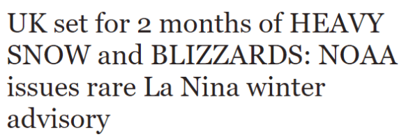
The latest Daily Express headline is more of their clickbait tactics, with over-the-top headlines and untrue statements.

BS

Moving on……

November Stats so far:

Nov 2017

Thursday: A band of patchy rain will move southeastwards during the morning and early afternoon to be replaced by sunny skies and drier conditions but with it, colder air. Max 10°C

Friday: High pressure out west so a settled day with sunny spells and a cold northwesterly breeze. Just the odd shower possible. Max 9°C

Saturday: A breezy day with perhaps a spell of cloud and light rain for a time in the morning. Bright spells developing later with a few showers and still cold. Max 8°C

Sunday: A bright, cold start, perhaps frosty, then cloud increasing with some milder air coming in from the west bringing with it rain as we get into the late-afternoon and evening. Max 8°C

Outlook: Dull and damp on Monday but hopefully drier and brighter thereafter, as high pressure builds. This increases the risk of fog and frost. No snow on the horizon but it will remain cold with temperatures struggling to double-figures.

Follow @ChadWeather on Twitter to keep up to date with the forecasts.

Thanks,
Jon

Forecast Issued: Wednesday 15th November 2017 at 12:30pm

Thursday 9th of November 2017 – Sunday 12th of November 2017

Hi all,

Yep the media are still at it. Anyone got their sledges out? Nope. The weather does have a chill about it, already, but it is anyone’s guess what winter will bring.

Thursday: A cloudy start with milder air back again across the region. Some rain likely in the morning but patchy in nature. This will ease away and some bright spells will break out and lead to a drier afternoon. Max 11°C

Friday: A cloudy and breezy day with bright spells and some showers especially so in the morning. A band of rain moving through overnight. Max 10°C

Weekend: Cold, especially in the wind.

Saturday: A northwesterly airflow will take hold over the UK this weekend and it will feel cold. We’ll see some brightness on Saturday, but also some showers blown in on that keen breeze. Max 9°C

Sunday: A drier day is expected with sunny spells and a few lingering showers. Remaining cold with a frost likely overnight as skies clear. Max 9°C

Outlook: Slowly becoming less cold and cloudier after a decent Monday. Temperatures close or just below average. No sign of any snowfall or any named-storm on the horizon. We could become stuck under a cloudy-high, which means little sunshine but very settled conditions.

Follow @ChadWeather on Twitter for the latest localised forecasts.

You can also view hourly weather stats tweets at @OldhamWxStats and 1-minute data updates from my personal weather station on Wunderground.

Thanks,
Jon

Forecast Issued at 4:30pm on Wednesday the 8th of November
Image: wxcharts

Thursday 19th October 2017 – Sunday 22nd October 2017

Hi all,

Autumn continues to live up to its name as we experienced some wild weather earlier this week. Ex-Hurricane Ophelia (Bizarre Storm) arrived as forecast but we escaped the worst. Chadderton recorded a 44mph gust but generally across the region it was 50-55mph with 70mph along the coast. What was unusual was it wasn’t hammering down with rain. Once morning-showers moved away, some lightning was recorded near Bury, then the day turned very strange indeed. I had noticed a weird ‘light’ on the way to work and soon the sky was filled with rolling cloud that looked very smoke-like and a glowing red sun. Ex-Ophelia’s southerly winds had pushed smoke particles from the Portuguese/Spanish wildfires and Saharan Sand northwards (Red Sun Phenomenon).

As you know we have named-storms and we are currently on ‘B’ as we had Aileen in September. The reason Ophelia wasn’t Brian was because she was already named and since she kept her strength, she remained named the same, even though an ex-Hurricane, as she arrived on our shores.

Storm Brian could well be here quicker than you think……

Thursday: A lot of cloud around but with some bright spells during the day after a misty start. With light winds it will feel pleasant and mild. However, the breeze will pick up later in the day with a risk of some showery rain developing especially to the south and east. Max 16°C

Friday: Fronts will arrive from the west, so a spell of rain which will be followed by brighter conditions and some showers. Breezy and fresher. Max 13°C

Weekend: Poor. Wet and very windy.

Brian

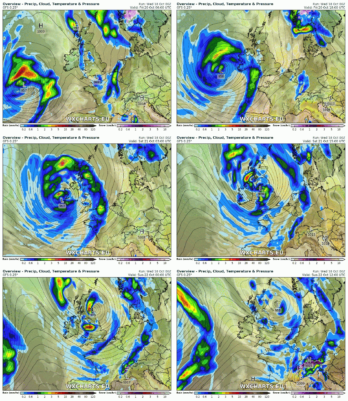
Storm Brian this weekend?


Saturday: A deep area of low pressure will have been forming out west on the Jet Stream and this system could well be named as Storm Brian. At the moment the strongest winds (70mph gusts) look to be heading to Southern Britain, but the track is still uncertain so watch tweets for updates. Currently, it will be a wet day with rain, heavy at times and windy with 40mph gusts. Feeling cold. Max 13°C

Sunday: The ‘storm’ will move into the North Sea but will introduce cold north-easterly winds and with it frequent showers which could be thundery. Remaining windy with gusts possible to 45mph during showers. Max 12°C

Outlook: Remaining unsettled with some spells of wind and rain broken up by some drier slots. Temperatures around or just above average.

Follow @Chadweather on Twitter to keep up to date with the local weather.

Thanks,
Jon

Forecast Issued: Wednesday the 18th of October 2017 at 1pm
Images: WXCHARTS – Follow them on Twitter.