Hi all,
Apologies for the delay today I’ve been exploring the Manchester Christmas Markets and of course the food and beer. So then, a lot of hype this week about colder weather coming and whether it will snow or not and if yes, then how much and where, etc. etc. Interesting times ahead, tricky forecasting times ahead and one thing for sure, cold times ahead. Brrrrr.
Thursday: Storm Caroline brings early heavy, perhaps squally rain, which clears quickly. It will be windy and after a very mild start it will become colder and colder. Sunny spells will arrive with the Arctic air then showers will get going later into the afternoon which will start to turn wintry. Later in the evening and overnight sleet and snow showers will push down from the northwest on a stiff, bitterly cold wind. Don’t be surprised to see a covering of snow on Friday morning. Max 11°C occurring in the morning falling to 6°C by mid-afternoon.

Snow showers pushing down on a bitter NW’ly wind on Thursday night into Friday
Friday: Sleet and snow showers will become confined to western parts and most of us will enjoy some sunshine. It will feel very cold with a significant wind-chill. Max 2°C but feeling more like -3°C. Frost settling in overnight.
Weekend: Plenty of sunshine then a chance of snow.
Saturday: Frosty early and late with sunny spells during the day. Just a chance of a wintry shower to the west where it could be cloudier. Max 4°C

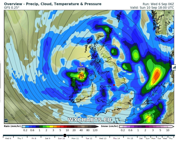
A chance of snow arriving from the southwest on Sunday but details far from certain
Sunday: A forecasters’ nightmare at the moment and be aware things could change. The current model output suggests a dry start but very cold with temperatures close to freezing. Rain coming in from the west or southwest towards midday will engage with the cold air and turn to snow. Some heavy snow looks possible but details at this stage are not certain, i.e. the band of rain/snow could stay away further south, so look out for further updates this week on Twitter. Low-lying areas (under 100M) more prone to sleet but travel disruption could occur in locations above this height. Max 2°C
Outlook: It will remain cold or very cold for the foreseeable with night frosts. There is another chance of snow on Thursday but again details can only be firmed up nearer the time. The cold spell is here to stay.
So to summarise we have a good chance of some snow Thursday into early Friday and also on Sunday.
Follow @ChadWeather on Twitter for up to date forecasts and the latest on the possible snow.
Thanks,
Jon
Forecast issued at 9:50pm on Wednesday the 6th of December 2017
Images: http://wxcharts.eu