Thursday 9th of November 2017 – Sunday 12th of November 2017

Hi all,

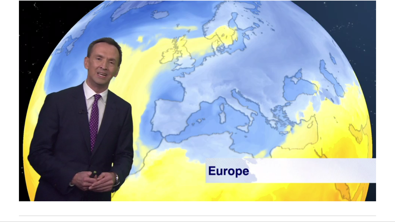
Yep the media are still at it. Anyone got their sledges out? Nope. The weather does have a chill about it, already, but it is anyone’s guess what winter will bring.

Thursday: A cloudy start with milder air back again across the region. Some rain likely in the morning but patchy in nature. This will ease away and some bright spells will break out and lead to a drier afternoon. Max 11°C

Friday: A cloudy and breezy day with bright spells and some showers especially so in the morning. A band of rain moving through overnight. Max 10°C

Weekend: Cold, especially in the wind.

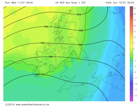
Saturday: A northwesterly airflow will take hold over the UK this weekend and it will feel cold. We’ll see some brightness on Saturday, but also some showers blown in on that keen breeze. Max 9°C

Sunday: A drier day is expected with sunny spells and a few lingering showers. Remaining cold with a frost likely overnight as skies clear. Max 9°C

Outlook: Slowly becoming less cold and cloudier after a decent Monday. Temperatures close or just below average. No sign of any snowfall or any named-storm on the horizon. We could become stuck under a cloudy-high, which means little sunshine but very settled conditions.

Follow @ChadWeather on Twitter for the latest localised forecasts.

You can also view hourly weather stats tweets at @OldhamWxStats and 1-minute data updates from my personal weather station on Wunderground.

Thanks,
Jon

Forecast Issued at 4:30pm on Wednesday the 8th of November
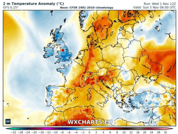
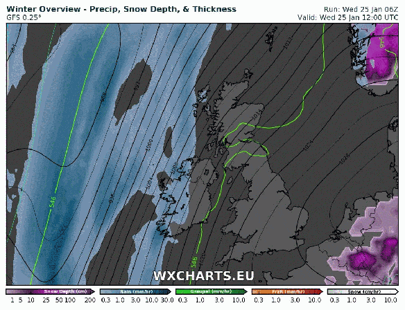
Image: wxcharts

Thursday 2nd November 2017 – Sunday 5th November 2017

Hi all,

Winter is still on the horizon but after a frost this week and a chilly outlook, it will be here sooner, rather than later. A lot of media stories this week; “Coldest Winter in 11 years” etc. etc. Just ignore them. It’s complete guesswork. No-one knows what this winter will bring. Got to love their annual BS.

Thursday: A mostly cloudy start with a risk of some patchy rain moving through but it will soon clear to leave a decent day with plenty of sunny spells and dry. Good news for those off to the Big Bang at Oldham Edge in the evening. Max 12°C

Friday: Cloudy with some light rain or drizzle dotted about especially so into the evening. Some bright spells can’t be ruled out in the odd sheltered location during the morning. Rain overnight. Max 11°C

Colder than average this weekend

Colder than average this weekend

Saturday: Any early morning rain clearing then colder with bright spells and showers which could fall as hail. Feeling cold in a gusty northwesterly wind. Max 9°C

Sunday: Bright spells after a chilly start. Risk of some showers on the keen breeze but these should ease as the day progresses. Remaining cold with temperatures just below average and a frost likely overnight. Max 9°C

Outlook for the rest of next week: High pressure builds from the west, so plenty of dry, settled weather. Not bad during daylight hours with light winds and sunny spells. Some patchy frost and fog overnight. Just one exception is Tuesday where we could have a narrowing band of rain and wind sweep through quickly.

October 2017

Max 19.4°C (16th)
Min 0.9°C (30th)
Av. 11.6°C
Wettest 21.4mm
Windiest 44mph
Rain 105.6mm
Rainy Days 20
Dry Days 11

Follow @ChadWeather on Twitter for the latest forecast for your area.

Cheers
Jon

Images: www.wxcharts.eu
Forecast Issued at 8pm on Wednesday the 1st of November 2017

Thursday 2nd March 2017 – Sunday 5th March 2017

Hi all,

Winter has gone, meteorologically-speaking of course, but we all know we tend to see snow in March at some point, so don’t unpack the garden furniture just yet. Speaking of snow, there could be some overnight on Wednesday with up to 7cm possible above 300M. See Twitter for updates.

Rain likely to turn to snow Wednesday night.


Thursday: Cloudy with rain, sleet and snow during the morning. Drier into the afternoon with some brightness. Breezy too making it feel cold. Some more rain late-evening. Max 7°C

Friday: Some drier, bright spells during the day, but later cloud will thicken with a risk of more rain coming up from the southwest. A cold breeze. Max 7°C

Saturday: A messy picture on Saturday as low pressure from the south swings up another weather front which could stall over the region bringing a wet day with rain at times. There is some uncertainty how far north it gets so watch for updates on my Twitter, @ChadWeather. Max 6°C

Sunday: I’m hoping a little ridge of high pressure builds for Sunday so we have a drier day with some brightness. Temperatures remaining similar values.  Max 7°C

Looking ahead: Temperatures around average, bright spells but also a lot of cloud which will limit the frost-risk. Some showers.

February 2017 Stats

Max 13.1°C (20th)
Min -0.1°C (28th)
Wettest 18.8mm (23rd)
Windiest 49mph (23rd)
Rain 101.8mm (above average)
Rainy Days 23
Dry Days 5
Snow Falling Days 4
Snow Lying Days 1

Thanks,
Jon

Image: http://www.netweather.tv
Forecast Issued: Wednesday 1st of March at 2pm

Thursday 23rd February 2017 – Sunday 26th February 2017

Hi all,

The final blog of winter 16/17 and what a disappointment it has been, when it comes to proper cold and snow. However, even though March is classed as Spring, I expect it will throw some cold spells at us with some snow before we feel the Spring warmth that we’ve all been waiting for.

Before all that, Storm Doris, and with her, an AMBER weather warning which is not that common, even during winter. The storm is yet to form. It will be developing quickly as it approaches and crosses the UK. At the time of publishing these are the warnings: Yellow and Amber Weather Warnings.

warning-areas

The warning areas – we just sit in the AMBER area


Thursday: Be aware that there could be disruptive weather with some structural damage. The day will dawn quite ‘calm’ with what’s to come, with some rain moving in from the west. The rain will become heavy and from mid-morning the winds will increase quickly. Widely we can expect gusts to 50mph. There will be a spell of windier conditions, where we could locally see 60mph gusts and perhaps up to 80mph in exposed places. These gusts are strong enough to damage property and uproot trees. The strongest gusts are expected to be between 11am-3pm but times may vary so watch out for updates on Twitter. As the storm moves through, the winds will turn northwesterly and introduce colder air, so don’t be surprised to see some sleet or snow from mid-afternoon onwards. This is more likely to fall on higher ground (above 300M) and on the Pennines where there will be a few inches. Although it will become less windy into the evening, we can still expect gusts to 40mph. Overnight, further wintry showers with possible hail and feeling colder. Max 9°C which will be during the morning.


snow

Storm Doris will bring a lot of snow to Southern Scotland and Northern England


Friday: A much quieter day. Once you have found your garden furniture, we can expect some showers early on but then drying up and remaining mostly cloudy with less wind. Further rain overnight. Max 6°C

Saturday: Early rain will move through but some blustery showers will follow on behind. Another spell of windy weather with gusts to 35-40mph. Milder. Max 10°C

Sunday: It should be a fine start with some bright spells. Cloud thickening later on as another low pressure comes in with some rain and breezy conditions. Max 9°C

Looking ahead: Next week will start cooler with some showers. The rest of the week will see it slowly turn milder as the weather settles down. Drier conditions favourable but a lot of cloud once more. Let’s hope March sees a decent snowfall before we close the door on Winter 16/17.

Cheers,
Jon

Images: http://wxcharts.eu; http://www.netweather.tv; http://www.metoffice.gov.uk.

Forecast Issued: Wednesday the 22nd of February at 12:00pm


Thursday 16th February 2017 – Sunday 19th February 2017

Hi all,

How awful and baltic was that wind earlier this week? Thankfully the bitter air and howling gale have moved away and we’re back to a slightly milder theme with cloudier skies. The snow predicted last week, did arrive, but again, as seems to be the case these days, it’s saved for the higher ground where conditions were treacherous. 

Thursday: Bright spells here and there. A chance of a shower or two but isolated. Breezy and mild. Showery rain arrives into the evening and overnight. Max 10°C 

Friday: Early showers then slowly drying up, but staying mostly cloudy. Another double-digit day. Max 10°C

Saturday & Sunday: Generally cloudy. Some mist & fog likely in the morning and slow to clear in a few spots. During the day, some drizzle on the hills but other places dry. Any bright spells in sheltered spots away from the mild west to southwesterly flow. Max 9-11°C

Looking ahead: Remaining mild with temperatures around double-figures, possibly higher early in the week. Signs temperatures will drop away later in the month as colder air returns, this time possibly from the northwest.

Follow @ChadWeather on Twitter for your local forecast. 

Cheers
Jon

Forecast Issued: Wednesday the 15th of February at 20:00

Thursday 9th February 2017 – Sunday 12th February 2017

Hi all,

As predicted in the last blog, colder weather with winds from the East is on its way.

As for snow, read on.

Thursday: The colder weather is now upon us with a frosty start. Variable cloud and dry with any bright spells to the west. Feeling very cold with a nagging breeze which might bring some snow flurries. Frosty later and some icy stretches where wintry showers have fallen. Max 3°C

windchill

A subzero windchill over the coming days – several layers needed


Friday: Feeling raw with a bitter, easterly wind and some snow flurries or snow grains in the air. Some bright spells, if any, favoured further west. Frost overnight. Max 2°C but some places in the hills not getting above freezing.

A cold weekend ahead as the easterly flow persists and this could bring snow.

snow-overnight-saturday

Sleet & snow spreading in from the East Saturday evening into Sunday morning


Saturday: Another mostly cloudy day and cold. Later into the evening and overnight a weather system will come in from the North Sea and move westward bringing some snow inland. Some low-lying areas might see rain or sleet. Certainly one to watch. Max 4°C

Sunday: Don’t be surprised to wake up to see a covering of snow especially in areas above 200M. Any rain, sleet or snow should ease away leaving a drier day with bright spells. Becoming less cold later in the day. Max 5°C

milder

Milder from the S or SE early next week, especially on Tuesday


Looking ahead: We lose the freezing, easterly feed so it will become milder and any lying snow will melt quickly. Mostly dry with bright spells and overnight frosts.

I’ve compared this winter so far, to last winter. It just shows how very wet last winter was.

1st Dec-7th Feb

2016

Av. Temp 7.1°C
Rain 371.6mm
Wet Days 62
Dry Days 7

2017

Av. Temp 5.5°C
Rain 145.4mm
Wet Days 49
Dry Days 20

Thanks,
Jon

Forecast Issued: Wednesday the 8th of February 2017 at 12:05
Images: http://www.netweather.tv/ and http://www.ukweatherforecast.co.uk/

Thursday 2nd February 2017 – Sunday 5th February 2017

Hi all,

As we enter February our weather looks to turn wet and windy with a chance of the next named-storm; Storm Doris affecting some parts of the UK.

windy-on-thursday-and-friday

Low pressure in charge Thursday & Friday

Thursday: Low pressure arrives from the southwest so expect it to turn wet and windy with pulses of rain. Some drier slots. Gusts to 40mph likely especially later. Mild throughout. Max 11°C

Friday: A brighter start with some sunshine. Now there is some uncertainty about this but another low pressure could track in from the southwest with the potential for some strong winds with gusts up to 50mph. A warning was issued but now has been cancelled as the low is likely to track futher south. So the thinking is, bright spells and drier during the day, winds increasing later with some rain into the evening. Max 9°C

Cooler over the weekend but any frost limited.

Saturday: Cooler with some showers. Not as windy as recently. Max 6°C

Sunday:  A chilly day with a few scattered showers but in between weather systems means we should have a reasonable day with some bright spells as well. Max 6°C

wintry-showers

Colder with wintry showers midweek next week?

Looking ahead: Rain arriving later on Monday then midweek a chance of wintry showers and colder air from the East to finish the week. Finally some proper cold and snowfall?

cold-air-from-the-east-gif

Proper winter cold from the East arriving later next week?

January 2017 Stats

Max 9.9°C (11th)
Min -2.7°C (5th)
Wettest 12.8mm (15th)
Windiest 41mph (11th)
Rain 82mm
Rainy Days 23
Dry Days 8
Air Frosts Days 7
Snow Falling Days 3
Snow Lying Days 2

Follow @ChadWeather on Twitter to keep up to date with your local weather.

Thanks,
Jon

Forecast Issued on Wednesday the 1st of February 2017 at 12:15
Images: http://wxcharts.eu/

Thursday 26th January 2017 – Sunday 29th January 2017

Hi all,

It is looking like January is going to finish overall, as a calm, cold and dry month. Perhaps February will offer something more ‘lively’ or even snowy? Looking ahead the first week of February does indeed look windier and wetter but no sign of snow. As always, time will tell.

overview

A wetter and windier theme as we enter February?

Thursday: We drag in some of the very cold air that has been stationed across Europe, so it will feel bitter. Mostly cloudy and we can’t rule out the odd snow flurry. Some brightness here and there especially later. A harsh southeasterly wind leading to a significant wind-chill. Plenty of layers needed. It could be the coldest day for up to 2 years. Max 1°C

windchill

A low wind-chill on Thursday making it feel like -5°C

Friday: A cold start but becoming slightly milder later and nowhere near as cold as yesterday. Remaining breezy so it will feel chilly in that wind. Mostly dry and cloudy with limited bright spells. Max 5°C

Saturday: Likely to see some rain in the form of showers at some point, especially into the afternoon . Winds a little lighter. Max 7°C

Sunday: The best day of the weekend. Sunny spells and with light winds it shouldn’t feel too bad. Dry. Max 7°C

wet-and-windy-1

Our next named-storm for early February? #StormDoris

Looking ahead: There is a reasonable chance that the Jet Stream will kick into gear into February so expect wind and rain. As always, keep up to date on Twitter by following @ChadWeather.

Thanks,
Jon

Images: http://wxcharts.eu/
Forecast Issued: Wednesday 25th of January 2017 at 13:15


Thursday 19th January 2017 – Sunday 22nd January 2017

Hi all,

This is one of the most benign forecasts I’ve ever written in my blog. The weather is stuck in a rut and the last few days have been depressing. Drizzle, mizzle, fog, low-cloud and darkness. Horrible. 

To top things off, as you know I’m a cold- and snow-lover, even Spain has been seeing snow today. 

The Polaris World Golf Resort in Condado de Alhama in Spain saw snow on Wednesday


@barrabest on Twitter: Xàbia (Jàvea) Beach on the Costa Blanca, just north of Benidorm, in Spain today. Photo via Patricia Smyth McKeown.

@GVA112 on Twitter – snow falling to sea level this morning on the Valencia Costa


Most of Europe has been cold and snowy and this cold air has extended to most countries bar the U.K. (the SE being an exception for once). 

This graphic from the BBC shows exactly where the cold has spread to across Europe.

So, are we into for a share of this widespread cold. Well we will all become a little colder towards the weekend but we won’t get any snow or anything resembling very cold conditions. 

We have high pressure in charge of our weather but for us it’s a ‘cloudy high’, which means we’ve dragged in a lot of cloud from the west which is ‘trapped’ and can’t escape. With the sun weak at this time of the year, there’s no strength in it to even attempt to burn off the cloud. This leads to a bland outlook. 

Oh, one thing this weather has done, is broken one of my records. The difference between the Max and Min temperatures during a day, is called the diurnal temperature variation. My previous record was 0.9°C in January 2013. This was beaten on Tuesday 17th January 2017 with the range being just 0.8°C thanks to the lack of sun and damp/dull/misty conditions.

See all records here; Chadderton Weather Records.

Thursday: Cloudy and dull, some local drizzle. Misty on the hills. Light winds. Max 8°C

Friday: Another cloudy day. Slightly cooler than yesterday. Again, we can’t rule out drizzle or mizzle. Max 6°C

Saturday and Sunday: An easterly airflow will drag in some slightly colder air so noticeably chilly across the region. There should be enough cloud-cover to limit any frost. Mostly cloudy during the day but a chance of some brightness especially on Sunday. Max 4°C

Looking ahead: Settled early next week before things look to turn unsettled from the west with rain and milder temperatures. Wanting snow and some ‘proper cold’…..then forget it until February

Keep up to date with my local forecasts on Twitter by following @ChadWeather

Thanks,
Jon

Forecast issued: Wednesday 18th January 2017 at 14:20

Images: From Twitter and credited above and BBC Weather

Thursday 12th January 2017 – Sunday 15th January 2017

Hi all,

Headline: Colder with snow for some of us.

Thursday: A very cold northwesterly wind in place which will bring some rain, hail, sleet & snow showers. Some of the snow will settle leading to tricky driving conditions with some ice later but this is expected to be in areas that are above 225M. You can reference the local elevation map or use the link to see what height you are above sea level. Max 3°C but feeling sub-zero in the wind.

wintry-showers-on-thursday

A bitter Thursday with rain, hail, sleet and snow showers in the mix. Snow settled above 200-250M

Use this link to see exactly how many metres you are above sea levelhttp://www.altitude.nu/ or for local locations see the image below.

heights-above-sea-level

Local locations with their height above sea level

Friday: Windy again with a brisk northerly airflow. Some more wintry showers around but they should be less frequent than what we saw on Thursday. Sunny spells in between the showers. Feeling very cold. Sharp frost overnight. Max 3°C

Saturday: Apart from the odd wintry shower, it looks mostly dry with sunny spells and a cold northerly or northwesterly breeze after a frosty start. It will turn frosty again later in the evening but it is likely to cloud over by morning.  Max 3°C

milder-from-the-nw

Milder air comes in from the NW during Sunday recovering temperatures

Sunday: There is still uncertainty about today but it seems that rain will topple in from the northwest which might, initially, fall as sleet or wet-snow on the higher routes. This weather front will also bring milder temperatures.  Max 6°C

Looking ahead: Mild initially but turning slowly colder from midweek with a chance of a cold easterly feed being established.

Keep up to date via my Twitter account, @ChadWeather.

Thanks,
Jon

Images: http://www.chorleyweather.com/, http://ukweatherforecast.co.uk and Oldham Council.

Forecast issued at 16:30 on the 11th of January 2017.