Thursday 29th December 2016 – Sunday 1st January 2017

Hi,

I hope you all had a great Christmas and I wish you all the best for 2017. Here’s hoping for some snow in the early months of next year. At the moment, the start of January is looking like it will offer us some good cold spells and increase the chances of snow. 

Thursday: After a foggy start, more cloud than recent days but remaining dry. Limited sunshine so feeling colder. Max 4°C

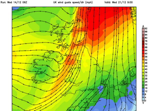
Friday: Mostly cloudy but generally dry. Just a chance of some drizzle developing later, especially on the hills. A fresh southwesterly wind picking up introducing milder air. Max 8°C

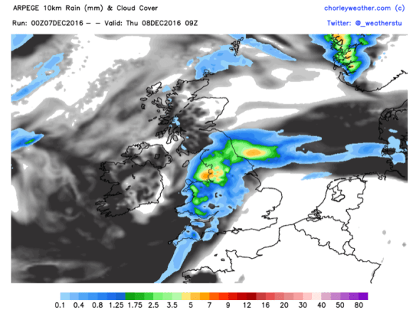
Saturday (New Year’s Eve): A mostly dry cloudy morning, then some patchy rain is possible into the afternoon and evening. Further, more prolonged rain, will arrive overnight followed by much colder air from the Arctic. Max 8°C

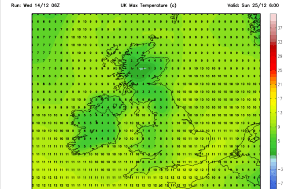
Sunday (New Year’s Day): Sunny spells and wintry showers as colder air reaches all parts from the north. Some showers will fall as hail or sleet with snow showers above 300M. Max 4°C

Outlook: Remaining cold but with a lot of dry weather. Frosts and fog at night. Sunny spells during the day. 

Follow @ChadWeather on Twitter for the latest forecasts. 

Thanks,

Jon

Thursday 22nd December 2016 – Boxing Day 2016

Hi all,

First I would like to wish you all a very Merry Christmas and hope you all enjoy the festivities despite this forecast.

Deep snow? Nah, we have wind and rain to look forward to, and possibly two named storms. After the recent stagnant weather this is a noticeable change especially after a quiet December with rainfall only at 40% of the monthly average.

Thursday: A chilly start with some frost and localised icy patches. Sunny spells and breezy with a risk of a shower or two. These could fall as hail. Feeling cold. Max 7°C

Storm Barbara approaching the U.K.

Friday: A little milder but really not noticeable as Storm Barbara arrives bringing heavy rain after a dry start. It will be windy with gusts of 50mph likely. Weather warning in place. Exposed places could see 60mph. Watch my tweets for updates. Max 10°C

Christmas Eve: Remaining windy with some blustery showers and feeling cold. More rain and wind overnight. Max 8°C

A very mild Christmas Day but colder overnight into Boxing Day

Christmas Day: Early rain, mild and very strong winds. Weather warning in place. There is still some uncertainity about this ‘storm’ and its track. If it develops to be strong enough to be named it will be Storm Conor but at the moment it doesn’t look like it will develop into a system like the one on Friday. During the day we could see gusts to 50mph once again. Later on the rain clears to some scattered blustery showers. Some colder air feeds in overnight, so we could see hail and even some sleet or wet snow to the hills. Max 11°C

The weather calms down as high pressure builds after Boxing Day

Boxing Day and the following few days: Still windy initially then much improved as high pressure builds and the weather eventually ‘relaxes’. Plenty of drier conditions with a risk of some frosts overnight. Chilly at first but maybe becoming slowly milder. Max 7°C

Keep up to date with the latest weather forecast by following @Chadweather on Twitter.

Thanks,
Jon


Forecast issued: 11:00am on Wednesday the 21st of December 2016

Images: http://www.wxcharts.eu; http://www.ukweatherforecast.co.uk; http://www.wetterzentrale.de

Thursday 15th December 2016 – Sunday 18th December 2016

Hi all,

Not long until Christmas and with the big day in range of our long-term forecast models, we can start to get an idea of what the 25th will be like.

Latest suggestion goes for a mild start with temperatures of 8°C, with rain left over from Christmas Eve, clearing during the morning. More updates on Twitter as we approach the festitives.

xmas-day

A mild start to Christmas Day? Certainly no big freeze as per media stories

Thursday: Mostly cloudy and dull. Some rain at times with some drier spells now and again. Plenty of hill-fog and low-cloud. Something we have been used to lately. Max 10°C

Friday: Another cloudy day with low-cloud and some localised drizzle. Mostly dry in the evening as high pressure builds across the UK. Max 10°C

A mostly dry, cooler and settled weekend ahead but sunshine lacking.

Saturday & Sunday: Plenty of dry weather but also a lot of cloud after a cold misty start in places. Some brightness sneaking through, but with plenty of cloud trapped under the high pressure, don’t be banking on it. Cooler. Max 8°C

wind

Dry start to next week perhaps replaced by wind and rain towards midweek

Looking ahead: High pressure in charge for Monday and Tuesday with dry conditions. Wind and rain spreading from the west midweek. Around average temperatures. No sign of any snow.

Follow @ChadWeather on Twitter for your local weather updates.

Thanks,
Jon

Forecast Issued: 15:35 on Wednesday the 14th of December 2016
Images: http://www.netweather.tv

Thursday 8th December 2016 – Sunday 11th December 2016

Hi all,

After a few weeks of relatively cold weather we are back to our more typical December set-up with mild southwesterly winds. I’m still expecting this winter to be colder-than-average but also not expecting any proper cold until we enter the new year. With a southwesterly airflow, rain will not be too far away over the next 48 hours, although the weekend isn’t looking too bad.

Thursday: Rain to start the day, some heavier bursts. It will tend to become drier as we approach lunchtime and the afternoon will remain mild and cloudy with some hill-fog and localised drizzle. Max 13°C

rain-for-thursday

A wet start to Thursday for all

Friday: Another cloudy day with some bright spells. The mild theme continues and some rain is expected as we head into the evening. Breezy. Max 13°C

A cooler but drier weekend ahead.

Saturday: A cloudy start with some rain knocking around from yesterday. The day should then become dry with bright spells but feeling a little fresher. Max 10°C

Sunday: Not a bad day at all. Sunny spells and feeling cool but with lighter winds it shouldn’t feel too bad. Max 8°C


lows-to-nw

Low pressures next week seem to affect the northwest of the UK the most


A mixed bag as we look ahead. Some cooler days and then some milder shots as we get some southwesterly winds again. Some spells of rain, mostly to the northwest of the UK, so more focus on drier and quieter for us. No sign yet of snow or proper cold. I’ll be tweeting some Christmas Day forecasts soon so watch out for those.

Follow @ChadWeather on Twitter for the very latest.

Thanks,
Jon

Forecast issued 13:45 on Wednesday the 7th of December 2016
Image: http://www.chorleyweather.com/


Thursday 1st December 2016 – Sunday 4th December 2016

Hi all,

A late posting this week, washing machine troubles :/. Welcome to the meteorological winter

We have high pressure in charge of our weather and it’s been around for a few days now, which was welcome news after the floods earlier in the month, and it is here to stay.

After some sharp frosts and sunny days earlier this week, things have changed. Earlier in the week the wind was easterly dragging in drier air and clear skies, hence the frost and sunshine. 

The high pressure has now slipped position allowing cloud to topple in from the northwest making for a stale weather pattern.

Thursday to Sunday will all be similar days. Plenty of cloud and mostly dry but just the odd thicker area of cloud might produce drizzle at times.

More cloud-cover means the nights won’t be as frosty and the days will feel cooler with less in the way of sunshine. Hopefully more in the way of sunshine by Sunday.

If breaks do occur overnight we will see some mist or fog as well as a frost.

Max 6-9°C, Min -2°C.

Looking ahead: High pressure continues to be in charge early next week. Variable amounts of cloud. Any breaks allowing sun by day and some frosts by night. Very dry. Possibly a change later in the week as the high is pushed away but not without a fight.

Follow @ChadWeather on Twitter for local weather updates.

Thanks,

Jon

Thursday 24th November 2016 – Sunday 27th November 2016

Hi all,

Well that certainly was an active week of weather. Snow for many places above 250M on Friday morning, followed by 45-50mph gusts and 2-3 inches of rain on Monday, with almost an inch falling in an hour, with serious flash floods following.

Here in Chadderton, some records were broken.

  • 45mm of rain in 1 day beating Boxing Day 2015
  • 21.6mm of rain in any 1-hour period

Again, I would like to thank all those that tweeted me with photos, videos and information about local roads affected. These kind of instant ‘news flashes’ keeps everyone in the know quicker than anything else.

After all that, we have a much quieter week ahead as November eases toward an end.

high-pressure-set-to-hang-around-for-5-6-days

High pressure set to bring drier and settled conditions for the next 5 days


Thursday: 
A chilly start with a local patchy frost. A lovely day ahead with sunny spells and dry. A risk of an overnight frost. Max 8°C

Friday: Similar conditions with maybe more in the way of cloud as bright spells develop during the day. Max 8°C

cloud-cover

A lot of cloud expected this weekend – any breaks likely in western areas


Saturday: 
With an easterly feed now in place, we will drag in more cloud from the North sea. So although it should remain dry, it will feel colder with less sunshine on offer. The cloud however will mean a frost-free night. Max 7°C

Sunday: Little change from yesterday. Cloudy, feeling cold and in places, especially on the hills, the cloud might be thick enough for some drizzle. Max 8°C

Outlook: High pressure to start next week but it is replaced by some rain from the west. Remaining on the chilly side as we go through the week. Early signs point towards a colder start to December.

If you’re into weather charts then have a look at this website, http://wxcharts.eu/, some great charts, features and animations.

To keep up to date with the local weather around Manchester, Tameside and Lancashire then follow @ChadWeather on Twitter.

Thanks,
Jon

Image/GIF: http://wxcharts.eu/

Forecast issued at 16:00 on Wednesday 23rd November 2016


Thursday 17th November 2016 – Sunday 20th November 2016

Hi all,

A bit of a late posting today, but I’m finally here with the usual weekly outlook on what our weather’s going to throw at us. It’s certainly not going to disappoint this week.

Thursday: Cold and windy. Showers of rain and possibly hail and thunder. Some sleet for the hills. There is a chance of more prolonged rain during the morning. 6°C

**There is a possibility that wintry showers will merge together to bring a spell of sleet or snow overnight on Thursday, especially above 200M. One to keep an eye on via my tweets**

Possibilities of some localised sleet and snow overnight Thursday and into Friday morning. Above 200M most at risk.

Friday: Possibly a wintry start as mentioned, then feeling quite bitter with a stiff northwesterly wind and some wintry showers. Sunny spells during the day mixed in with those showers. Showers dying away overnight leading to a frost. 5°C

Heavy rain arrives on Sunday, preceded by Pennine-snow?

Saturday: Frosty start, then a typical pleasant, autumnal day. Sunny spells, just the odd wintry shower but with lighter winds it won’t feel as cold as previous days. 6°C

Sunday: Another cold start with a touch of frost. Cloud soon thickening and the wind increasing as heavy rain, possibly preceded by hill-snow for a time, moves in from the south-west. There is a good deal of uncertainty about how strong the winds could be and how heavy the rain will be so keep your eyes on my tweets. A cold raw feeling day. 7°C

Looking ahead and it’s set to stay cold with unsettled conditions close by. 

Keep up to date with your local weather by following @ChadWeather on Twitter.

Cheers,

Jon

Images: http://www.netweather.tv

Forecast issued Wednesday 16th November at 18:30. 


Thursday 10th November 2016 – Sunday 13th November 2016

Hi all,

So we’re about 10 days into November and some areas have already experienced a ‘winter’ feel with some snow falling on higher ground on Tuesday night and into Wednesday. This is much earlier in the year/season than we are normally accustomed to. As things stand, the ingredients are all there for this coming winter to be a colder-than-average one and possibly, in my opinion, the coldest since 2010/11. Time will tell.

Thursday: An improvement on recent days with bright spells and milder. Some showers expected which could be heavy. Drier into the evening. Max 8°C

Friday: A little cooler again so a fresh feel but better with bright spells and mostly dry conditions. Rain will be trying to push in from the west overnight. Max 7°C

Not a great start to the weekend.

Saturday: Rain heavy at times makes slow progress across the region and slightly milder, showery weather follows. Breezy. Max 10°C

Sunday: Any showers should ease away and an improvement during the day. Bright spells and hopefully most places dry into the afternoon. Max 9°C

A slice of milder air into next week but cooler air should return

Looking ahead and next week looks milder but possibly only for several days then the cooler air returns. Whilst mild, expect some showers or longer spells of rain.

Keep up to date with your local weather forecasts by following @ChadWeather on Twitter.

Thanks,
Jon

Images: http://www.netweather.tv
Forecast Issued: Wednesday 9th November 2016 at 12:20

Thursday 3rd November 2016 – Sunday 6th November 2016

Hi all,

After an exceptionally dry October, which delivered only 18% of our average monthly rainfall, we enter November having certainly changed to much colder weather with our first frost of the season.

Thursday: A cold start but no frost due to cloud-cover. Cloud thickening and a cold wind developing. Some rain arriving towards late-afternoon and evening. If you’re off to Oldham’s Big Bang then pack something warm as well as waterproof. 9°C

Friday: A dull start with some rain, possibly heavy. This will clear to a more showery theme, so some more rain but bright spells in between. 10°C

Once the low pressure that brings Friday’s rain moves on we get another blast of cold Arctic air over the coming weekend. So if you’re off out to see a bonfire and fireworks display over the weekend, wrap up warm. Both Saturday and Sunday evenings look the better option for going out for Bonfire Night.

colder-northerly

Winds from the Arctic again over the weekend – Cold evenings for those bonfires & fireworks


Saturday: Cold with sunny spells. Some showers likely but not everyone catching them. Frosty overnight. Colder. 8°C

Sunday: A frosty start and overnight too. In between sunny spells and there should be plenty of dry weather. 8°C

Looking ahead and next week remains cold, with some overnight frosts and mostly dry conditions. As the week progresses the Atlantic will try and feed in some less cold air and with it some bands of rain. By Thursday it could be mild again.

October 2016 Stats

Max 17.6°C (4th)
Min 4.2°C (22nd)
Wettest 9.4mm (18th)
Windiest 28mph (5th)
Rain 20.4mm (very low)
Rainy Days 19
Dry Days 12

Keep up to date with your local weather forecasts by following @ChadWeather on Twitter.

Thanks,
Jon

Images: http://www.netweather.tv
Forecast Issued: Wednesday 2nd November 2016 at 15:00


Thursday 27th October 2016 – Sunday 30th October 2016

Hi,

October is still on course to be an exceptionally dry month as it comes to an end with little rain to speak of.

With winter on the horizon, the talk (if you can call it that) has already started of “120 days of snow.” etc., etc. There are signs that this winter has a much better chance of being colder-than-average and hence increase the chance of snow, but as always, things can change.

If you would like more detail and not an over-the-top complex view of what our winter set-up could be like, then read my friend’s article, http://www.chorleyweather.com/weak-polar-vortex-could-bring-an-early-uk-winter/.

Currently, we have low pressure to our northwest and high pressure to our south, with us sandwiched in between. We now have a westerly flow so we are milder than recently.

Thursday: Quite cloudy with limited bright spells. Some passing drizzle or light rain possible at times especially on high ground. Breezy but mild. Max 14°C

Friday: Little change. Plenty of cloud and mild. Less of a breeze hopefully. Some localised drizzle but most places staying dry. Max 14°C

Saturday: A dry day with mostly cloudy conditions. Any early mist will lift. Light winds with high pressure close by. Max 13°C

Sunday: Rain could be pushing into western parts of the U.K. but we look to remain dry once again with mostly cloudy skies. Some brightness possible in eastern parts. Max 13°C

Slowly a change to a north or northwesterly airflow next week

Next Week: Not guaranteed but it’s looking more and more likely that winds will turn to come from a colder northerly or northwesterly direction as the week progresses. This will bring sunny spells, the odd shower and daytime temperatures in single-figures as well as possible frosty nights.

Our weather is always changing so keep up to date by following @ChadWeather on Twitter.

Thanks,
Jon

Image: http://www.netweather.tv
Forecast issued at 12:15pm on Wednesday 26th of October 2016