Thursday 23rd March 2017 – Sunday 26th March 2017

Hi all,

Since I last blogged, it feels like it’s never stopped raining. It’s been an awful spell of weather (50mm of rain in the last 6 days) but finally we have some drier and sunnier weather on the way as we enter a settled spell with some warm-feeling Spring sunshine.

Thursday: Rain that moved through on Wednesday will return and be around in the morning but turn patchy during the day with bright or sunny spells developing. A cool northeasterly wind. Max 11°C

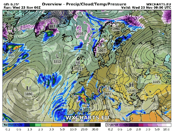
Friday: Low pressure moves away and high pressure topples in and starts to develop across the UK. Sunny spells and dry throughout with the breeze easing. Starting to feel pleasant. A slight frost overnight. Max 11°C

A dry weekend ahead. Yes, dry !

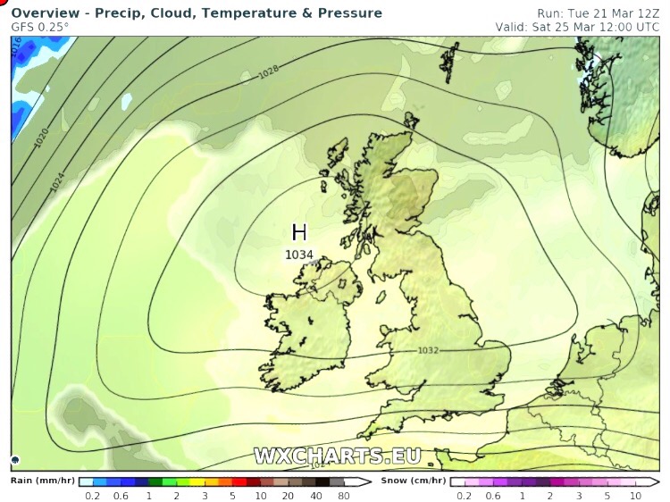
Well Hello High Pressure

Saturday: High pressure firmly in charge. Sunny spells after a cold start with a touch of frost in places. Dry and pleasant in the sunshine with another slight frost overnight. Max 14°C but feeling much warmer in the direct sunshine. [In fact temperatures in the direct sunshine will be around 30°C so it will be nice for sitting out]

Weekend Temps

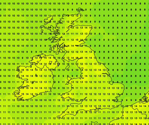
Weekend temperatures looking good – perhaps a little cooler on Sunday

Sunday: The high might slip away slightly. Western areas likely to remain sunnier but cloud could encroach from the east spoiling the sunshine, lets hope it doesn’t. Remaining dry and a slight frost early and later where skies are clear. Max 12°C but cooler where the cloud appears.

Looking ahead: High pressure set to hang around into next week, so more dry conditions and chilly nights. Pleasant by day where the sun shines but still a chance of cloud now and again from the east. Where the sun is out temperatures could get close to the mid-teens.

Follow @ChadWeather on Twitter for the very latest weather updates for in and around Manchester.

Thanks,
Jon

Forecast Issued: Wednesday at 11:30am March 22nd 2017
Images: wxcharts.euhttp://www.netweather.tv

Thursday 9th March 2017 – Sunday 12th March 2017

Hi,

We’ve actually had a couple of reasonable days this week with the recent heavy rain coming overnight last night and tomorrow sees the sunshine continue. 

Thursday: Dry with sunny spells throughout the day. Windy at first but this easing. Feeling pleasant into the afternoon. Max 11°C

Friday: A cloudy day with some hill-fog and rain at times. Most of the rain will be patchy with some drier spells in between. Likely to be drizzly most of the day on the hills. Max 11°C

Saturday: Showery rain likely during the morning but some brighter, drier spells for later in the day. Breezy. Max 10°C

Cooler as the weekend goes on after a mild few days


Sunday: Rain will come in from the west then turn showery and introduce cooler air with some sunny spells. Max 9°C

Looking ahead: Little change at first with similar temperatures and some showery rain. Later in the week perhaps a few days of drying conditions. 

Thanks,
Jon

Forecast Issued: Wednesday the 8th of March 2017 at 8:30pm


Thursday 2nd March 2017 – Sunday 5th March 2017

Hi all,

Winter has gone, meteorologically-speaking of course, but we all know we tend to see snow in March at some point, so don’t unpack the garden furniture just yet. Speaking of snow, there could be some overnight on Wednesday with up to 7cm possible above 300M. See Twitter for updates.

Rain likely to turn to snow Wednesday night.


Thursday: Cloudy with rain, sleet and snow during the morning. Drier into the afternoon with some brightness. Breezy too making it feel cold. Some more rain late-evening. Max 7°C

Friday: Some drier, bright spells during the day, but later cloud will thicken with a risk of more rain coming up from the southwest. A cold breeze. Max 7°C

Saturday: A messy picture on Saturday as low pressure from the south swings up another weather front which could stall over the region bringing a wet day with rain at times. There is some uncertainty how far north it gets so watch for updates on my Twitter, @ChadWeather. Max 6°C

Sunday: I’m hoping a little ridge of high pressure builds for Sunday so we have a drier day with some brightness. Temperatures remaining similar values.  Max 7°C

Looking ahead: Temperatures around average, bright spells but also a lot of cloud which will limit the frost-risk. Some showers.

February 2017 Stats

Max 13.1°C (20th)
Min -0.1°C (28th)
Wettest 18.8mm (23rd)
Windiest 49mph (23rd)
Rain 101.8mm (above average)
Rainy Days 23
Dry Days 5
Snow Falling Days 4
Snow Lying Days 1

Thanks,
Jon

Image: http://www.netweather.tv
Forecast Issued: Wednesday 1st of March at 2pm

Thursday 2nd February 2017 – Sunday 5th February 2017

Hi all,

As we enter February our weather looks to turn wet and windy with a chance of the next named-storm; Storm Doris affecting some parts of the UK.

windy-on-thursday-and-friday

Low pressure in charge Thursday & Friday

Thursday: Low pressure arrives from the southwest so expect it to turn wet and windy with pulses of rain. Some drier slots. Gusts to 40mph likely especially later. Mild throughout. Max 11°C

Friday: A brighter start with some sunshine. Now there is some uncertainty about this but another low pressure could track in from the southwest with the potential for some strong winds with gusts up to 50mph. A warning was issued but now has been cancelled as the low is likely to track futher south. So the thinking is, bright spells and drier during the day, winds increasing later with some rain into the evening. Max 9°C

Cooler over the weekend but any frost limited.

Saturday: Cooler with some showers. Not as windy as recently. Max 6°C

Sunday:  A chilly day with a few scattered showers but in between weather systems means we should have a reasonable day with some bright spells as well. Max 6°C

wintry-showers

Colder with wintry showers midweek next week?

Looking ahead: Rain arriving later on Monday then midweek a chance of wintry showers and colder air from the East to finish the week. Finally some proper cold and snowfall?

cold-air-from-the-east-gif

Proper winter cold from the East arriving later next week?

January 2017 Stats

Max 9.9°C (11th)
Min -2.7°C (5th)
Wettest 12.8mm (15th)
Windiest 41mph (11th)
Rain 82mm
Rainy Days 23
Dry Days 8
Air Frosts Days 7
Snow Falling Days 3
Snow Lying Days 2

Follow @ChadWeather on Twitter to keep up to date with your local weather.

Thanks,
Jon

Forecast Issued on Wednesday the 1st of February 2017 at 12:15
Images: http://wxcharts.eu/

Thursday 5th January 2017 – Sunday 8th January 2017

Hi all,

Happy New Year and all the best for 2017.

The media have been at it again with their annual, or is it now weekly, lies about a Killer Freeze on the way with record low temperatures and more snow than we’ve ever seen before. 

Unfortunately some folk, especially the vulnerable still believe this tripe, so spread the word, never believe their headlines. I’ll be the first to let you know, if we are due any snow and plummeting temperatures. 

Thursday: A very cold and frosty start with temperatures of -4°C in some parts. A lovely, crisp winter’s day follows with plenty of sunshine. Make the most of it as all change ahead. Max 3°C

Fronts coming in from the west bring rain and milder air on Friday

Friday: Cloudy with rain coming in slowly from the west. Some of the rain will be heavy. A cold-feeling day but temperatures on the rise. Max 8°C

Not much sunshine at the weekend but not a washout. 

Saturday: A mild start with some fog and low-cloud over the hills. The latter could persist all day. Hopefully, most of us will get away with a cloudy and dry day but don’t be surprised to see some drizzle, especially on the hills. Max 8°C

Sunday: Little change. Cloudy, again there could be some low-cloud and drizzle towards hillier areas. No frost as temperatures on the milder side. Max 10°C

Wintry showers later next week?

Looking ahead and the following week does see slightly cooler or colder air return with showers, which might be wintry with snow on the hills. Now where’s that Killer Freeze? 🙂

December 2016 Stats

Max 13.3°C (7th)
Min -0.3°C (28th)
Wettest 16.4mm (8th)
Windiest 49mph (23rd)
Rain 46mm (40% of av.)
Rainy Days 19
Dry Days 12

Thanks for all your support on Twitter and with the blog in 2016. Here’s to an eventful weather year in 2017.

Follow @ChadWeather on Twitter for the latest up to date forecasts. 

Thanks
Jon

Issued: Wednesday 4th January 2017 at 14:30

Images: http://www.metoffice.gov.uk; http://www.netweather.tv

Thursday 22nd December 2016 – Boxing Day 2016

Hi all,

First I would like to wish you all a very Merry Christmas and hope you all enjoy the festivities despite this forecast.

Deep snow? Nah, we have wind and rain to look forward to, and possibly two named storms. After the recent stagnant weather this is a noticeable change especially after a quiet December with rainfall only at 40% of the monthly average.

Thursday: A chilly start with some frost and localised icy patches. Sunny spells and breezy with a risk of a shower or two. These could fall as hail. Feeling cold. Max 7°C

Storm Barbara approaching the U.K.

Friday: A little milder but really not noticeable as Storm Barbara arrives bringing heavy rain after a dry start. It will be windy with gusts of 50mph likely. Weather warning in place. Exposed places could see 60mph. Watch my tweets for updates. Max 10°C

Christmas Eve: Remaining windy with some blustery showers and feeling cold. More rain and wind overnight. Max 8°C

A very mild Christmas Day but colder overnight into Boxing Day

Christmas Day: Early rain, mild and very strong winds. Weather warning in place. There is still some uncertainity about this ‘storm’ and its track. If it develops to be strong enough to be named it will be Storm Conor but at the moment it doesn’t look like it will develop into a system like the one on Friday. During the day we could see gusts to 50mph once again. Later on the rain clears to some scattered blustery showers. Some colder air feeds in overnight, so we could see hail and even some sleet or wet snow to the hills. Max 11°C

The weather calms down as high pressure builds after Boxing Day

Boxing Day and the following few days: Still windy initially then much improved as high pressure builds and the weather eventually ‘relaxes’. Plenty of drier conditions with a risk of some frosts overnight. Chilly at first but maybe becoming slowly milder. Max 7°C

Keep up to date with the latest weather forecast by following @Chadweather on Twitter.

Thanks,
Jon


Forecast issued: 11:00am on Wednesday the 21st of December 2016

Images: http://www.wxcharts.eu; http://www.ukweatherforecast.co.uk; http://www.wetterzentrale.de

Thursday 8th December 2016 – Sunday 11th December 2016

Hi all,

After a few weeks of relatively cold weather we are back to our more typical December set-up with mild southwesterly winds. I’m still expecting this winter to be colder-than-average but also not expecting any proper cold until we enter the new year. With a southwesterly airflow, rain will not be too far away over the next 48 hours, although the weekend isn’t looking too bad.

Thursday: Rain to start the day, some heavier bursts. It will tend to become drier as we approach lunchtime and the afternoon will remain mild and cloudy with some hill-fog and localised drizzle. Max 13°C

rain-for-thursday

A wet start to Thursday for all

Friday: Another cloudy day with some bright spells. The mild theme continues and some rain is expected as we head into the evening. Breezy. Max 13°C

A cooler but drier weekend ahead.

Saturday: A cloudy start with some rain knocking around from yesterday. The day should then become dry with bright spells but feeling a little fresher. Max 10°C

Sunday: Not a bad day at all. Sunny spells and feeling cool but with lighter winds it shouldn’t feel too bad. Max 8°C


lows-to-nw

Low pressures next week seem to affect the northwest of the UK the most


A mixed bag as we look ahead. Some cooler days and then some milder shots as we get some southwesterly winds again. Some spells of rain, mostly to the northwest of the UK, so more focus on drier and quieter for us. No sign yet of snow or proper cold. I’ll be tweeting some Christmas Day forecasts soon so watch out for those.

Follow @ChadWeather on Twitter for the very latest.

Thanks,
Jon

Forecast issued 13:45 on Wednesday the 7th of December 2016
Image: http://www.chorleyweather.com/


Thursday 24th November 2016 – Sunday 27th November 2016

Hi all,

Well that certainly was an active week of weather. Snow for many places above 250M on Friday morning, followed by 45-50mph gusts and 2-3 inches of rain on Monday, with almost an inch falling in an hour, with serious flash floods following.

Here in Chadderton, some records were broken.

  • 45mm of rain in 1 day beating Boxing Day 2015
  • 21.6mm of rain in any 1-hour period

Again, I would like to thank all those that tweeted me with photos, videos and information about local roads affected. These kind of instant ‘news flashes’ keeps everyone in the know quicker than anything else.

After all that, we have a much quieter week ahead as November eases toward an end.

high-pressure-set-to-hang-around-for-5-6-days

High pressure set to bring drier and settled conditions for the next 5 days


Thursday: 
A chilly start with a local patchy frost. A lovely day ahead with sunny spells and dry. A risk of an overnight frost. Max 8°C

Friday: Similar conditions with maybe more in the way of cloud as bright spells develop during the day. Max 8°C

cloud-cover

A lot of cloud expected this weekend – any breaks likely in western areas


Saturday: 
With an easterly feed now in place, we will drag in more cloud from the North sea. So although it should remain dry, it will feel colder with less sunshine on offer. The cloud however will mean a frost-free night. Max 7°C

Sunday: Little change from yesterday. Cloudy, feeling cold and in places, especially on the hills, the cloud might be thick enough for some drizzle. Max 8°C

Outlook: High pressure to start next week but it is replaced by some rain from the west. Remaining on the chilly side as we go through the week. Early signs point towards a colder start to December.

If you’re into weather charts then have a look at this website, http://wxcharts.eu/, some great charts, features and animations.

To keep up to date with the local weather around Manchester, Tameside and Lancashire then follow @ChadWeather on Twitter.

Thanks,
Jon

Image/GIF: http://wxcharts.eu/

Forecast issued at 16:00 on Wednesday 23rd November 2016


Thursday 17th November 2016 – Sunday 20th November 2016

Hi all,

A bit of a late posting today, but I’m finally here with the usual weekly outlook on what our weather’s going to throw at us. It’s certainly not going to disappoint this week.

Thursday: Cold and windy. Showers of rain and possibly hail and thunder. Some sleet for the hills. There is a chance of more prolonged rain during the morning. 6°C

**There is a possibility that wintry showers will merge together to bring a spell of sleet or snow overnight on Thursday, especially above 200M. One to keep an eye on via my tweets**

Possibilities of some localised sleet and snow overnight Thursday and into Friday morning. Above 200M most at risk.

Friday: Possibly a wintry start as mentioned, then feeling quite bitter with a stiff northwesterly wind and some wintry showers. Sunny spells during the day mixed in with those showers. Showers dying away overnight leading to a frost. 5°C

Heavy rain arrives on Sunday, preceded by Pennine-snow?

Saturday: Frosty start, then a typical pleasant, autumnal day. Sunny spells, just the odd wintry shower but with lighter winds it won’t feel as cold as previous days. 6°C

Sunday: Another cold start with a touch of frost. Cloud soon thickening and the wind increasing as heavy rain, possibly preceded by hill-snow for a time, moves in from the south-west. There is a good deal of uncertainty about how strong the winds could be and how heavy the rain will be so keep your eyes on my tweets. A cold raw feeling day. 7°C

Looking ahead and it’s set to stay cold with unsettled conditions close by. 

Keep up to date with your local weather by following @ChadWeather on Twitter.

Cheers,

Jon

Images: http://www.netweather.tv

Forecast issued Wednesday 16th November at 18:30. 


Thursday 10th November 2016 – Sunday 13th November 2016

Hi all,

So we’re about 10 days into November and some areas have already experienced a ‘winter’ feel with some snow falling on higher ground on Tuesday night and into Wednesday. This is much earlier in the year/season than we are normally accustomed to. As things stand, the ingredients are all there for this coming winter to be a colder-than-average one and possibly, in my opinion, the coldest since 2010/11. Time will tell.

Thursday: An improvement on recent days with bright spells and milder. Some showers expected which could be heavy. Drier into the evening. Max 8°C

Friday: A little cooler again so a fresh feel but better with bright spells and mostly dry conditions. Rain will be trying to push in from the west overnight. Max 7°C

Not a great start to the weekend.

Saturday: Rain heavy at times makes slow progress across the region and slightly milder, showery weather follows. Breezy. Max 10°C

Sunday: Any showers should ease away and an improvement during the day. Bright spells and hopefully most places dry into the afternoon. Max 9°C

A slice of milder air into next week but cooler air should return

Looking ahead and next week looks milder but possibly only for several days then the cooler air returns. Whilst mild, expect some showers or longer spells of rain.

Keep up to date with your local weather forecasts by following @ChadWeather on Twitter.

Thanks,
Jon

Images: http://www.netweather.tv
Forecast Issued: Wednesday 9th November 2016 at 12:20